Dosya:Ceratopsian map.png

Bu önizlemenin boyutu: 800 × 352 piksel. Diğer çözünürlükler: 320 × 141 piksel | 640 × 282 piksel | 1.427 × 628 piksel.
Tam çözünürlük ((1.427 × 628 piksel, dosya boyutu: 72 KB, MIME tipi: image/png))
Bu dosya Wikimedia Commons'ta bulunmaktadır. Dosyanın açıklaması aşağıda gösterilmiştir. Commons, serbest/özgür telifli medya dosyalarının bulundurulduğu depodur. Siz de yardım edebilirsiniz. |
File:Ceratopsian map.png requires updating
Hi Ceratopsian map.png,
Thank you for your contributions to Commons. I noticed File:Ceratopsian map.png is out of date. Does not include localitiy of Ferrisaurus Could you update it? Thanks again. Extrapolaris (Tartışma) 01:17, 11 November 2019 (UTC) Vahe Demirjian
- @Extrapolaris: Done. Thanks for informing me, next time you could leave message on my talk page directly (in traditional Chinese) so I can see it sooner. -- Tiouraren (Tartışma) 10:21, 31 January 2020 (UTC)
Özet
| Açıklama |
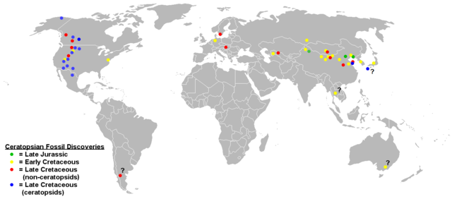
English: Map of ceratopsian fossil localities as of September 2006. I used the blank political map of the world commonly used on Wikipedia ((BlankMap-World.png).
Keep in mind that the land masses would not have been in the same places they are today in the Jurassic and Cretaceous periods. |
| Tarih | 17 Mart 2009 (original upload date) |
| Kaynak | en.wikipedia üzerinden Commons'a FunkMonk tarafından CommonsHelper kullanarak transfer edildi. |
| Yazar | Sheep81 at İngilizce Vikipedi |
Lisanslama
| Bu iş yazarı Sheep81 at İngilizce Vikipedi tarafından kamu malı olarak yayınlanmıştır. Bu dünya çapında geçerlidir. Bazı ülkelerde bu yasal olarak mümkün olmayabilir; öyleyse: Sheep81, bu işi herhangi bir amaç için, herhangi bir şart olmaksızın, yasalarca gerekli olmadıkça, herkesin kullanmasına izin veriyor. |
Orijinal yükleme günlüğü
Dosyanın orjinal açıklama sayfası burada bulunmaktadır. Aşağıdaki tüm kullanıcı adları için en.wikipedia bakın.
- 2009-03-17 18:48 Dinoguy2 1427×628× (47473 bytes) ''Turanoceratops'' as a ceratopsid, not non-ceratopsid (red dot -> blue dot).
- 2006-09-20 06:18 Sheep81 1427×628× (45407 bytes)
- 2006-09-20 04:44 Sheep81 1427×628× (45348 bytes) Map of ceratopsian fossil localities as of September 2006. I used the blank political map of the world commonly used on Wikipedia ((BlankMap-World.png). Keep in mind that the land masses would not have been in the same places they are today in the Jurass
Dosya geçmişi
Dosyanın herhangi bir zamandaki hâli için ilgili tarih/saat kısmına tıklayın.
| Tarih/Saat | Küçük resim | Boyutlar | Kullanıcı | Yorum | |
|---|---|---|---|---|---|
| güncel | 10.11, 31 Ocak 2020 | | 1.427 × 628 (72 KB) | Tiouraren | Added the locality of Ferrisaurus |
| 06.07, 31 Temmuz 2019 |  | 1.427 × 628 (72 KB) | Tiouraren | fixing political border | |
| 14.51, 17 Temmuz 2019 |  | 1.427 × 628 (71 KB) | Tiouraren | Records from Sweden (Lindgren et al., 2007) and Japan (Manabe et al., 2016) added | |
| 07.38, 14 Temmuz 2019 |  | 1.427 × 628 (70 KB) | Tiouraren | Add locality of 50+ basal ceratopsian fossils and Crittendenceratops. | |
| 06.18, 14 Temmuz 2019 |  | 1.427 × 628 (70 KB) | Tiouraren | Turanocertops update | |
| 06.53, 4 Temmuz 2018 |  | 1.427 × 628 (61 KB) | Tiouraren | Add ''Sinoceratops'', ''Koreaceratops'', ''Yehuecauhceratops'', and ''Machairoceratops'' | |
| 21.46, 26 Mart 2009 |  | 1.427 × 628 (46 KB) | File Upload Bot (Magnus Manske) | {{BotMoveToCommons|en.wikipedia|year={{subst:CURRENTYEAR}}|month={{subst:CURRENTMONTHNAME}}|day={{subst:CURRENTDAY}}}} {{Information |Description={{en|Map of ceratopsian fossil localities as of September 2006. I used the blank political map of the world |
Dosya kullanımı
Bu görüntü dosyasına bağlantısı olan sayfalar:
Küresel dosya kullanımı
Aşağıdaki diğer vikiler bu dosyayı kullanır:
- en.wikipedia.org üzerinde kullanımı
- es.wikipedia.org üzerinde kullanımı
- hr.wikipedia.org üzerinde kullanımı
- hu.wikipedia.org üzerinde kullanımı
- ko.wikipedia.org üzerinde kullanımı
- ml.wikipedia.org üzerinde kullanımı
- pl.wikipedia.org üzerinde kullanımı
- sh.wikipedia.org üzerinde kullanımı
- uk.wikipedia.org üzerinde kullanımı
- zh.wikipedia.org üzerinde kullanımı