Dosya:WorldMapCosmasIndicopleustes.jpg
Tam çözünürlük ((1.539 × 1.208 piksel, dosya boyutu: 654 KB, MIME tipi: image/jpeg))
Bu dosya Wikimedia Commons'ta bulunmaktadır. Dosyanın açıklaması aşağıda gösterilmiştir. Commons, serbest/özgür telifli medya dosyalarının bulundurulduğu depodur. Siz de yardım edebilirsiniz. |
Özet
| Açıklama |
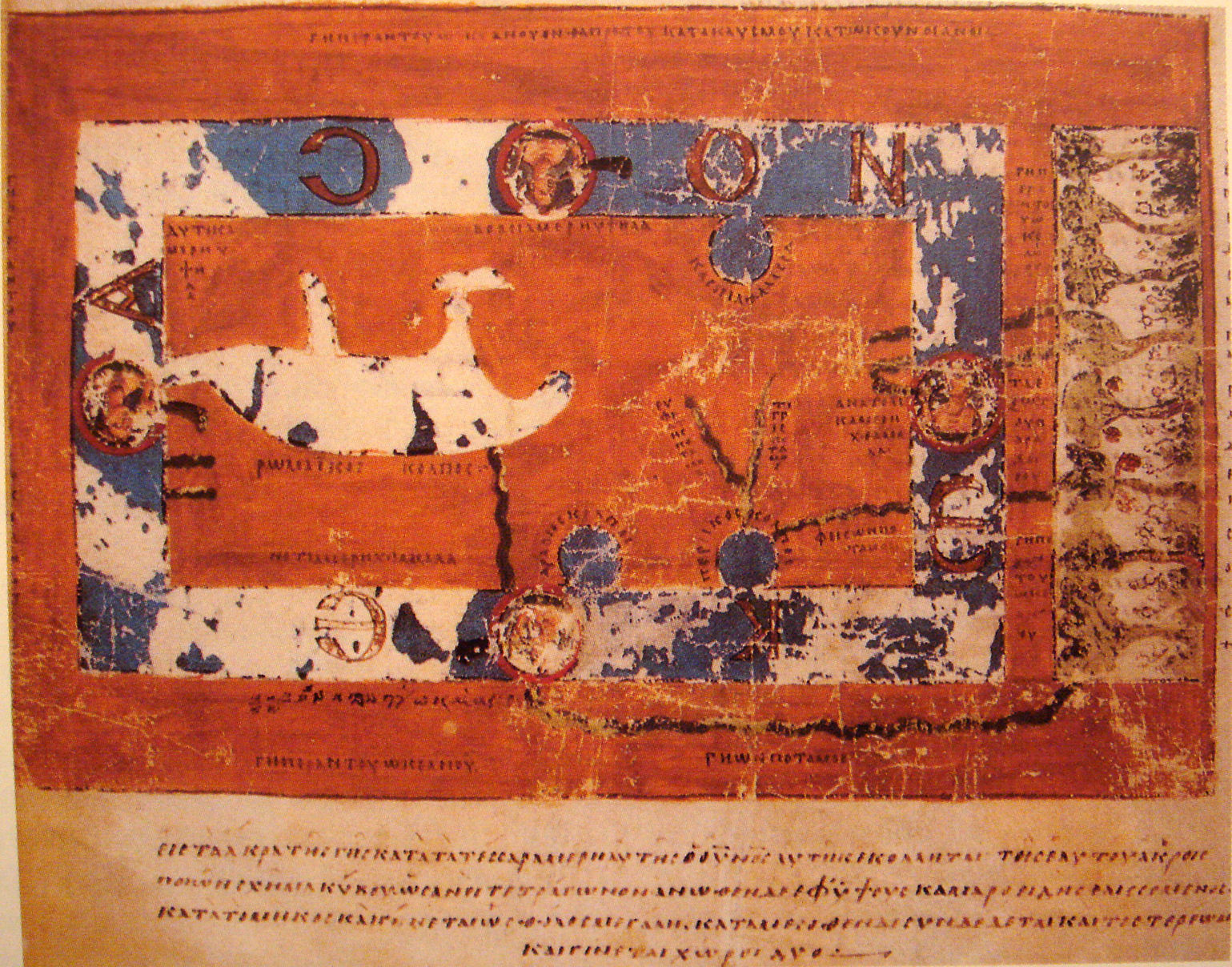
World Map by Cosmas Indicopleustes. The map is oriented with north to the top. It shows a rectangular landmass in the middle of the World Ocean ( ꙌΚΕΑΝΟϹ , Okeanos), reflecting what Cosmas thought was the "floor" of the tabernacle-shaped universe. The Roman Gulf (i.e., Mediterranean) is shown in the western half, with indentations for the unmarked Adriatic and Aegean/Black seas. Three further gulfs are shown: the Caspian to the northeast and the Arabian (i.e., Red Sea) and Persian gulfs to the south. Paradise is shown in the far east, beyond the Ocean. Four rivers run from it and cross under or through the Ocean to reach Asia and Africa. |
| Tarih | 6th century map. |
| Kaynak | "Les Sciences au Moyen-Age", "Pour la Science" |
| Yazar | Cosmas Indicopleustes, 6th century |
| Diğer sürümler |
|

Lisanslama
|
Bu görüntüde gösterilmekte olan iki boyutlu sanat yapıtı,
Dolayısıyla, o sanat yapıtına ait bu tekrar üretim görüntüsü de kamu malıdır.
Tanımlanan durum, ABD (bakınız, Bridgeman Art Library v. Corel Corp. - Bridgeman Sanat Kütüphanesi Corel Şirketine karşı), Almanya ve diğer pek çok ülkede yaratılmış tekrar üretimler için geçerlidir. {{PD-Art}} template without license parameter: please specify why the underlying work is public domain in both the source country and the United States
(Usage: {{PD-Art|1=|deathyear=''year of author's death''|country=''source country''}}, where parameter #1 can be PD-old-auto, PD-old-auto-expired, PD-old-auto-1996, PD-old-100 or similar. See Commons:Multi-license copyright tags for more information.) | ||||
| Annotations | This image is annotated: View the annotations at Commons |
Dosya geçmişi
Dosyanın herhangi bir zamandaki hâli için ilgili tarih/saat kısmına tıklayın.
| Tarih/Saat | Küçük resim | Boyutlar | Kullanıcı | Yorum | |
|---|---|---|---|---|---|
| güncel | 18.33, 16 Kasım 2007 | | 1.539 × 1.208 (654 KB) | World Imaging | {{Information |Description=World Map by Cosmas Indicopleustes |Source="Les Sciences au Moyen-Age", "Pour la Science" |Date=6th century map. |Author=Cosmas Indicopleustes, 6th century |Permission= |other_versions= }} |
Dosya kullanımı
Bu görüntü dosyasına bağlantısı olan sayfalar:
Küresel dosya kullanımı
Aşağıdaki diğer vikiler bu dosyayı kullanır:
- ar.wikipedia.org üzerinde kullanımı
- ca.wikipedia.org üzerinde kullanımı
- ceb.wikipedia.org üzerinde kullanımı
- de.wikipedia.org üzerinde kullanımı
- el.wikipedia.org üzerinde kullanımı
- en.wikipedia.org üzerinde kullanımı
- eo.wikipedia.org üzerinde kullanımı
- es.wikipedia.org üzerinde kullanımı
- fa.wikipedia.org üzerinde kullanımı
- fa.wikibooks.org üzerinde kullanımı
- fi.wikipedia.org üzerinde kullanımı
- fr.wikipedia.org üzerinde kullanımı
- gl.wikipedia.org üzerinde kullanımı
- he.wikipedia.org üzerinde kullanımı
- hr.wikipedia.org üzerinde kullanımı
- id.wikipedia.org üzerinde kullanımı
- it.wikipedia.org üzerinde kullanımı
- it.wikiquote.org üzerinde kullanımı
- ja.wikipedia.org üzerinde kullanımı
- ka.wikipedia.org üzerinde kullanımı
- la.wikipedia.org üzerinde kullanımı
- nl.wikipedia.org üzerinde kullanımı
- pl.wikipedia.org üzerinde kullanımı
Bu dosyanın daha fazla küresel kullanımını görüntüle.