Dosya:Un-morocco.png

Tam çözünürlük ((3.038 × 2.257 piksel, dosya boyutu: 1,31 MB, MIME tipi: image/png))
Bu dosya Wikimedia Commons'ta bulunmaktadır. Dosyanın açıklaması aşağıda gösterilmiştir. Commons, serbest/özgür telifli medya dosyalarının bulundurulduğu depodur. Siz de yardım edebilirsiniz. |
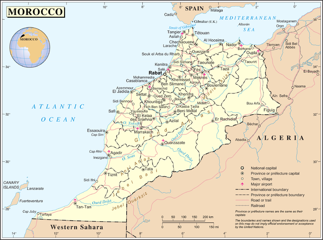
| Açıklama | Map of Morocco | |||
| Tarih | ||||
| Kaynak | The Cartographic Section of the United Nations (CSUN) | |||
| Yazar | Cartographer of the United Nations | |||
| İzin (Bu dosyanın tekrar kullanımı) |
|

Please note that the boundaries of internal administrative division of Morocco in this map (provinces, prefectures, regions etc.) are no longer correct.
Dosya geçmişi
Dosyanın herhangi bir zamandaki hâli için ilgili tarih/saat kısmına tıklayın.
| Tarih/Saat | Küçük resim | Boyutlar | Kullanıcı | Yorum | |
|---|---|---|---|---|---|
| güncel | 15.24, 23 Ekim 2007 | | 3.038 × 2.257 (1,31 MB) | Jeroen | {{UN maps}} Category:Maps of Morocco |
Dosya kullanımı
Bu görüntü dosyasına bağlantısı olan sayfalar:
Küresel dosya kullanımı
Aşağıdaki diğer vikiler bu dosyayı kullanır:
- ar.wikipedia.org üzerinde kullanımı
- bh.wikipedia.org üzerinde kullanımı
- de.wikipedia.org üzerinde kullanımı
- en.wikipedia.org üzerinde kullanımı
- eo.wikipedia.org üzerinde kullanımı
- fr.wikipedia.org üzerinde kullanımı
- id.wikipedia.org üzerinde kullanımı
- lb.wikipedia.org üzerinde kullanımı
- lt.wikipedia.org üzerinde kullanımı
- nl.wikipedia.org üzerinde kullanımı
- pl.wiktionary.org üzerinde kullanımı
- sco.wikipedia.org üzerinde kullanımı
- uk.wikipedia.org üzerinde kullanımı