Dosya:Soviet caucasus1922.png

Bu önizlemenin boyutu: 800 × 571 piksel. Diğer çözünürlükler: 320 × 229 piksel | 640 × 457 piksel | 1.024 × 731 piksel | 1.280 × 914 piksel | 1.613 × 1.152 piksel.
Tam çözünürlük ((1.613 × 1.152 piksel, dosya boyutu: 127 KB, MIME tipi: image/png))
Bu dosya Wikimedia Commons'ta bulunmaktadır. Dosyanın açıklaması aşağıda gösterilmiştir. Commons, serbest/özgür telifli medya dosyalarının bulundurulduğu depodur. Siz de yardım edebilirsiniz. |
Özet
| Açıklama |
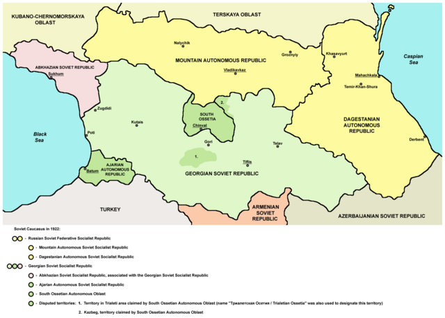
English: Northern part of Soviet Caucasus in 1922 - Mountain Autonomous Soviet Socialist Republic, Dagestanian Autonomous Soviet Socialist Republic, Georgian Soviet Socialist Republic, Abkhazian Soviet Socialist Republic, Ajarian Autonomous Soviet Socialist Republic, South Ossetian Autonomous Oblast and disputed territories claimed by South Ossetian Autonomous Oblast (Trialeti area / Trialetian Ossetia and Kazbeg). |
| Tarih | |
| Kaynak | Yükleyenin kendi çalışması |
| Yazar | PANONIAN |
| Diğer sürümler |
|

Lisanslama
| Ben, bu işin telif sahibi, bu işi kamu malı olarak yayınlıyorum. Bu dünya çapında geçerlidir. Bazı ülkelerde bu yasal olarak mümkün olmayabilir; öyleyse: Ben, bu işi herhangi bir amaç için, herhangi bir şart olmaksızın, yasalarca gerekli olmadıkça, herkesin kullanmasına izin veriyorum. |
References
Made according to these sources:
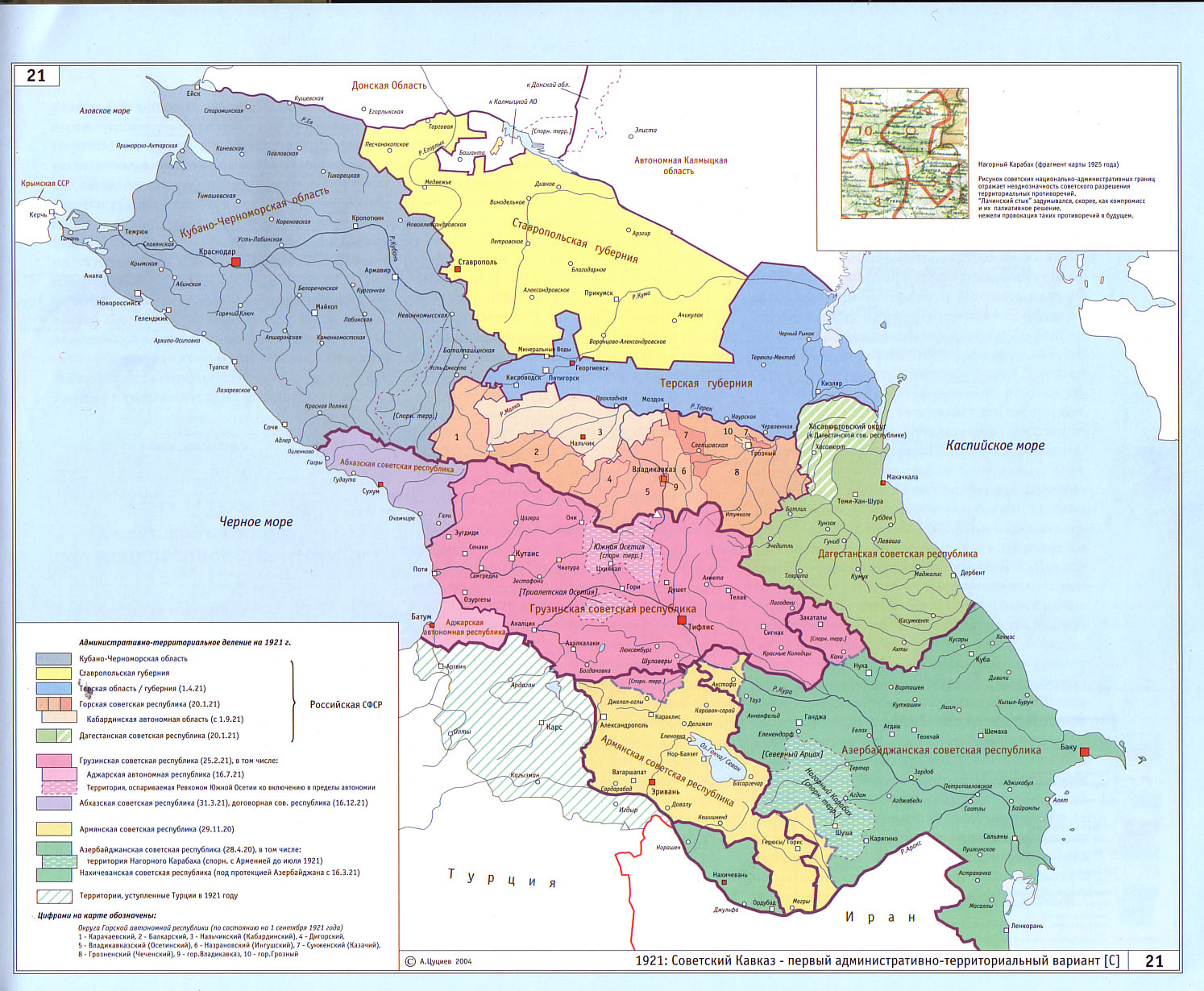
- http://www.iriston.com/books/cuciev_-_etno_atlas/cuciev_etno-polit_map.htm - 50 maps from book "АТЛАС ЭТНОПОЛИТИЧЕСКОЙ ИСТОРИИ КАВКАЗА", Цуциев А.А, Москва: Издательство «Европа», 2007. ("Atlas of ethnopolitical history of Caucasus", Tsutsiev A.A, Moscow: Publisher «Evropa», 2007), inluding a map of Soviet Caucasus in 1921, which show Mountain Autonomous Soviet Socialist Republic, Dagestanian Autonomous Soviet Socialist Republic, Georgian Soviet Socialist Republic, Abkhazian Soviet Socialist Republic, Ajarian Autonomous Soviet Socialist Republic, and disputed territories inhabited by Ossetians: South Ossetia, Trialetian Ossetia and Kazbeg.
- http://dic.academic.ru/pictures/wiki/files/84/Tsutsiev.jpg - map from book "АТЛАС ЭТНОПОЛИТИЧЕСКОЙ ИСТОРИИ КАВКАЗА", Цуциев А.А ("Atlas of ethnopolitical history of Caucasus", Tsutsiev A.A), inluding a map of Soviet Caucasus in 1921, which show Mountain Autonomous Soviet Socialist Republic, Dagestanian Autonomous Soviet Socialist Republic, Georgian Soviet Socialist Republic, Abkhazian Soviet Socialist Republic, Ajarian Autonomous Soviet Socialist Republic, and disputed territories inhabited by Ossetians: South Ossetia, Trialetian Ossetia and Kazbeg.
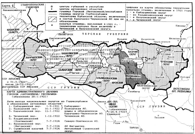
- http://www.iriston.com/nogbon/pictures/Tabol/cuciev_karta_6.jpg - map of Soviet Caucasus in 1922, created by Tsutsiev A.A, which show Mountain Autonomous Soviet Socialist Republic and South Ossetian Autonomous Oblast.
Dosya geçmişi
Dosyanın herhangi bir zamandaki hâli için ilgili tarih/saat kısmına tıklayın.
| Tarih/Saat | Küçük resim | Boyutlar | Kullanıcı | Yorum | |
|---|---|---|---|---|---|
| güncel | 17.03, 26 Aralık 2015 | | 1.613 × 1.152 (127 KB) | PANONIAN | Reverted to version as of 14:47, 27 March 2010 (UTC) - please upload your version under different filename |
| 10.56, 26 Aralık 2015 |  | 1.613 × 1.090 (115 KB) | Ercwlff | corrected georgian city names | |
| 10.45, 26 Aralık 2015 |  | 1.613 × 1.090 (114 KB) | Ercwlff | corrected | |
| 10.42, 26 Aralık 2015 |  | 1.613 × 1.090 (117 KB) | Ercwlff | ~~~~ | |
| 14.47, 27 Mart 2010 |  | 1.613 × 1.152 (127 KB) | PANONIAN | on the second thought, this map is focused on the history of Ossetians and other north Caucasian peoples and therefore disputes areas claimed by Armenia and Azerbaijan are not very relevant subject here | |
| 22.04, 26 Mart 2010 |  | 1.613 × 1.216 (134 KB) | PANONIAN | corrected one description | |
| 22.54, 25 Mart 2010 |  | 1.613 × 1.216 (132 KB) | PANONIAN | new version | |
| 23.52, 23 Mart 2010 |  | 1.613 × 1.122 (121 KB) | PANONIAN | correction | |
| 18.51, 23 Mart 2010 |  | 1.613 × 1.122 (121 KB) | PANONIAN | significant improvement - I hope that this is a final version | |
| 16.32, 23 Mart 2010 |  | 1.227 × 915 (88 KB) | PANONIAN | corrections |
Dosya kullanımı
Bu görüntü dosyasına bağlantısı olan sayfalar:
Küresel dosya kullanımı
Aşağıdaki diğer vikiler bu dosyayı kullanır:
- ar.wikipedia.org üzerinde kullanımı
- ast.wikipedia.org üzerinde kullanımı
- bg.wikipedia.org üzerinde kullanımı
- bn.wikipedia.org üzerinde kullanımı
- br.wikipedia.org üzerinde kullanımı
- ca.wikipedia.org üzerinde kullanımı
- ce.wikipedia.org üzerinde kullanımı
- de.wikipedia.org üzerinde kullanımı
- en.wikipedia.org üzerinde kullanımı
- eo.wikipedia.org üzerinde kullanımı
- es.wikipedia.org üzerinde kullanımı
- et.wikipedia.org üzerinde kullanımı
- fi.wikipedia.org üzerinde kullanımı
- fr.wikipedia.org üzerinde kullanımı
- it.wikipedia.org üzerinde kullanımı
- ja.wikipedia.org üzerinde kullanımı
- kk.wikipedia.org üzerinde kullanımı
- ko.wikipedia.org üzerinde kullanımı
- ku.wikipedia.org üzerinde kullanımı
- lt.wikipedia.org üzerinde kullanımı
- lv.wikipedia.org üzerinde kullanımı
- mk.wikipedia.org üzerinde kullanımı
- no.wikipedia.org üzerinde kullanımı
- os.wikipedia.org üzerinde kullanımı
- pl.wikipedia.org üzerinde kullanımı
Bu dosyanın daha fazla küresel kullanımını görüntüle.