Dosya:PIA10008 Seas and Lakes on Titan.jpg
Tam çözünürlük ((2.348 × 1.900 piksel, dosya boyutu: 2,62 MB, MIME tipi: image/jpeg))
Bu dosya Wikimedia Commons'ta bulunmaktadır. Dosyanın açıklaması aşağıda gösterilmiştir. Commons, serbest/özgür telifli medya dosyalarının bulundurulduğu depodur. Siz de yardım edebilirsiniz. |
Özet
| Açıklama |
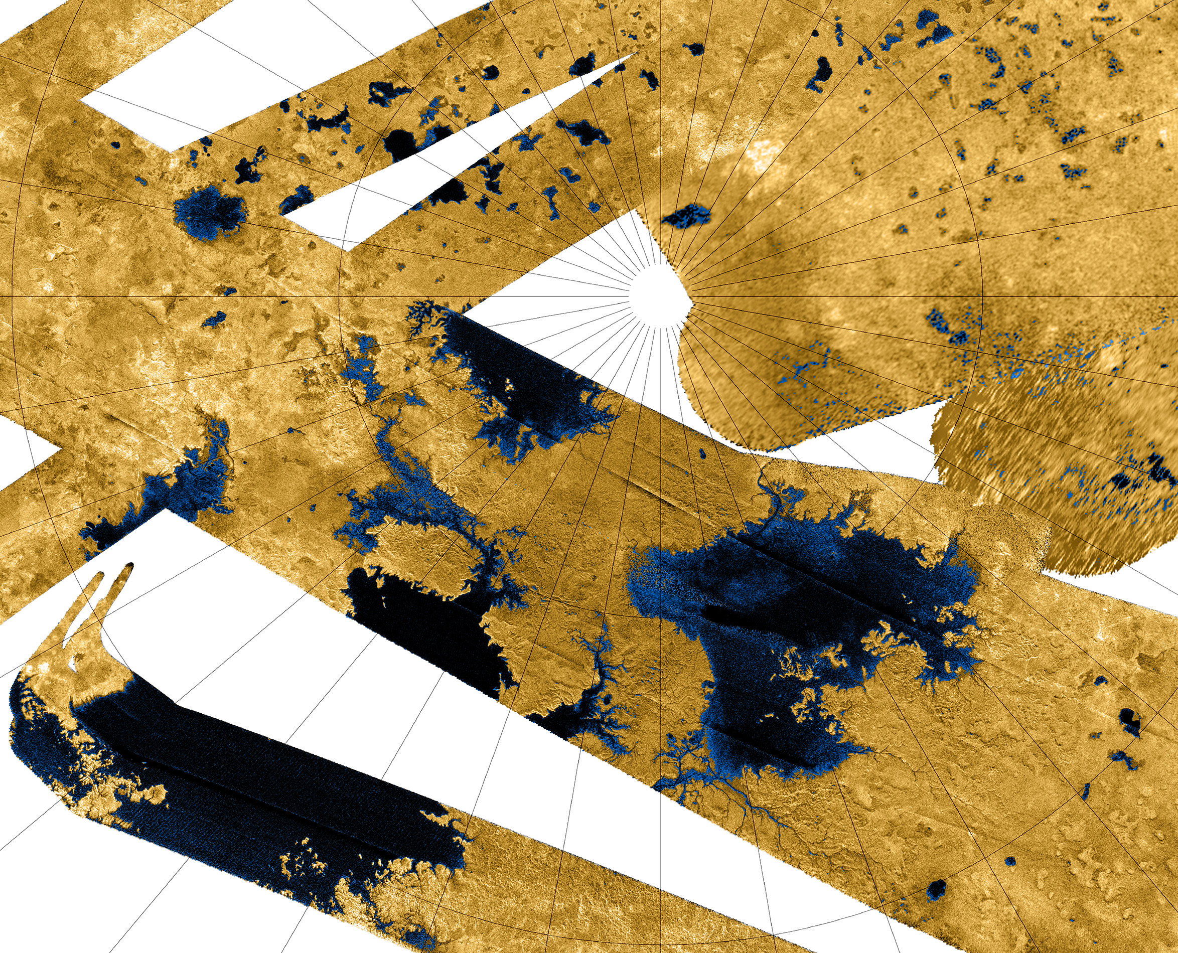
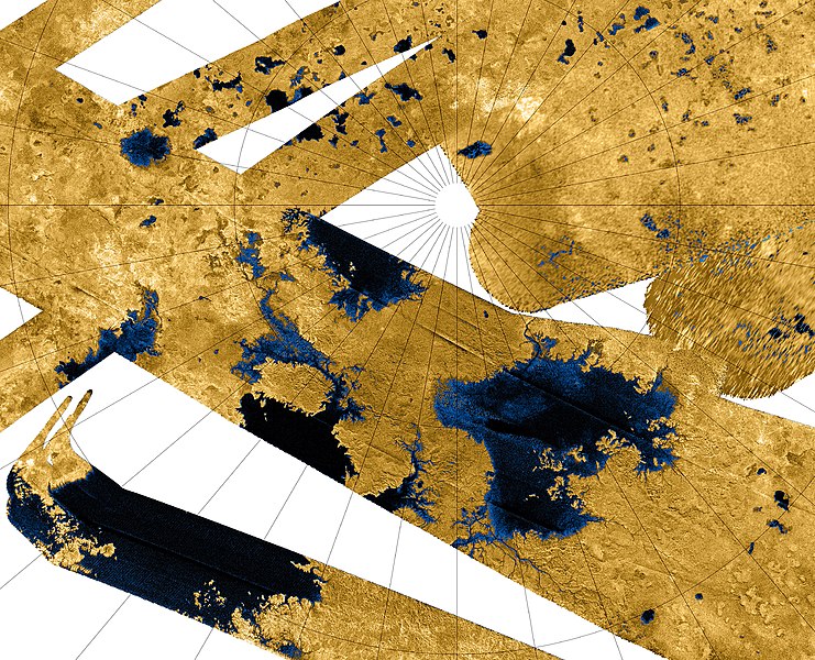
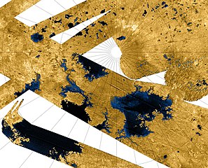
This Cassini false-color mosaic shows all synthetic-aperture radar images to date of Titan's north polar region. Approximately 60 percent of Titan's north polar region, above 60 degrees north latitude, is now mapped with radar. About 14 percent of the mapped region is covered by what is interpreted as liquid hydrocarbon lakes. Features thought to be liquid are shown in blue and black, and the areas likely to be solid surface are tinted brown. The terrain in the upper left of this mosaic is imaged at lower resolution than the remainder of the image Most of the many lakes and seas seen so far are contained in this image, including the largest known body of liquid on Titan. These seas are most likely filled with liquid ethane, methane and dissolved nitrogen. Many bays, islands and presumed tributary networks are associated with the seas. The large feature in the upper right center of this image is at least 100,000 square kilometers (40,000 square miles) in area, greater in extent than Lake Superior (82,000 square kilometers or 32,000 square miles), one of Earth's largest lakes. This Titan feature covers a greater fraction of the surface, at least 0.12 percent, than the Black Sea, Earth's largest terrestrial inland sea, at 0.085 percent. Larger seas may exist, as it is probable that some of these bodies are connected, either in areas unmapped by radar or under the surface (see PIA08365). Of the 400 observed lakes and seas, 70 percent of their area is taken up by large "seas" greater than 26,000 square kilometers (10,000 square miles). The Cassini-Huygens mission is a cooperative project of NASA, the European Space Agency and the Italian Space Agency. The Jet Propulsion Laboratory, a division of the California Institute of Technology in Pasadena, manages the mission for NASA's Science Mission Directorate, Washington, D.C. The Cassini orbiter was designed, developed and assembled at JPL. The radar instrument was built by JPL and the Italian Space Agency, working with team members from the United States and several European countries. For more information about the Cassini-Huygens mission, visit http://saturn.jpl.nasa.gov/home/index.cfm. The original NASA image has been modified by rotating 90 degrees clockwise, cropping and reduction in size (the linear pixel density was reduced 50%). Some of the features in this image have been annotated in Wikimedia Commons. |
| Tarih | |
| Kaynak | http://photojournal.jpl.nasa.gov/catalog/?IDNumber=PIA10008 |
| Yazar | NASA / JPL-Caltech / USGS |
| Diğer sürümler |
PIA10008 Seas and Lakes on Titan full size.jpg - larger, higher resolution version (4696 × 4696 pixels, 10.4 MB) |
Bu görüntü veya video ABD Ulusal Havacılık ve Uzay Dairesi (NASA) Jet Propulsion Labtarafından Fotoğraf ID: PIA10008 ile kataloğa alınmıştır. Bu etiket, ekli çalışmanın telif hakkı durumunu göstermez. Normal bir telif hakkı etiketi hâlâ gereklidir. Commons:Lisanslama sayfasına bakın. Diğer diller:
|
Lisanslama
| Bu dosya NASA tarafından üretildiği için kamu malıdır. Aksi belirtilmediği sürece "NASA tarafından üretilen malzemenin telif hakkı olmadığı" NASA telif politikasında belirtilmiştir. (Bkz. Template:PD-USGov, NASA copyright policy page veya JPL Image Use Policy.) | ||
 |
Uyarılar:
|
| Annotations | This image is annotated: View the annotations at Commons |
Dosya geçmişi
Dosyanın herhangi bir zamandaki hâli için ilgili tarih/saat kısmına tıklayın.
| Tarih/Saat | Küçük resim | Boyutlar | Kullanıcı | Yorum | |
|---|---|---|---|---|---|
| güncel | 03.01, 12 Kasım 2013 | | 2.348 × 1.900 (2,62 MB) | WolfmanSF | Slightly wider view on top and right |
| 09.44, 8 Nisan 2012 |  | 2.280 × 1.840 (2,1 MB) | WolfmanSF | Tweak cropping; add 40 pixels at upper margin to fully display several lakes | |
| 00.18, 16 Aralık 2007 |  | 2.280 × 1.800 (2,05 MB) | WolfmanSF | {{Information |Description=This Cassini false-color mosaic shows all synthetic-aperture radar images to date of Titan's north polar region. Approximately 60 percent of Titan's north polar region, above 60 degrees north latitude, is now mapped with radar. |
Dosya kullanımı
Bu görüntü dosyasına bağlantısı olan sayfalar:
Küresel dosya kullanımı
Aşağıdaki diğer vikiler bu dosyayı kullanır:
- an.wikipedia.org üzerinde kullanımı
- ar.wikipedia.org üzerinde kullanımı
- be.wikipedia.org üzerinde kullanımı
- ca.wikipedia.org üzerinde kullanımı
- cs.wikipedia.org üzerinde kullanımı
- de.wikipedia.org üzerinde kullanımı
- en.wikipedia.org üzerinde kullanımı
- en.wikiversity.org üzerinde kullanımı
- User:Marshallsumter/Radiation astronomy2/Radios
- Solar System, technical/Titan
- Draft:Original research/Titan
- User:Marshallsumter/Radiation astronomy2/Radios/Quiz
- User:Marshallsumter/Radiation astronomy/Courses/Principles/Hourly 3
- User:Marshallsumter/Radiation astronomy2/Radars
- Astronomy college course/Miranda and Titan
- User:Marshallsumter/Radiation astronomy/Courses/Principles/Final quiz
- Titan/Quiz
- Moon/Quiz
- Stars/Sun/Heliology/Quiz
- Earth/Quiz
- Stars/Reds/Quiz
- User:Marshallsumter/Radiation astronomy1/Millimeters/Quiz
- fi.wikipedia.org üzerinde kullanımı
- fr.wikipedia.org üzerinde kullanımı
- gl.wikipedia.org üzerinde kullanımı
- hy.wikipedia.org üzerinde kullanımı
- id.wikipedia.org üzerinde kullanımı
- it.wikipedia.org üzerinde kullanımı
- ja.wikipedia.org üzerinde kullanımı
- mk.wikipedia.org üzerinde kullanımı
- nn.wikipedia.org üzerinde kullanımı
- no.wikipedia.org üzerinde kullanımı
Bu dosyanın daha fazla küresel kullanımını görüntüle.