Dosya:NIT Combined Flights Ground Measurements 30Mar 03Apr2011 results.jpg

Bu önizlemenin boyutu: 800 × 555 piksel. Diğer çözünürlükler: 320 × 222 piksel | 640 × 444 piksel | 1.024 × 710 piksel | 1.245 × 863 piksel.
Tam çözünürlük ((1.245 × 863 piksel, dosya boyutu: 612 KB, MIME tipi: image/jpeg))
Bu dosya Wikimedia Commons'ta bulunmaktadır. Dosyanın açıklaması aşağıda gösterilmiştir. Commons, serbest/özgür telifli medya dosyalarının bulundurulduğu depodur. Siz de yardım edebilirsiniz. |
Özet
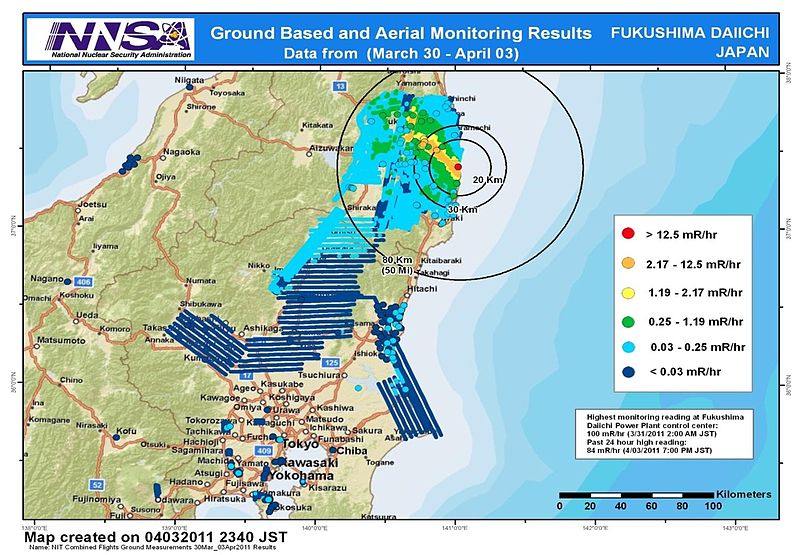
| Açıklama |
English: Combined results of 211 flight hours of aerial monitoring operations and ground measurements made by DOE, DoD and Japanese monitoring teams. |
| Tarih | |
| Kaynak | 4th slide of http://energy.gov/news/documents/AMS_Data_April_4__v1.pptx available at http://blog.energy.gov/content/situation-japan |
| Yazar | National Nuclear Security Administration (NNSA) US Department of Energy |
| Diğer sürümler |
|


Lisanslama
| This image is a work of a United States Department of Energy (or predecessor organization) employee, taken or made as part of that person's official duties. As a work of the U.S. federal government, the image is in the public domain.
Please note that national laboratories operate under varying licences and some are not free. Check the site policies of any national lab before crediting it with this tag.
|

|
Dosya geçmişi
Dosyanın herhangi bir zamandaki hâli için ilgili tarih/saat kısmına tıklayın.
| Tarih/Saat | Küçük resim | Boyutlar | Kullanıcı | Yorum | |
|---|---|---|---|---|---|
| güncel | 09.36, 9 Nisan 2011 | | 1.245 × 863 (612 KB) | Teofilo | cropped |
| 09.26, 9 Nisan 2011 |  | 1.920 × 1.080 (689 KB) | Teofilo | {{Information |Description ={{en|1=Combined results of 211 flight hours of aerial monitoring operations and ground measurements made by DOE, DoD and Japanese monitoring teams.}} |Source =4th slide of http://energy.gov/news/documents/AMS_Data_Ap |
Dosya kullanımı
Bu görüntü dosyasına bağlantısı olan sayfalar:
Küresel dosya kullanımı
Aşağıdaki diğer vikiler bu dosyayı kullanır:
- bg.wikipedia.org üzerinde kullanımı
- de.wikipedia.org üzerinde kullanımı
- en.wikipedia.org üzerinde kullanımı
- en.wikibooks.org üzerinde kullanımı
- es.wikipedia.org üzerinde kullanımı
- it.wikipedia.org üzerinde kullanımı
- ja.wikipedia.org üzerinde kullanımı
- pl.wikipedia.org üzerinde kullanımı
- pt.wikipedia.org üzerinde kullanımı
- so.wikipedia.org üzerinde kullanımı
- sr.wikinews.org üzerinde kullanımı
- th.wikipedia.org üzerinde kullanımı
- www.wikidata.org üzerinde kullanımı
- zh.wikipedia.org üzerinde kullanımı