Dosya:Mingachevir Reservoir, Azerbaijan.JPG

Bu önizlemenin boyutu: 398 × 599 piksel. Diğer çözünürlükler: 159 × 240 piksel | 319 × 480 piksel | 510 × 768 piksel | 680 × 1.024 piksel | 1.361 × 2.048 piksel | 2.829 × 4.256 piksel.
Tam çözünürlük ((2.829 × 4.256 piksel, dosya boyutu: 2,08 MB, MIME tipi: image/jpeg))
Bu dosya Wikimedia Commons'ta bulunmaktadır. Dosyanın açıklaması aşağıda gösterilmiştir. Commons, serbest/özgür telifli medya dosyalarının bulundurulduğu depodur. Siz de yardım edebilirsiniz. |
Özet
| Açıklama |
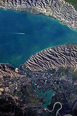
English: This detailed astronaut photograph highlights the southern Mingachevir Reservoir in north-central Azerbaijan. Folded layers of relatively young (less than 5. 3 million years old) sedimentary rock, explosive volcanic products (ash and tuff), and unconsolidated sediments form the grey hills along the northern and southern shorelines of the reservoir (image centre and right). Afternoon sun highlights distinctive parallel patterns in the hills that are the result of water and wind erosion of different rock layers exposed at the surface. The nearby city of Mingachevir (left) is split by the Kur River after it passes through the dam and hydroelectric power station complex at image top centre. The reservoir held approximately 15 billion cubic meters of water at the time this image was taken, with a total engineered capacity of 16 billion cubic meters. The width of the reservoir illustrated here is approximately 8 kilometres; a jet flying over the reservoir left a contrail midway between the shorelines. |
| Tarih | |
| Kaynak | NASA Earth Observatory |
| Yazar | ISS Expedition 23 crew |
| Kamera pozisyonu | | Bu ve diğer görüntülerin konumlarını şurada belirle: OpenStreetMap |
|---|
Bu görüntü veya video ABD Ulusal Havacılık ve Uzay Dairesi (NASA) Johnson Space Centertarafından Fotoğraf ID: ISS023-E-35670 ile kataloğa alınmıştır. Bu etiket, ekli çalışmanın telif hakkı durumunu göstermez. Normal bir telif hakkı etiketi hâlâ gereklidir. Commons:Lisanslama sayfasına bakın. Diğer diller:
|
Image captured with a Nikon D3S digital camera, and is provided by the ISS Crew Earth Observations experiment and Image Science & Analysis Laboratory, Johnson Space Center.
Lisanslama
| Bu dosya NASA tarafından üretildiği için kamu malıdır. Aksi belirtilmediği sürece "NASA tarafından üretilen malzemenin telif hakkı olmadığı" NASA telif politikasında belirtilmiştir. (Bkz. Template:PD-USGov, NASA copyright policy page veya JPL Image Use Policy.) | ||
 |
Uyarılar:
|
| Annotations | This image is annotated: View the annotations at Commons |
Dosya geçmişi
Dosyanın herhangi bir zamandaki hâli için ilgili tarih/saat kısmına tıklayın.
| Tarih/Saat | Küçük resim | Boyutlar | Kullanıcı | Yorum | |
|---|---|---|---|---|---|
| güncel | 10.00, 18 Haziran 2018 | | 2.829 × 4.256 (2,08 MB) | SteinsplitterBot | Bot: Image rotated by 270° |
| 16.54, 7 Haziran 2010 |  | 4.256 × 2.829 (2,09 MB) | Originalwana | {{Information |Description={{en|1=This detailed astronaut photograph highlights the southern Mingachevir Reservoir in north-central Azerbaijan. Folded layers of relatively young (less than 5. 3 million years old) sedimentary rock, explosive volcanic p |
Dosya kullanımı
Bu görüntü dosyasına bağlantısı olan sayfalar:
Küresel dosya kullanımı
Aşağıdaki diğer vikiler bu dosyayı kullanır:
- arz.wikipedia.org üzerinde kullanımı
- azb.wikipedia.org üzerinde kullanımı
- az.wikipedia.org üzerinde kullanımı
- az.wiktionary.org üzerinde kullanımı
- be.wikipedia.org üzerinde kullanımı
- ca.wikipedia.org üzerinde kullanımı
- ceb.wikipedia.org üzerinde kullanımı
- cs.wikipedia.org üzerinde kullanımı
- de.wikipedia.org üzerinde kullanımı
- en.wikipedia.org üzerinde kullanımı
- eo.wikipedia.org üzerinde kullanımı
- es.wikipedia.org üzerinde kullanımı
- fa.wikipedia.org üzerinde kullanımı
- fi.wikipedia.org üzerinde kullanımı
- fr.wikipedia.org üzerinde kullanımı
- fy.wikipedia.org üzerinde kullanımı
- he.wikipedia.org üzerinde kullanımı
- hr.wikipedia.org üzerinde kullanımı
- hu.wikipedia.org üzerinde kullanımı
- hy.wikipedia.org üzerinde kullanımı
- id.wikipedia.org üzerinde kullanımı
- ilo.wikipedia.org üzerinde kullanımı
- it.wikipedia.org üzerinde kullanımı
Bu dosyanın daha fazla küresel kullanımını görüntüle.