Dosya:Iraq.A2003060.0750.500m.jpg

Bu önizlemenin boyutu: 461 × 599 piksel. Diğer çözünürlükler: 184 × 240 piksel | 369 × 480 piksel | 591 × 768 piksel | 788 × 1.024 piksel | 2.000 × 2.600 piksel.
Tam çözünürlük ((2.000 × 2.600 piksel, dosya boyutu: 1.012 KB, MIME tipi: image/jpeg))
Bu dosya Wikimedia Commons'ta bulunmaktadır. Dosyanın açıklaması aşağıda gösterilmiştir. Commons, serbest/özgür telifli medya dosyalarının bulundurulduğu depodur. Siz de yardım edebilirsiniz. |
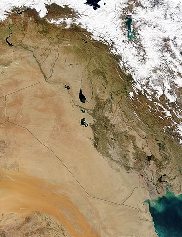
This Moderate Resolution Imaging Spectroradiometer (MODIS) image from March 1, 2003, shows numerous oil well flares (the burning off of combustible gases associated with oil) in southern Iraq (center). The way the active hot spots, marked in red, line up almost vertically suggests they are along a pipeline. Meanwhile, hot spots in southern Iran (right) are likely agricultural fires.
http://visibleearth.nasa.gov/view_rec.php?id=5166
| Bu dosya NASA tarafından üretildiği için kamu malıdır. Aksi belirtilmediği sürece "NASA tarafından üretilen malzemenin telif hakkı olmadığı" NASA telif politikasında belirtilmiştir. (Bkz. Template:PD-USGov, NASA copyright policy page veya JPL Image Use Policy.) | ||
 |
Uyarılar:
|
Dosya geçmişi
Dosyanın herhangi bir zamandaki hâli için ilgili tarih/saat kısmına tıklayın.
| Tarih/Saat | Küçük resim | Boyutlar | Kullanıcı | Yorum | |
|---|---|---|---|---|---|
| güncel | 15.05, 26 Ekim 2005 | | 2.000 × 2.600 (1.012 KB) | Brian0918 | This Moderate Resolution Imaging Spectroradiometer (MODIS) image from March 1, 2003, shows numerous oil well flares (the burning off of combustible gases associated with oil) in southern Iraq (center). The way the active hot spots, marked in red, line up |
Dosya kullanımı
Bu görüntü dosyasına bağlantısı olan sayfalar:
Küresel dosya kullanımı
Aşağıdaki diğer vikiler bu dosyayı kullanır:
- ar.wikipedia.org üzerinde kullanımı
- ar.wikiquote.org üzerinde kullanımı
- da.wikipedia.org üzerinde kullanımı
- en.wikipedia.org üzerinde kullanımı
- fi.wikipedia.org üzerinde kullanımı
- gl.wikipedia.org üzerinde kullanımı
- hr.wikipedia.org üzerinde kullanımı
- hy.wikipedia.org üzerinde kullanımı
- ka.wikipedia.org üzerinde kullanımı
- km.wikipedia.org üzerinde kullanımı
- ko.wikipedia.org üzerinde kullanımı
- lt.wikipedia.org üzerinde kullanımı
- mn.wikipedia.org üzerinde kullanımı
- nn.wikipedia.org üzerinde kullanımı
- no.wikipedia.org üzerinde kullanımı
- nrm.wikipedia.org üzerinde kullanımı
- pl.wikipedia.org üzerinde kullanımı
- pt.wikipedia.org üzerinde kullanımı
- sh.wikipedia.org üzerinde kullanımı
- sl.wikipedia.org üzerinde kullanımı
- sr.wikipedia.org üzerinde kullanımı
- sv.wikipedia.org üzerinde kullanımı
- te.wikipedia.org üzerinde kullanımı
- uk.wikipedia.org üzerinde kullanımı
- zh.wikipedia.org üzerinde kullanımı