Dosya:Europe map 1919.jpg
Tam çözünürlük((1.920 × 1.440 piksel, dosya boyutu: 1,41 MB, MIME tipi: image/jpeg))


Özet

Açıklama
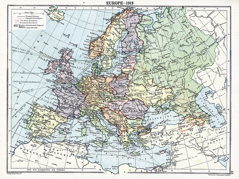
English: Map of en:Europe political divisions in 1919 (after the treaties of Brest-Litovsk and Versailles and before the treaties of Trianon, Riga, Kars and the establishment of en:Soviet Union and the republics of Ireland and Turkey) published by London Geographical Institute. This uploaded map is a photoshopped version of the original image located at hipkiss.org. According to the site, there are no copyrights to this map.
Kaynak
Yazar
Diğer sürümler Bu dosyanın türev çalışmaları:  Europe map 1919 cropped.JPG
Maps of the history of Europe
BCE
aC

Weichselian ice age (c. 113,000–9700) · Neolithic expansion (c. 7000–4500) · Middle Neolithic (c. 4500–4000) · Late Neolithic (c. 4000–3000) · Copper Age – Corded Ware culture (c. 2900–2350) · Copper Age – Bellbeaker culture (c. 2800–1800) · Early Bronze Age – Unetice culture (c. 2300–1600) · Late Bronze Age – Urnfield culture (c. 1300—750) · Migrations (c. 1000–100) · Hallstatt & La Tène cultures (c. 800–100) · Roman Republic (510–40) · 220 · 218 · 200 · 201–100 · 58 · 49 · 39 · 30 BCE–6 CE


CE
dC

14 · 14–37 · 60 · 60 · 69 · 80 · Migrations 100–500 · 117 · 117 · 125 · Migrations 150–774 · Economy 180 · 271 · 293–305 · 337 · 395 · c. 395 · 400 · 400 · 450 · 457–61 · 476 · 480 · Franks 481–814 · Early Slavs 500–700 · 500 · 526 · 526–600 · Christianisation to 600 · c. 550 · 650 · Pontic Steppe 650 · 665 · 800 · Vikings 800–1050 · 814 · 843–70 · 850 · 900 · 912 · 998 · 1000 · 1000 · 1054 · 1092 · First Crusade 1095–99 · 1097 · 1135 · 1142 · 1147–49 · 1190 · 1190 · 1250 · c. 1250 · 1301-1400 · 1301-1400 · 1328 · 1345 · Black Plague 1347–51 · 1360 · 1400 · Trade routes c. 1400 · 1430 · 1470 · 1490 · 1492 · 1500 · 1519 · 1550 · 1560 · Religion 1560 · Religion 1600 · Religion 1618 · 1618–48 · 1648 · 1683 · 1700 · 1701 · 1708 · 1714 · 1721 · 1725–30 · 1739–1740 · 1740 · 1748–66 · 1783–1792 · 1787 · 1787 · 1789 · 1799 · 1812 · 1812 · 1812 · 1812 · 1813 · 1815 · 1815 · 1815 · 1818 · Ottoman Empire 1830–1923 · 1848–49 · 1861 · 1867 · 1871 · 1878 · 1890 · 1905 · 1911 · 1914 · 1914 · 1919 · 1919–29 · 1923 · 1929 · 1930 · 1940 · 1941–42 · 1942–45 · Cold War 1947–91 · 1950 · 1993–2006 · 2006 to date

(this template: · view · discuss )

Lisanslama

Public domain
Public domain
Bu medya dosyası ve içeriği ABD'de kamu malıdır. Bu durum genellikle ABD'de telif hakkı süresi dolmuş eserler için geçerlidir. Çünkü ilk yayınlanması 1 Ocak 1929 tarihinden önce yapılmıştır. Daha fazla açıklama için bu sayfaya bakınız.

United States
United States
Bu görüntü, Amerika Birleşik Devletleri dışında kamu malı olmayabilir; özelikle ABD eserleri için Kanada, Çin Halk Cumhuriyeti (Hong Kong ya da Makao hariç), Almanya, Meksika ve İsviçre' gibi kısa vadeli kuralı geçerli olmayan ülke ve bölgelerde geçerli değildir. Yayını oluşturan ve tarihi gibi temel bilgiler belirtilmelidir. Daha fazla bilgi için Vikipedi:Kamu malı ve Vikipedi:Telif hakları sayfalarına bakabilirsiniz.

Orijinal yükleme günlüğü

Dosyanın orjinal açıklama sayfası burada bulunmaktadır. Aşağıdaki tüm kullanıcı adları için en.wikipedia bakın.
  • 2007-11-03 20:09 MaGioZal 1996×1506×8 (1457003 bytes) Map of [[Europe]] political divisions in 1919 (after the treaties of [[Treaty_of_Brest-Litovsk|Brest-Livotsk]] and [[Treaty of Versailles|Versailles]] and before the [[Treaty of Riga]] and the creation of [[Soviet Union]]) published by London Geographical

Altyazılar

Bu dosyanın temsil ettiği şeyin tek satırlık açıklamasını ekleyin.
The situation in Europe after WW1. Several new states were born such as Ukraine(the country in Yellow at the North of the Black Sea)

Bu dosyada gösterilen öğeler

betimlenen

image/jpeg

Dosya geçmişi

Dosyanın herhangi bir zamandaki hâli için ilgili tarih/saat kısmına tıklayın.

Tarih/SaatKüçük resimBoyutlarKullanıcıYorum
güncel05.41, 7 Ağustos 202305.41, 7 Ağustos 2023 tarihindeki sürümün küçültülmüş hâli1.920 × 1.440 (1,41 MB)User-duckCropped to reduce border using CropTool with lossless mode.
23.29, 22 Nisan 200823.29, 22 Nisan 2008 tarihindeki sürümün küçültülmüş hâli1.996 × 1.506 (1,39 MB)File Upload Bot (Magnus Manske) {{BotMoveToCommons|en.wikipedia}} {{Information |Description={{en|Map of en:Europe political divisions in 1919 (after the treaties of Brest-Livotsk and Versailles and before the treaties o

Bu görüntü dosyasına bağlantısı olan sayfalar:

Küresel dosya kullanımı

Aşağıdaki diğer vikiler bu dosyayı kullanır:

Bu dosyanın daha fazla küresel kullanımını görüntüle.