Dosya:Dall Island and Cordova Bay from space.JPG

Bu önizlemenin boyutu: 800 × 530 piksel. Diğer çözünürlükler: 320 × 212 piksel | 640 × 424 piksel | 1.024 × 678 piksel | 1.280 × 848 piksel | 3.032 × 2.008 piksel.
Tam çözünürlük ((3.032 × 2.008 piksel, dosya boyutu: 1,16 MB, MIME tipi: image/jpeg))
Bu dosya Wikimedia Commons'ta bulunmaktadır. Dosyanın açıklaması aşağıda gösterilmiştir. Commons, serbest/özgür telifli medya dosyalarının bulundurulduğu depodur. Siz de yardım edebilirsiniz. |
Özet
| Açıklama |
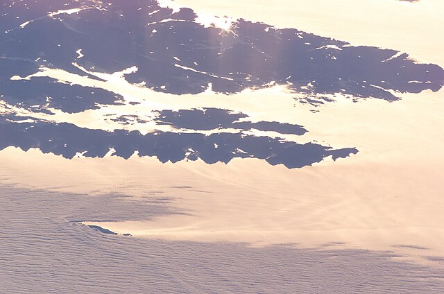
English: Dall island and Cordova Bay photographed from earth orbit, high oblique. NASA data at http://eol.jsc.nasa.gov/scripts/sseop/photo.pl?mission=ISS011&roll=E&frame=9027.
Looking toward the sunrise, a bit north of east. Water appears bright due to sun glint. Dall Island, Long Island, and most of Sukkwan island are visible as dark areas in the middle of the picture, while the land near the top of the picture is Prince of Wales Island. The small island at lower left is Forrester Island. |
| Tarih | |
| Kaynak | Image courtesy of the Image Science & Analysis Laboratory, NASA Johnson Space Center ISS011-E-9027 ftp://eol.jsc.nasa.gov/ESC_large_ISS011_ISS011-E-9027.JPG |
| Yazar | NASA |
Center Point Latitude: 54.9 Center Point Longitude: -132.7
Lisanslama
| Bu dosya NASA tarafından üretildiği için kamu malıdır. Aksi belirtilmediği sürece "NASA tarafından üretilen malzemenin telif hakkı olmadığı" NASA telif politikasında belirtilmiştir. (Bkz. Template:PD-USGov, NASA copyright policy page veya JPL Image Use Policy.) | ||
 |
Uyarılar:
|
Dosya geçmişi
Dosyanın herhangi bir zamandaki hâli için ilgili tarih/saat kısmına tıklayın.
| Tarih/Saat | Küçük resim | Boyutlar | Kullanıcı | Yorum | |
|---|---|---|---|---|---|
| güncel | 03.04, 30 Ağustos 2010 | | 3.032 × 2.008 (1,16 MB) | Dankarl | {{Information |Description={{en|1=Dall island and Cordova Bay photographed from earth orbit, high oblique. NASA data at http://eol.jsc.nasa.gov/scripts/sseop/photo.pl?mission=ISS011&roll=E&frame=9027.}} |Source=Image courtesy of the Image Science & Analys |
Dosya kullanımı
Bu görüntü dosyasına bağlantısı olan sayfalar:
Küresel dosya kullanımı
Aşağıdaki diğer vikiler bu dosyayı kullanır:
- bg.wikipedia.org üzerinde kullanımı
- ca.wikipedia.org üzerinde kullanımı
- en.wikipedia.org üzerinde kullanımı
- id.wikipedia.org üzerinde kullanımı
- it.wikipedia.org üzerinde kullanımı