Dosya:California Congressional Districts, 113th Congress.tif

Bu TIF dosyasının PNG önizlemesinin boyutu: 612 × 599 piksel. Diğer çözünürlükler: 245 × 240 piksel | 490 × 480 piksel | 784 × 768 piksel | 1.045 × 1.024 piksel | 2.441 × 2.391 piksel.
Tam çözünürlük ((2.441 × 2.391 piksel, dosya boyutu: 1,41 MB, MIME tipi: image/tiff))
Bu dosya Wikimedia Commons'ta bulunmaktadır. Dosyanın açıklaması aşağıda gösterilmiştir. Commons, serbest/özgür telifli medya dosyalarının bulundurulduğu depodur. Siz de yardım edebilirsiniz. |
Özet
| Açıklama |
English: Map of Congressional Districts in the state of California, reflecting district boundaries current to the 113th United States Congress. |
| Tarih | |
| Kaynak | National Atlas of the United States (http://nationalatlas.gov/printable/congress.html |
| Yazar | Department of the Interior |
| Diğer sürümler | United States Census Bureau (https://www2.census.gov/geo/maps/cong_dist/uswall/cd116/CD116_US_WallMap.pdf) |
Lisanslama
This image or file is a work of a United States Census Bureau employee, taken or made as part of that person's official duties. As a work of the U.S. federal government, the image is in the public domain.
|
 |
Dosya geçmişi
Dosyanın herhangi bir zamandaki hâli için ilgili tarih/saat kısmına tıklayın.
| Tarih/Saat | Küçük resim | Boyutlar | Kullanıcı | Yorum | |
|---|---|---|---|---|---|
| güncel | 06.00, 2 Şubat 2014 | 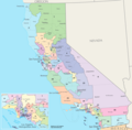 | 2.441 × 2.391 (1,41 MB) | 7partparadigm | User created page with UploadWizard |
Dosya kullanımı
Bu görüntü dosyasına bağlantısı olan sayfalar:
Küresel dosya kullanımı
Aşağıdaki diğer vikiler bu dosyayı kullanır:
- en.wikipedia.org üzerinde kullanımı
- fa.wikipedia.org üzerinde kullanımı
- fr.wikipedia.org üzerinde kullanımı
- ru.wikipedia.org üzerinde kullanımı
- uk.wikipedia.org üzerinde kullanımı
- zh.wikipedia.org üzerinde kullanımı