Dosya:COVID-19 Prevalence in Washington by county.svg

Tam çözünürlük (SVG dosyası, sözde 400 × 263 piksel, dosya boyutu: 39 KB)
Bu dosya Wikimedia Commons'ta bulunmaktadır. Dosyanın açıklaması aşağıda gösterilmiştir. Commons, serbest/özgür telifli medya dosyalarının bulundurulduğu depodur. Siz de yardım edebilirsiniz. |
Özet
| Açıklama |
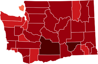
English: {| cellspacing="8" cellpadding="0" style="width:100%; clear:both; margin:0.5em auto; background-color:#f7f8ff; border:2px solid #4488dd; direction:ltr;"
| style="width:50px" | This map shows confirmed cases of w:en:COVID-19, coded by percentage of population confirmed to be infected as of 29 March 2021. The data is used from the data as aggregated and released by Johns Hopkins University and US census (2019 population estimate). As this is a current outbreak, the map might not be up to date. 10.00%+ Confirmed infected
3.00%-10.00% Confirmed infected
1.00%-3.00% Confirmed infected
0.30%-1.00% Confirmed infected
0.10%-0.30% Confirmed infected
0.03%-0.10% Confirmed infected
0.00%-0.03% Confirmed infected
no confirmed cases or no data
The design is based on blank maps available in Public Domain (created by Yiling Chen from TIGER shapefiles), the color scheme is based on color brewer. The script for creating the maps was written by Sukolsak Sakshuwong and Lodewijk Gelauff.
|
||
| Tarih | |||
| Kaynak | Yükleyenin kendi çalışması | ||
| Yazar | Effeietsanders |

Lisanslama
| Bu dosya Creative Commons Evrensel Kamu Malı İthafı altındadır. | |
| Bu çalışmayı oluşturan kişi bu senet ile eser hakkında tüm dünya çapında telif hakkı yasaları kapsamında, yasalar tarafından izin verilen ölçülerde ve diğer benzer tüm haklarından feragat etmiş ve kamu malı olarak nitelendirmiştir. Siz bu çalışmayı ve eseri hiç bir izin almadan ticari amaçlar da dahil olmak üzere kopyalayabilir, değiştirebilir ve serbestçe dağıtabilirsiniz.
|
Dosya geçmişi
Dosyanın herhangi bir zamandaki hâli için ilgili tarih/saat kısmına tıklayın.
| Tarih/Saat | Küçük resim | Boyutlar | Kullanıcı | Yorum | |
|---|---|---|---|---|---|
| güncel | 20.39, 17 Mart 2021 | | 400 × 263 (39 KB) | Eiabot | new data: 16 March 2021 |
| 05.02, 6 Mart 2021 |  | 400 × 263 (39 KB) | Eiabot | new data: 04 March 2021 | |
| 08.04, 13 Şubat 2021 |  | 400 × 263 (39 KB) | Eiabot | new data: 12 February 2021 | |
| 07.26, 9 Şubat 2021 |  | 400 × 263 (39 KB) | Eiabot | new data: 8 February 2021 | |
| 08.50, 7 Şubat 2021 |  | 400 × 263 (39 KB) | Eiabot | new data: 6 February 2021 | |
| 06.18, 6 Şubat 2021 |  | 400 × 263 (39 KB) | Eiabot | new data: 5 February 2021 | |
| 06.30, 23 Ocak 2021 |  | 400 × 263 (39 KB) | Eiabot | new data: 22 January 2021 | |
| 07.24, 22 Ocak 2021 |  | 400 × 263 (39 KB) | Eiabot | new data: 21 January 2021 | |
| 07.27, 21 Ocak 2021 |  | 400 × 263 (39 KB) | Eiabot | new data: 20 January 2021 | |
| 19.17, 14 Ocak 2021 |  | 400 × 263 (39 KB) | Eiabot | new data: 13 January 2020 |
Dosya kullanımı
Bu görüntü dosyasına bağlantısı olan sayfalar:
Küresel dosya kullanımı
Aşağıdaki diğer vikiler bu dosyayı kullanır:
- es.wikipedia.org üzerinde kullanımı
- it.wikipedia.org üzerinde kullanımı