Dosya:Bastogne Map December 19-23 1944.jpg
Bu önizlemenin boyutu: 800 × 477 piksel. Diğer çözünürlükler: 320 × 191 piksel | 640 × 381 piksel | 1.024 × 610 piksel | 1.556 × 927 piksel.
Tam çözünürlük ((1.556 × 927 piksel, dosya boyutu: 1,19 MB, MIME tipi: image/jpeg))
Bu dosya Wikimedia Commons'ta bulunmaktadır. Dosyanın açıklaması aşağıda gösterilmiştir. Commons, serbest/özgür telifli medya dosyalarının bulundurulduğu depodur. Siz de yardım edebilirsiniz. |
Özet
| Açıklama metni | ||||||||||
| Tarih | ||||||||||
| Kaynak | United States Army Center of Military History | |||||||||
| Yaratıcı | ||||||||||
| Geotemporal data | ||||||||||
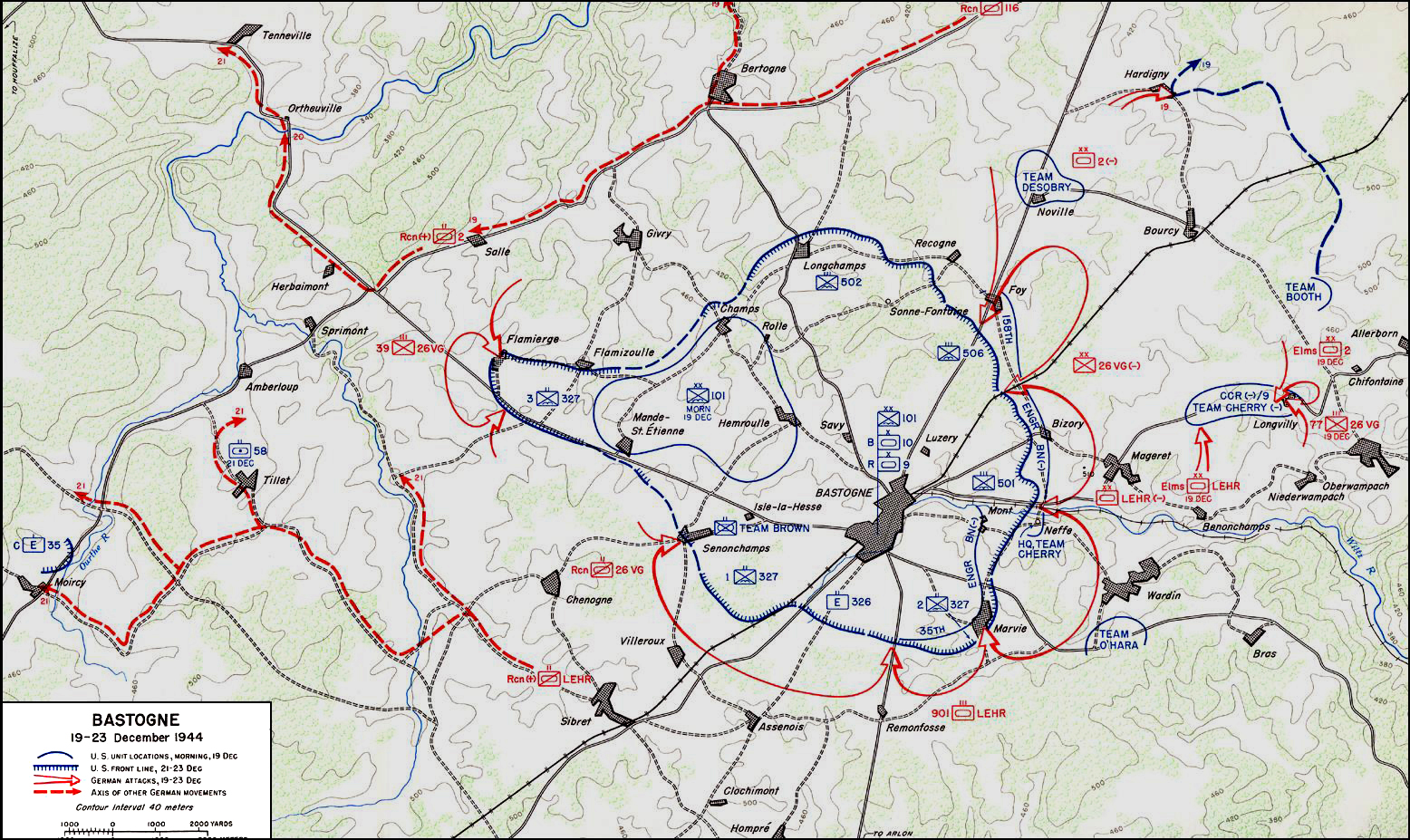
| Tasvir edilen tarih | 19 Aralık 1944 - 23 Aralık 1944 | |||||||||
| Map location | Bastogne | |||||||||
| Heading |
 |
|||||||||
| Bounding box |
|
|||||||||
| Georeferencing | ||||||||||

|
Bu galeride bulunan tüm resimler vektörel grafikler kullanılarak SVG dosyası şeklinde oluşturulmalıdır. Bunun çeşitli avantajları vardır; daha fazla bilgi için Commons:Temizleme medyası sayfasına bakın. Eğer bu resmin SVG formatına sahipseniz, lütfen yükleyin. Lütfen SVG dosyanızı yükledikten sonra, bu şablonu bu resimdeki {{vector version available|yeni resim ismi.svg}} şablonu ile değiştirin.
|


Lisanslama
| This image is in the public domain because it contains materials that originally came from the United States Army Center of Military History, subject to the following qualification.
Note: The images of all badges, insignia, decorations and medals on the "CMH Online" web site are produced by the United States Army Institute of Heraldry and protected by Title 18, United States Code, Section 704 and the Code of Federal Regulations (32 CFR, Part 507). Permission to use these images for commercial purposes must be obtained from The Institute of Heraldry prior to their use. |

|
Dosya geçmişi
Dosyanın herhangi bir zamandaki hâli için ilgili tarih/saat kısmına tıklayın.
| Tarih/Saat | Küçük resim | Boyutlar | Kullanıcı | Yorum | |
|---|---|---|---|---|---|
| güncel | 04.59, 4 Kasım 2006 | | 1.556 × 927 (1,19 MB) | CORNELIUSSEON | {{Information |Description=Bastogne, Belgium Map; december 19-23, 1944. |Source=US Army Center for Military History |Date=December 19-23, 1944 |Author= |Permission={{PD-USGov-Military-Army-USACMH}} – US Army Center for Military History |other_versions= |
Dosya kullanımı
Bu görüntü dosyasına bağlantısı olan sayfalar:
Küresel dosya kullanımı
Aşağıdaki diğer vikiler bu dosyayı kullanır:
- ar.wikipedia.org üzerinde kullanımı
- ca.wikipedia.org üzerinde kullanımı
- de.wikipedia.org üzerinde kullanımı
- el.wikipedia.org üzerinde kullanımı
- en.wikipedia.org üzerinde kullanımı
- en.wikisource.org üzerinde kullanımı
- es.wikipedia.org üzerinde kullanımı
- he.wikipedia.org üzerinde kullanımı
- it.wikipedia.org üzerinde kullanımı
- ja.wikipedia.org üzerinde kullanımı
- nl.wikipedia.org üzerinde kullanımı
- ru.wikipedia.org üzerinde kullanımı
- sl.wikipedia.org üzerinde kullanımı
- ta.wikipedia.org üzerinde kullanımı
- www.wikidata.org üzerinde kullanımı
- zh.wikipedia.org üzerinde kullanımı