Dosya:Banks Penin & Christchurch NZ.jpg
Daha yüksek çözünürlüğe sahip sürüm bulunmamaktadır.
Banks_Penin_&_Christchurch_NZ.jpg ((720 × 480 piksel, dosya boyutu: 452 KB, MIME tipi: image/jpeg))
Bu dosya Wikimedia Commons'ta bulunmaktadır. Dosyanın açıklaması aşağıda gösterilmiştir. Commons, serbest/özgür telifli medya dosyalarının bulundurulduğu depodur. Siz de yardım edebilirsiniz. |
Özet
| Açıklama |
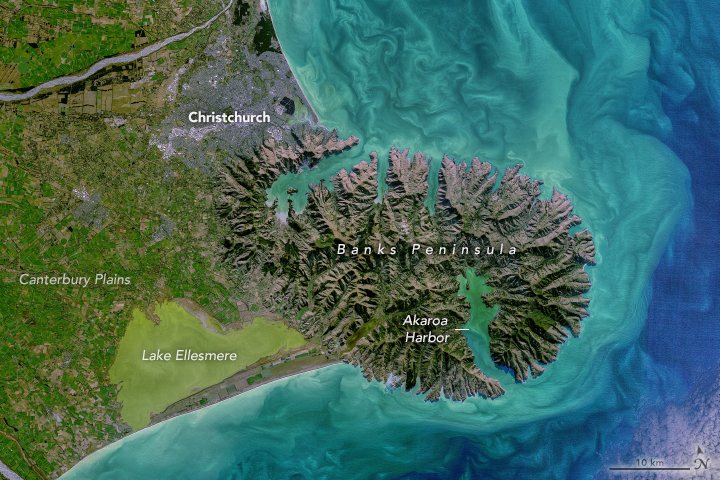
.... the relatively flat, low terrain of Canterbury Plains stands out in green. These now-lush plains were built on rocky material from the Southern Alps that was ground up and deposited during glacial periods and then distributed by rivers flowing toward the Pacific Ocean. Today, the plains are covered in a patchwork of agriculture patterns. The image above shows a detailed view of part of the Canterbury Plains near Christchurch, South Island’s largest city. Two of the area’s braided rivers—the Rakia and Waimakariri—cross the plains as they flow from the Southern Alps toward the ocean. The plains extend eastward until reaching Banks Peninsula (Te Pātaka-o-Rākaihautū), at which point the topography changes drastically. Until about 6 million years ago, Banks Peninsula was an active volcanic complex. Since then, water from the sea and from streams have cut away at the rock, helping to shape the peninsula’s valleys, bays, and coastal cliffs. |
|||||
| Tarih | ||||||
| Kaynak | https://earthobservatory.nasa.gov/images/148852/coastal-color-in-new-zealand?src=eoa-iotd | |||||
| Yazar | NASA Earth Observatory by Norman Kuring/NASA's Ocean Color Web, using Landsat data from the U.S. Geological Survey. Story by Kathryn Hansen | |||||
| İzin (Bu dosyanın tekrar kullanımı) |
|

Dosya geçmişi
Dosyanın herhangi bir zamandaki hâli için ilgili tarih/saat kısmına tıklayın.
| Tarih/Saat | Küçük resim | Boyutlar | Kullanıcı | Yorum | |
|---|---|---|---|---|---|
| güncel | 13.30, 26 Eylül 2021 | | 720 × 480 (452 KB) | Tillman | {{Information |Description= .... the relatively flat, low terrain of Canterbury Plains stands out in green. These now-lush plains were built on rocky material from the Southern Alps that was ground up and deposited during glacial periods and then distributed by rivers flowing toward the Pacific Ocean. Today, the plains are covered in a patchwork of agriculture patterns. The image above shows a detailed view of part of the Canterbury Plains near Christchurch, South Island’s largest city. Two o... |
Dosya kullanımı
Bu görüntü dosyasına bağlantısı olan sayfalar:
Küresel dosya kullanımı
Aşağıdaki diğer vikiler bu dosyayı kullanır:
- en.wikipedia.org üzerinde kullanımı
- uk.wikipedia.org üzerinde kullanımı