Dosya:Australia first map.jpg

Tam çözünürlük ((3.604 × 2.696 piksel, dosya boyutu: 3,81 MB, MIME tipi: image/jpeg))
Bu dosya Wikimedia Commons'ta bulunmaktadır. Dosyanın açıklaması aşağıda gösterilmiştir. Commons, serbest/özgür telifli medya dosyalarının bulundurulduğu depodur. Siz de yardım edebilirsiniz. |
Özet
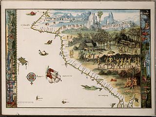
Facsimile of chart from Nicholas Vallard's manuscript sea atlas (1547), showing Jave La Grande's west coast. The facsimile was given the title "The first Map of Australia from Nicholas Vallard's Atlas, 1547" by the English publisher in 1856. The original Vallard chart was produced in Dieppe, France in the 16th century. It is thought by several writers to represent Portuguese charting of the western coast of Australia, however the geographical features (i.e. 'cap' cape, 'Illa' Island, 'illet' islet, 'port' harbour) are actually written in Catalan. This copy is held by the National Library of Australia. [cartographic material] : from the Library of Sir Thomas Phillipps, Bart. at Middle Hill, 1856. Image from the National Library of Australia: http://nla.gov.au/nla.map-rm2393 The original Vallard map is held by the Huntington Library, San Marino, California and can be viewed at http://sunsite3.berkeley.edu/hehweb/HM29.html archive copy at the Wayback Machine
From NLA catalogure information: Scale: Scale indeterminable. Publisher: [Worcestershire : Middle Hill Press, 1856] (Chester : McGahey chromo. lith.) Date: 1856 Material Type: Map Physical Description: 1 map : col. ; 37.6 x 55.4 cm. Notes: Facsimile of chart from Nicholas Vallard's manuscript sea atlas (1547), now held in the Huntington Library, San Marino, California.
Map is in folder with title: Vallard's map of the coast of Greater Java.
Lisanslama
|
Bu çalışma ABD'de veya yazarın yaşamının sona ermiş olmasından 70 veya daha fazla süre geçtiğinde bu duruma uygun telif yasaları olan tüm ülkelerde kamu malıdır.
| |
| Bu dosyanın, tüm ilgili ve komşu haklar da dâhil olmak üzere, telif hakkı yasası kapsamında bilinen kısıtlamalardan arınmış olduğu belirlendi. | |
Dosya geçmişi
Dosyanın herhangi bir zamandaki hâli için ilgili tarih/saat kısmına tıklayın.
| Tarih/Saat | Küçük resim | Boyutlar | Kullanıcı | Yorum | |
|---|---|---|---|---|---|
| güncel | 00.58, 17 Ekim 2006 | | 3.604 × 2.696 (3,81 MB) | Gobeirne | |
| 22.55, 30 Kasım 2005 |  | 760 × 580 (110 KB) | Matilda | First map of Australia [cartographic material] : from Nicholas Vallard's atlas, 1547, in the Library of Sir Thomas Phillipps, Bart. at Middle Hill, 1856. Image from the National Library of Australia: http://nla.gov.au/nla.map-rm2393 From NLA catalogure i |
Dosya kullanımı
Bu görüntü dosyasına bağlantısı olan sayfalar:
Küresel dosya kullanımı
Aşağıdaki diğer vikiler bu dosyayı kullanır:
- af.wikipedia.org üzerinde kullanımı
- en.wikipedia.org üzerinde kullanımı
- es.wikipedia.org üzerinde kullanımı
- fr.wikipedia.org üzerinde kullanımı
- he.wikipedia.org üzerinde kullanımı
- id.wikipedia.org üzerinde kullanımı
- it.wikipedia.org üzerinde kullanımı
- ja.wikipedia.org üzerinde kullanımı
- jv.wikipedia.org üzerinde kullanımı
- ka.wikipedia.org üzerinde kullanımı
- mk.wikipedia.org üzerinde kullanımı
- nl.wikipedia.org üzerinde kullanımı
- pt.wikipedia.org üzerinde kullanımı
- Descoberta da Austrália
- Predefinição:Esboço-históriaau
- Mapas de Dieppe
- Colônia de Nova Gales do Sul
- Ordem da Austrália
- Teoria da descoberta da Austrália pelos portugueses
- Eureka Stockade
- Federação da Austrália
- Austrália Branca
- Colônia da Tasmânia
- Colônia de Queensland
- Federalismo na Austrália
- João Alfonso
- ru.wikipedia.org üzerinde kullanımı
- ru.wikiversity.org üzerinde kullanımı
- sr.wikipedia.org üzerinde kullanımı
Bu dosyanın daha fazla küresel kullanımını görüntüle.