Dosya:1846 Mitchell's Map of Texas Oregon and California - Geographicus - TXORCA-mitchell-1846.jpg
Bu önizlemenin boyutu: 553 × 599 piksel. Diğer çözünürlükler: 221 × 240 piksel | 443 × 480 piksel | 708 × 768 piksel | 945 × 1.024 piksel | 1.889 × 2.048 piksel | 5.000 × 5.420 piksel.
Tam çözünürlük ((5.000 × 5.420 piksel, dosya boyutu: 5,64 MB, MIME tipi: image/jpeg))
Bu dosya Wikimedia Commons'ta bulunmaktadır. Dosyanın açıklaması aşağıda gösterilmiştir. Commons, serbest/özgür telifli medya dosyalarının bulundurulduğu depodur. Siz de yardım edebilirsiniz. |
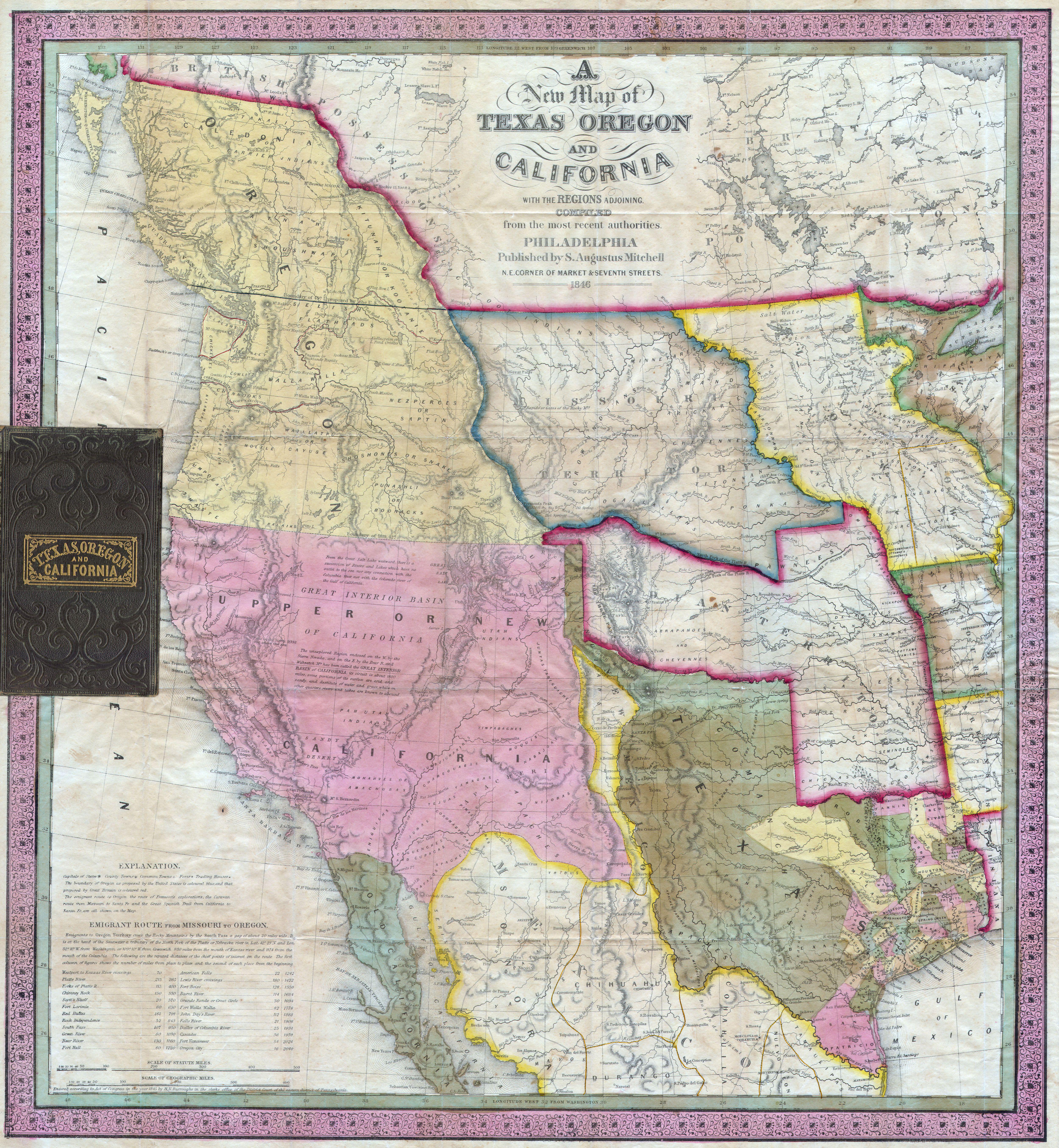
| Samuel Augustus Mitchell: A New Map of Texas, Oregon and California with the Regions Adjoining.
( |
||||||||||||||||||||
|---|---|---|---|---|---|---|---|---|---|---|---|---|---|---|---|---|---|---|---|---|
| Sanatçı/Yapan |
|
|||||||||||||||||||
| Başlık |
A New Map of Texas, Oregon and California with the Regions Adjoining. |
|||||||||||||||||||
| Açıklama |
English: A stunning example of Mitchell’s seminal 1846 pocket map of Texas, Oregon, Upper California, Missouri Territory, the Indian Territory (Oklahoma, though in this example including most of Kansas and Colorado). This important map of Texas is one of the first widely-circulated maps of the early statehood period. This map shows the borders of Texas extending to Santa Fe. Also includes Texas’ claim to the Upper Rio Grande in present day New Mexico. These claims were eventually given up in the 1850 “Great Compromise”, wherein the U.S. Federal Government assumed Texas’ public debt. To make this map Mitchell compiled the mappings of Arrowsmith (1841), Fremont, Emory, Wilkes, and Nicollet, as well as making use of data from the Louis & Clark expedition. This map was very popular when issued due to general interest in the new state of Texas as well as the Mexican-American war, which started the same year the map was issued. Brigham Young, the Mormon Moses, famously ordered six copies of this map when planning the 1847 Mormon migration west. One of the most important maps in American history. Accompanied by a 46 page text entitled Accompaniment to Mitchell’s New Map of Texas, Oregon and California, includes among the best contemporary descriptions of Oregon and California . Removed from but accompanied by the original 16mo gilt-lettered roan folder. |
|||||||||||||||||||
| Tarih | 1846 (dated) | |||||||||||||||||||
| Ebatlar | yükseklik: 22,5 in (57,1 cm); genişliği: 21 in (53,3 cm) | |||||||||||||||||||
| Katılım numarası |
Geographicus link: TXORCA-mitchell-1846 |
|||||||||||||||||||
| Kaynak/Fotoğrafçı |
|
|||||||||||||||||||
| İzin (Bu dosyanın tekrar kullanımı) |
|
|||||||||||||||||||
Dosya geçmişi
Dosyanın herhangi bir zamandaki hâli için ilgili tarih/saat kısmına tıklayın.
| Tarih/Saat | Küçük resim | Boyutlar | Kullanıcı | Yorum | |
|---|---|---|---|---|---|
| güncel | 06.23, 24 Mart 2011 | | 5.000 × 5.420 (5,64 MB) | BotMultichillT | {{subst:User:Multichill/Geographicus |link=http://www.geographicus.com/P/AntiqueMap/TXORCA-mitchell-1846 |product_name=1846 Mitchell's Map of Texas Oregon and California |map_title=A New Map of Texas, Oregon and California with the Regions Adjoining. |des |
Dosya kullanımı
Bu görüntü dosyasına bağlantısı olan sayfalar:
Küresel dosya kullanımı
Aşağıdaki diğer vikiler bu dosyayı kullanır:
- en.wikipedia.org üzerinde kullanımı
- he.wikipedia.org üzerinde kullanımı
- ru.wikipedia.org üzerinde kullanımı