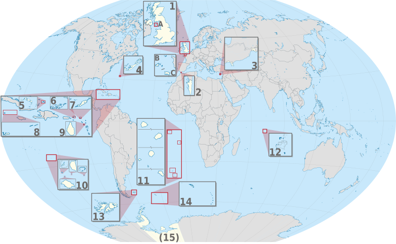
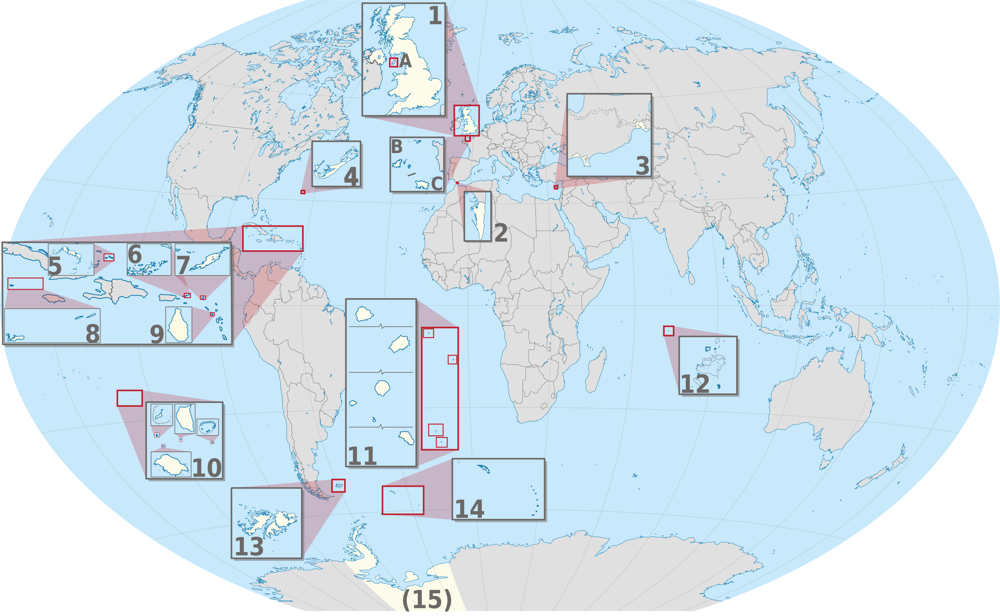
Dosya:United Kingdom (overseas+crown dependencies), administrative divisions - Nmbrs (multiple zoom).svg

Bu SVG dosyasının PNG önizlemesinin boyutu: 800 × 493 piksel. Diğer çözünürlükler: 320 × 197 piksel | 640 × 394 piksel | 1.024 × 631 piksel | 1.280 × 789 piksel | 2.560 × 1.577 piksel | 3.188 × 1.964 piksel.
Tam çözünürlük (SVG dosyası, sözde 3.188 × 1.964 piksel, dosya boyutu: 6,04 MB)
Bu dosya Wikimedia Commons'ta bulunmaktadır. Dosyanın açıklaması aşağıda gösterilmiştir. Commons, serbest/özgür telifli medya dosyalarının bulundurulduğu depodur. Siz de yardım edebilirsiniz. |
Özet


.svg)


_(Paris_zoom).svg)
.svg)
,_administrative_divisions_-_de_-_colored_(multizoom).svg)
_-_colored.svg)
.svg)
,_administrative_divisions_-_Nmbrs_(multizoom).svg)
,_administrative_divisions_-_de_-_colored.svg)
_-_de_-_colored.svg)

.svg)

.svg)
,_administrative_divisions_-_Nmbrs_(multiple_zoom).svg)
_(W3).svg)
Lisanslama
Ben, bu işin telif sahibi, burada işi aşağıdaki lisans altında yayımlıyorum:
Bu dosya, Creative Commons Atıf-Benzer Paylaşım 2.0 Genel lisansı ile lisanslanmıştır
- Şu seçeneklerde özgürsünüz:
- paylaşım – eser paylaşımı, dağıtımı ve iletimi
- içeriği değiştirip uyarlama – eser adaptasyonu
- Aşağıdaki koşullar geçerli olacaktır:
- atıf – Esere yazar veya lisans sahibi tarafından belirtilen (ancak sizi ya da eseri kullanımınızı desteklediklerini ileri sürmeyecek bir) şekilde atıfta bulunmalısınız.
- benzer paylaşım – Maddeyi yeniden karıştırır, dönüştürür veya inşa ederseniz, katkılarınızı orijinal olarak aynı veya uyumlu lisans altında dağıtmanız gerekir.

|
Yani, eğer Wikipedia veya Commons dışında kullanılan bir "Wikimedia Commons", bu medya atrribute olur. Yayınlar (örneğin, kitaplar, gazeteler, bloglar, web siteleri, vb) kullanmak için buraya Aşağıdaki satırları yerleştirin lütfen.
Lütfen eksik bilgileri doldurun. (Örnek). Lisans koşulları hala geçerli yukarıda verilmiştir. (Bu, Google tarafından otomatik bir çeviri denemesi. Lütfen bu metni geliştirmeye yardımcı olur. Sonra metin artar bu satırı kaldırın.)
|
,_administrative_divisions_-_Nmbrs_(multiple_zoom).svg)
Dosya geçmişi
Dosyanın herhangi bir zamandaki hâli için ilgili tarih/saat kısmına tıklayın.
| Tarih/Saat | Küçük resim | Boyutlar | Kullanıcı | Yorum | |
|---|---|---|---|---|---|
| güncel | 21.30, 2 Eylül 2013 | | 3.188 × 1.964 (6,04 MB) | TUBS | |
| 11.04, 20 Haziran 2012 |  | 3.188 × 1.964 (6,02 MB) | TUBS | == {{int:filedesc}} == {{Information |Description={{de|Karte der politischen Gliederung von XY (siehe Dateiname)}} {{en|Map of administrative divisions of XY (see filename)}} |Source={{own}}{{Adobe Illustrator}}{{Commonist}}{{AttribSVG|United Kingdom ... |
Dosya kullanımı
Bu görüntü dosyasına bağlantısı olan sayfalar:
Küresel dosya kullanımı
Aşağıdaki diğer vikiler bu dosyayı kullanır:
- am.wikipedia.org üzerinde kullanımı
- bn.wikipedia.org üzerinde kullanımı
- ca.wikipedia.org üzerinde kullanımı
- en.wikipedia.org üzerinde kullanımı
- en.wikivoyage.org üzerinde kullanımı
- ja.wikipedia.org üzerinde kullanımı
- or.wikipedia.org üzerinde kullanımı
- pnb.wikipedia.org üzerinde kullanımı
- pt.wikipedia.org üzerinde kullanımı
- ro.wikipedia.org üzerinde kullanımı
- uk.wikipedia.org üzerinde kullanımı
- ur.wikipedia.org üzerinde kullanımı
- vi.wikipedia.org üzerinde kullanımı
- zh.wikipedia.org üzerinde kullanımı
,_administrative_divisions_-_Nmbrs_(multiple_zoom).svg)