Dosya:The Dead Sea 1972-2011 - NASA Earth Observatory.jpg
Tam çözünürlük ((720 × 720 piksel, dosya boyutu: 240 KB, MIME tipi: image/jpeg))
Bu dosya Wikimedia Commons'ta bulunmaktadır. Dosyanın açıklaması aşağıda gösterilmiştir. Commons, serbest/özgür telifli medya dosyalarının bulundurulduğu depodur. Siz de yardım edebilirsiniz. |
Özet
| Açıklama |
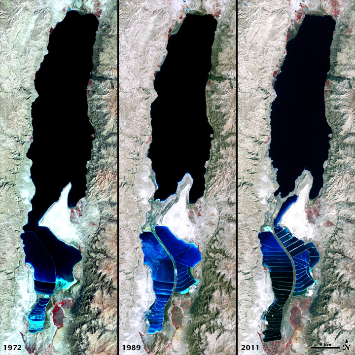
To download the full resolution and other files go to: earthobservatory.nasa.gov/IOTD/view.php?id=77592&src=... The Dead Sea is so named because its high salinity discourages the growth of fish, plants, and other wildlife. This salt lake resides in a depression in the Earth's crust, where the continents of Africa and Asia are pulling away from each other. It has pulled in visitors and industries for thousands of years. The Dead Sea is the lowest surface feature on Earth, sitting roughly 1,300 feet (400 meters) below sea level. On a hot, dry summer day, the water level can drop as much as one inch (two to three centimeters) because of evaporation. The false-color images above were captured by the Landsat 1, 4, and 7 satellites. The Multispectral Scanner System on Landsat 1 acquired the top image on September 15, 1972, by . The middle image was acquired on August 27, 1989, by the Thematic Mapper on Landsat 4. The third image is from the Enhanced Thematic Mapper Plus on Landsat 7 on October 11, 2011. All three images include a combination of near-infrared, red, and green wavelengths. Deep waters are blue or dark blue, while brighter blues indicate shallow waters or salt ponds (in the south). The pale pink and sand-colored regions are barren desert landscapes, while green indicates sparsely vegetated lands. Denser vegetation appears bright red. Near the center is the Lisan Peninsula, which forms a land bridge through the Dead Sea. The ancient Egyptians used salts from the Dead Sea for mummification, fertilizers, and potash (a potassium-based salt). In the modern age, sodium chloride and potassium salts culled from the sea are used for water conditioning, road de-icing, and the manufacturing of polyvinyl chloride (PVC) plastics. The expansion of massive salt evaporation projects are clearly visible over the span of 39 years. The region is also famous for its historical and religious significance. Between 1947 and 1956, a series of 972 ancient papyrus-and-ink texts were discovered in caverns near the sea’s northeastern shore. These “Dead Sea Scrolls” are some of the oldest preserved fragments of the Hebrew Bible and other Judeo-Christian texts. NASA and the U.S. Geological Survey (USGS) jointly manage Landsat, and the USGS preserves a 40-year archive of Landsat images that is freely available data over the Internet. The next Landsat satellite—now known as the Landsat Data Continuity Mission (LDCM)—is scheduled for launch in January 2013. NASA image by Robert Simmon, using Landsat data from the United States Geological Survey. Caption by Aries Keck and Mike Carlowicz. The Earth Observatory's mission is to share with the public the images, stories, and discoveries about climate and the environment that emerge from NASA research, including its satellite missions, in-the-field research, and climate models. Like us on Facebook Follow us on Twitter Add us to your circles on Google+ |
| Tarih | |
| Kaynak | The Dead Sea 1972-2011 |
| Yazar | NASA's Earth Observatory |
| Kamera pozisyonu | | Bu ve diğer görüntülerin konumlarını şurada belirle: OpenStreetMap |
|---|
Lisanslama
- Şu seçeneklerde özgürsünüz:
- paylaşım – eser paylaşımı, dağıtımı ve iletimi
- içeriği değiştirip uyarlama – eser adaptasyonu
- Aşağıdaki koşullar geçerli olacaktır:
- atıf – Esere yazar veya lisans sahibi tarafından belirtilen (ancak sizi ya da eseri kullanımınızı desteklediklerini ileri sürmeyecek bir) şekilde atıfta bulunmalısınız.
| This image was originally posted to Flickr by NASA Earth Observatory at https://www.flickr.com/photos/68824346@N02/7050965693. It was reviewed on 2 Temmuz 2012 by FlickreviewR and was confirmed to be licensed under the terms of the cc-by-2.0. |
Dosya geçmişi
Dosyanın herhangi bir zamandaki hâli için ilgili tarih/saat kısmına tıklayın.
| Tarih/Saat | Küçük resim | Boyutlar | Kullanıcı | Yorum | |
|---|---|---|---|---|---|
| güncel | 17.06, 2 Temmuz 2012 | | 720 × 720 (240 KB) | Dzlinker | == {{int:filedesc}} == {{Information |Description=To download the full resolution and other files go to: [http://earthobservatory.nasa.gov/IOTD/view.php?id=77592&src=flickr earthobservatory.nasa.gov/IOTD/view.php?id=77592&src=...] The Dead Sea is so n... |
Dosya kullanımı
Bu görüntü dosyasına bağlantısı olan sayfalar:
Küresel dosya kullanımı
Aşağıdaki diğer vikiler bu dosyayı kullanır:
- af.wikipedia.org üzerinde kullanımı
- ar.wikipedia.org üzerinde kullanımı
- bg.wikipedia.org üzerinde kullanımı
- de.wikipedia.org üzerinde kullanımı
- en.wikipedia.org üzerinde kullanımı
- es.wikipedia.org üzerinde kullanımı
- fr.wikipedia.org üzerinde kullanımı
- he.wikipedia.org üzerinde kullanımı
- hy.wikipedia.org üzerinde kullanımı
- hyw.wikipedia.org üzerinde kullanımı
- ro.wikipedia.org üzerinde kullanımı
- sl.wikipedia.org üzerinde kullanımı
- uk.wikipedia.org üzerinde kullanımı
- vi.wikipedia.org üzerinde kullanımı