Dosya:Special member state territories and the European Union.svg

Bu SVG dosyasının PNG önizlemesinin boyutu: 512 × 258 piksel. Diğer çözünürlükler: 320 × 161 piksel | 640 × 323 piksel | 1.024 × 516 piksel | 1.280 × 645 piksel | 2.560 × 1.290 piksel.
Tam çözünürlük (SVG dosyası, sözde 512 × 258 piksel, dosya boyutu: 835 KB)
Bu dosya Wikimedia Commons'ta bulunmaktadır. Dosyanın açıklaması aşağıda gösterilmiştir. Commons, serbest/özgür telifli medya dosyalarının bulundurulduğu depodur. Siz de yardım edebilirsiniz. |
Özet
| Açıklama |
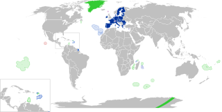
English:
European Union
Outermost regions
Overseas countries and territories
Special cases
Other special territories Français : Union européenne
Régions ultrapériphériques
Pays et territoires d'outre-mer
Cas spéciaux
Autres territoires spéciaux |
| Tarih | |
| Kaynak | Yükleyenin kendi çalışması |
| Yazar | Glentamara |
| SVG gelişimi | Bu SVG kaynak kodu geçerlidir. Bu vektörel grafik Inkscape ile oluşturuldu, or with something else. |
Lisanslama
| Ben, bu işin telif sahibi, bu işi kamu malı olarak yayınlıyorum. Bu dünya çapında geçerlidir. Bazı ülkelerde bu yasal olarak mümkün olmayabilir; öyleyse: Ben, bu işi herhangi bir amaç için, herhangi bir şart olmaksızın, yasalarca gerekli olmadıkça, herkesin kullanmasına izin veriyorum. |
Dosya geçmişi
Dosyanın herhangi bir zamandaki hâli için ilgili tarih/saat kısmına tıklayın.
| Tarih/Saat | Küçük resim | Boyutlar | Kullanıcı | Yorum | |
|---|---|---|---|---|---|
| güncel | 19.12, 8 Haziran 2022 | | 512 × 258 (835 KB) | Nablicus | new version |
| 10.13, 17 Temmuz 2020 |  | 512 × 259 (736 KB) | Alcaios | fixed – those were models I use to check the scale | |
| 23.03, 16 Temmuz 2020 |  | 512 × 258 (672 KB) | Nablicus | Reverted to version as of 19:08, 16 July 2020 (UTC). There is an extra UK and Iceland in the middle of Canada... | |
| 19.53, 16 Temmuz 2020 |  | 512 × 259 (753 KB) | Alcaios | frame | |
| 19.50, 16 Temmuz 2020 |  | 512 × 258 (681 KB) | Alcaios | minor fixed on Greenland mar. zone | |
| 19.46, 16 Temmuz 2020 |  | 512 × 258 (681 KB) | Alcaios | Added maritime zone of Gree,land based on https://www.marineregions.org/eezdetails.php?mrgid=8438 | |
| 19.32, 16 Temmuz 2020 |  | 512 × 259 (752 KB) | Alcaios | added Faroe Islands' maritime zone | |
| 19.08, 16 Temmuz 2020 |  | 512 × 258 (672 KB) | Alcaios | Maritime zones in the eastern Caribbean at the right scale, with the help of https://commons.wikimedia.org/wiki/File:Caribbean_maritime_boundaries_map.svg | |
| 18.44, 16 Temmuz 2020 |  | 512 × 259 (742 KB) | Alcaios | slight realignments | |
| 18.38, 16 Temmuz 2020 |  | 512 × 259 (742 KB) | Alcaios | typo in previous edit, read: "Northern Cyprus is not a special member state territory since..." –– the Åland archipelago is larger and almost reaches the Finnish coast |
Dosya kullanımı
Bu görüntü dosyasına bağlantısı olan sayfalar:
Küresel dosya kullanımı
Aşağıdaki diğer vikiler bu dosyayı kullanır:
- ar.wikipedia.org üzerinde kullanımı
- br.wikipedia.org üzerinde kullanımı
- cs.wikipedia.org üzerinde kullanımı
- de.wikipedia.org üzerinde kullanımı
- en.wikipedia.org üzerinde kullanımı
- European Union
- Neocolonialism
- Outline of the European Union
- Special territories of members of the European Economic Area
- Potential enlargement of the European Union
- External border of the European Union
- User:Falcaorib
- User:Xicomaia/sandbox
- User:Spinykitsune65/sandbox2
- User:A diehard editor/sandbox/EU infobox
- fa.wikipedia.org üzerinde kullanımı
- fr.wikipedia.org üzerinde kullanımı
- Aruba
- Ceuta
- Polynésie française
- Groenland
- Açores
- Saint-Pierre-et-Miquelon
- Îles Canaries
- Madère
- Îles Kerguelen
- Île Clipperton
- Îles Féroé
- Région ultrapériphérique
- Îles Éparses de l'océan Indien
- Curaçao
- Åland
- Melilla
- Archipel Crozet
- Terre Adélie
- Bonaire
- Saba
- Saint-Eustache (Antilles)
- Peñón de Vélez de la Gomera
- Peñón de Alhucemas
- Îles Saint-Paul et Amsterdam
- Plazas de soberanía
- Nouvelle-Calédonie
- Saint-Martin (royaume des Pays-Bas)
- Saint-Martin (Antilles françaises)
- Pays et territoire d'outre-mer
- Saint-Barthélemy (Antilles françaises)
- Union européenne
- États membres de l'Union européenne
- Terres australes et antarctiques françaises
Bu dosyanın daha fazla küresel kullanımını görüntüle.