Dosya:Southern ocean gravity hg.png
Bu önizlemenin boyutu: 800 × 558 piksel. Diğer çözünürlükler: 320 × 223 piksel | 640 × 447 piksel | 1.024 × 715 piksel | 1.155 × 806 piksel.
Tam çözünürlük ((1.155 × 806 piksel, dosya boyutu: 1,18 MB, MIME tipi: image/png))
Bu dosya Wikimedia Commons'ta bulunmaktadır. Dosyanın açıklaması aşağıda gösterilmiştir. Commons, serbest/özgür telifli medya dosyalarının bulundurulduğu depodur. Siz de yardım edebilirsiniz. |
| Açıklama |
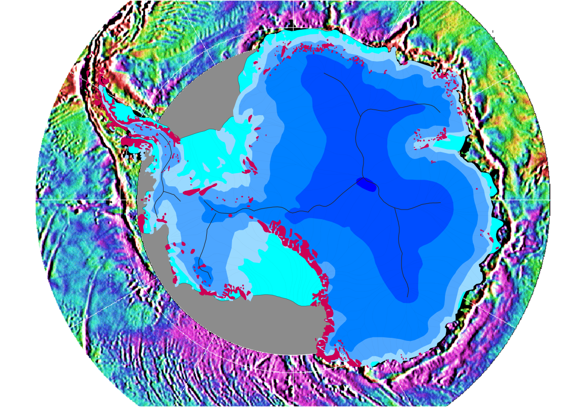
English: Gravity map of the Southern Ocean around the Antarctic continent
This gravity field was computed from sea-surface height measurements collected by the US Navy GEOSAT altimeter between March, 1985, and January, 1990. The high density GEOSAT Geodetic Mission data that lie south of 30 deg. S were declassified by the Navy in May of 1992 and contribute most of the fine-scale gravity information. The Antarctic continent itself is shaded in blue depending on the thickness of the ice sheet (blue shades in steps of 1000 m); light blue is shelf ice; gray lines are the major ice devides; pink spots are parts of the continent which are not covered by ice; gray areas have no data. Français : Carte gravimétrique de l'océan Austral et du continent antarctique Ce champ de gravité a été calculé à partir de mesures de hauteur des eaux de surface recueillies par l'altimètre de l'US Navy GEOSAT de Mars 1985 à Janvier 1990. Les données récolées par la mission "high density GEOSAT Geodetic Mission data" ont été déclassifiées par la Marine, en mai 1992 et fournissent la plupart des informations sur la gravité à petite échelle. Le continent antarctique lui-même est coloré en bleu selon l'épaisseur de la calotte glaciaire (Chaque nuances de bleu correspond à une étape de 1000 m) ; lignes grises matérialisent les bassins versants de glace; les taches roses sont les parties du continent qui ne sont pas couvertes par la glace, les zones grises sont celles pour lesquelles on manque de données |
| Tarih | |
| Kaynak | Antarctic continent: own work; gravity field: NOAA/NGDC (Marks, McAdoo & Smith) |
| Yazar | Hannes Grobe, AWI |
| İzin (Bu dosyanın tekrar kullanımı) |
Own work and public domain of NOAA |
| Diğer sürümler | Gravity data are available from the National Oceanographic Data Center, NOAA (NODC Env. Bull. 93-1); the digital gravity data shown in this image are available from the National Geophysical Data Center on the Global Relief CD-ROM (NGDC Data Announcement 93-MGG-01). See the GIF image at NGDC. |
Southern ocean gravity hg.png adlı görüntü kamu malıdır çünkü içeriği, ABD Ulusal Okyanus ve Atmosfer Dairesi (National Oceanic and Atmospheric Administration, NOAA) kökenli özgün malzeme ile ilgilidir.
|
Dosya geçmişi
Dosyanın herhangi bir zamandaki hâli için ilgili tarih/saat kısmına tıklayın.
| Tarih/Saat | Küçük resim | Boyutlar | Kullanıcı | Yorum | |
|---|---|---|---|---|---|
| güncel | 21.53, 12 Ağustos 2006 | | 1.155 × 806 (1,18 MB) | Hgrobe | {{Information| |Description=Gravity map of the Southern Ocean around the Antarctic continent |Source=own work |Date=2006-08-08 |Author=~~~~ |Permission=Own work, share alike, attribution required (Creative Commons CC-BY-SA-2.5) |other_versions= }} {{self |
Dosya kullanımı
Bu görüntü dosyasına bağlantısı olan sayfalar:
Küresel dosya kullanımı
Aşağıdaki diğer vikiler bu dosyayı kullanır:
- als.wikipedia.org üzerinde kullanımı
- ar.wikipedia.org üzerinde kullanımı
- bg.wikipedia.org üzerinde kullanımı
- ca.wikipedia.org üzerinde kullanımı
- ckb.wikipedia.org üzerinde kullanımı
- crh.wikipedia.org üzerinde kullanımı
- de.wikipedia.org üzerinde kullanımı
- el.wikipedia.org üzerinde kullanımı
- en.wikipedia.org üzerinde kullanımı
- es.wikipedia.org üzerinde kullanımı
- fa.wikipedia.org üzerinde kullanımı
- fr.wikipedia.org üzerinde kullanımı
- fy.wikipedia.org üzerinde kullanımı
- hr.wikipedia.org üzerinde kullanımı
- hu.wikipedia.org üzerinde kullanımı
- ja.wikipedia.org üzerinde kullanımı
- nl.wikipedia.org üzerinde kullanımı
- nn.wikipedia.org üzerinde kullanımı
- no.wikipedia.org üzerinde kullanımı
- pl.wikipedia.org üzerinde kullanımı
- ro.wikipedia.org üzerinde kullanımı
- sr.wikipedia.org üzerinde kullanımı
- sv.wikipedia.org üzerinde kullanımı
- te.wikipedia.org üzerinde kullanımı
- uk.wikipedia.org üzerinde kullanımı
- vi.wikipedia.org üzerinde kullanımı
- www.wikidata.org üzerinde kullanımı
- zh.wikipedia.org üzerinde kullanımı