Dosya:Somers Isles Map - John Speed 1676.jpg
Tam çözünürlük ((2.744 × 1.781 piksel, dosya boyutu: 2,86 MB, MIME tipi: image/jpeg))
Bu dosya Wikimedia Commons'ta bulunmaktadır. Dosyanın açıklaması aşağıda gösterilmiştir. Commons, serbest/özgür telifli medya dosyalarının bulundurulduğu depodur. Siz de yardım edebilirsiniz. |
Özet
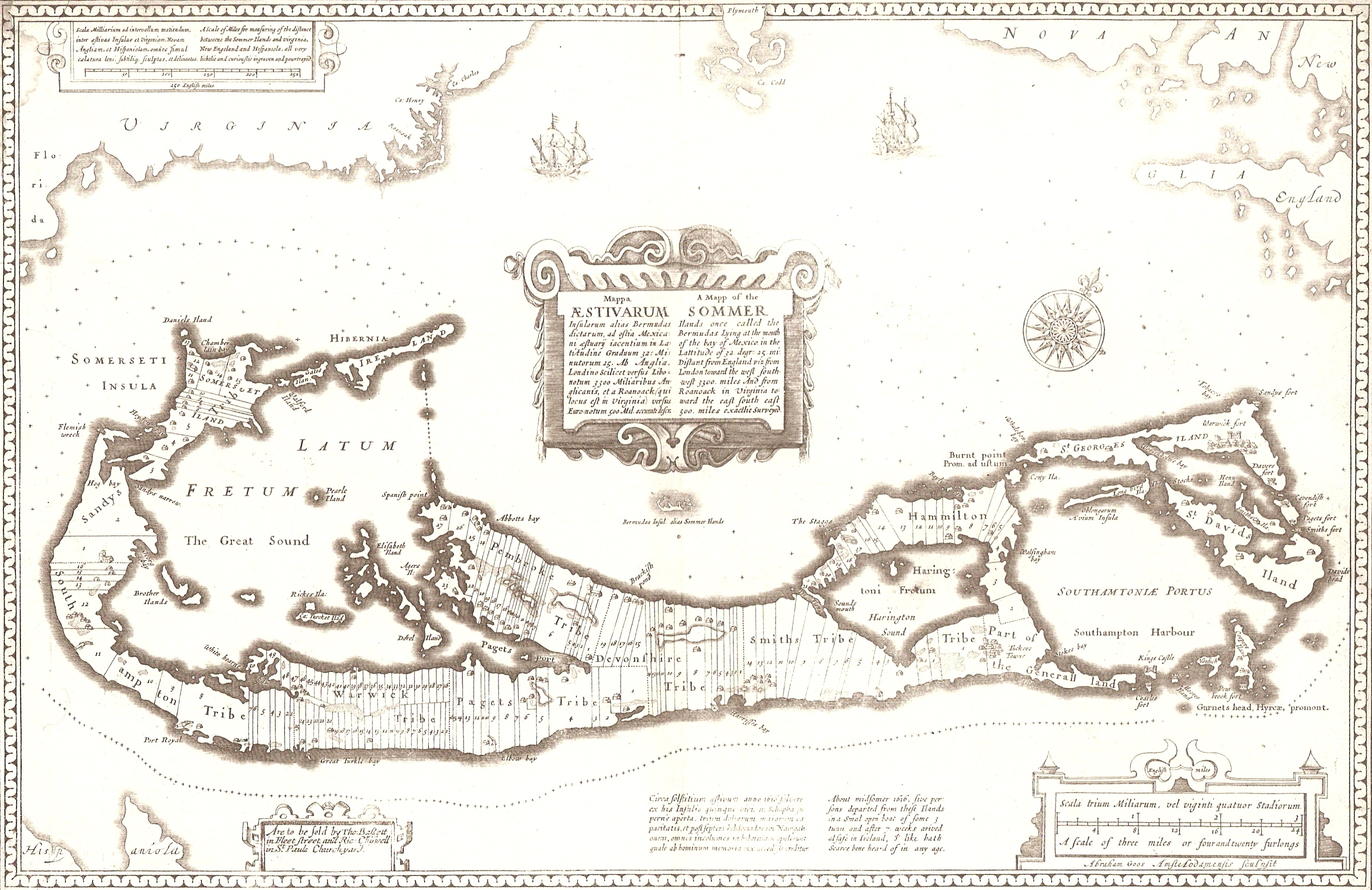
A 1676 map of the Somers Isles (alias Bermuda), by John Speed (based on the map of surveyor Richard Norwood). Clearly shown are the tribe roads cut parallel through the forest between the North and South Shores (except in St. Georges, the eastern-most subdivision, comprising the islands of St. George's and St. David's, the South-Eastern tip of the Main Island, and the various smaller islands between. This was general land, and not commercial.
Aodhdubh 06:04, 26 February 2007 (UTC)
Lisanslama
|
Bu çalışma ABD'de veya yazarın yaşamının sona ermiş olmasından 70 veya daha fazla süre geçtiğinde bu duruma uygun telif yasaları olan tüm ülkelerde kamu malıdır.
| |
| Bu dosya ve ilgili diğer hakları da dahil olmak üzere telif hakkı kapsamında bilinen tüm kısıtlamalar, serbest lisans olarak belirlenmiştir. | |
Dosya geçmişi
Dosyanın herhangi bir zamandaki hâli için ilgili tarih/saat kısmına tıklayın.
| Tarih/Saat | Küçük resim | Boyutlar | Kullanıcı | Yorum | |
|---|---|---|---|---|---|
| güncel | 06.04, 26 Şubat 2007 | | 2.744 × 1.781 (2,86 MB) | Aodhdubh | A 1676 map of the Somers Isles (alias Bermuda), by John Speed (based on the map of surveyor Richard Norwood). Clearly shown are the tribe roads cut parallel through the forest between the North and South Shores (except in St. Georges, the eastern-most sub |
Dosya kullanımı
Bu görüntü dosyasına bağlantısı olan sayfalar:
Küresel dosya kullanımı
Aşağıdaki diğer vikiler bu dosyayı kullanır:
- de.wikipedia.org üzerinde kullanımı
- en.wikipedia.org üzerinde kullanımı
- he.wikipedia.org üzerinde kullanımı