Dosya:Rakahanga.jpg
Bu önizlemenin boyutu: 509 × 600 piksel. Diğer çözünürlükler: 204 × 240 piksel | 634 × 747 piksel.
Tam çözünürlük ((634 × 747 piksel, dosya boyutu: 131 KB, MIME tipi: image/jpeg))
Bu dosya Wikimedia Commons'ta bulunmaktadır. Dosyanın açıklaması aşağıda gösterilmiştir. Commons, serbest/özgür telifli medya dosyalarının bulundurulduğu depodur. Siz de yardım edebilirsiniz. |
Özet
| Açıklama |
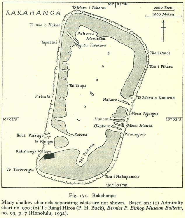
English: Map of Rakahanga Atoll, Northern Cook Islands |
| Tarih | |
| Kaynak | http://www.lib.utexas.edu/maps/historical/pacific_islands_1943_1945/rakahanga.jpg |
| Yazar | US Army |
Lisanslama
This file is in the public domain because it has been taken from a collection of public domain maps at the University of Texas Library
|
Dosya geçmişi
Dosyanın herhangi bir zamandaki hâli için ilgili tarih/saat kısmına tıklayın.
| Tarih/Saat | Küçük resim | Boyutlar | Kullanıcı | Yorum | |
|---|---|---|---|---|---|
| güncel | 17.19, 10 Ağustos 2008 | | 634 × 747 (131 KB) | Ratzer | {{Information |Description={{en|1=Map of Rakahanga Atoll, Northern Cook Islands}} |Source=http://www.lib.utexas.edu/maps/historical/pacific_islands_1943_1945/rakahanga.jpg |Author=US Army |Date=1943 |Permission= |other_versions= }} {{ImageUpload|full}} |
Dosya kullanımı
Bu görüntü dosyasına bağlantısı olan sayfalar:
Küresel dosya kullanımı
Aşağıdaki diğer vikiler bu dosyayı kullanır:
- bcl.wikipedia.org üzerinde kullanımı
- ca.wikipedia.org üzerinde kullanımı
- ceb.wikipedia.org üzerinde kullanımı
- cs.wikipedia.org üzerinde kullanımı
- de.wikipedia.org üzerinde kullanımı
- en.wikipedia.org üzerinde kullanımı
- es.wikipedia.org üzerinde kullanımı
- fr.wikipedia.org üzerinde kullanımı
- id.wikipedia.org üzerinde kullanımı
- is.wikipedia.org üzerinde kullanımı
- it.wikipedia.org üzerinde kullanımı
- ka.wikipedia.org üzerinde kullanımı
- la.wikipedia.org üzerinde kullanımı
- lt.wikipedia.org üzerinde kullanımı
- mt.wikipedia.org üzerinde kullanımı
- ru.wikipedia.org üzerinde kullanımı
- simple.wikipedia.org üzerinde kullanımı
- su.wikipedia.org üzerinde kullanımı
- sv.wikipedia.org üzerinde kullanımı
- www.wikidata.org üzerinde kullanımı