Dosya:Palouse hills northeast of Walla Walla.jpg

Bu önizlemenin boyutu: 800 × 451 piksel. Diğer çözünürlükler: 320 × 180 piksel | 640 × 361 piksel | 1.118 × 630 piksel.
Tam çözünürlük ((1.118 × 630 piksel, dosya boyutu: 589 KB, MIME tipi: image/jpeg))
Bu dosya Wikimedia Commons'ta bulunmaktadır. Dosyanın açıklaması aşağıda gösterilmiştir. Commons, serbest/özgür telifli medya dosyalarının bulundurulduğu depodur. Siz de yardım edebilirsiniz. |
| Açıklama |
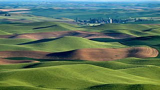
We were hearing a sound like a plane and couldn't figure out where the plane was. Finally one of us spotted a yellow plane flying in the area of the grain elevator! Amazing. Steptoe Butte is the perfect high point in the Palouse Hills to catch the shadow and light play on the hills of the area at sunset and sunrise. This is a morning capture. During one of the ice ages (about 15,000 years ago) Clark Fork River (Montana) was dammed by ice, forming Missoula Lake, the top of which was about 2,000 feet in elevation. About every 2 to 60 years there was thermal erosion of the ice dam and it would collapse and let a flood go through for about 3 days -- whatever time it took to drain Missoula Lake. Many layers of silt left by multiple Missoula floods were topped by loess (dirt blown on top) which made for great rolling hills of farmlands. |
| Tarih | |
| Kaynak | Hills, grain elevator, and little yellow plane (really) |
| Yazar | Lynn Suckow from Walla Walla, WA, USA |
Lisanslama
Bu dosya, Creative Commons Atıf-Benzer Paylaşım 2.0 Genel lisansı ile lisanslanmıştır
- Şu seçeneklerde özgürsünüz:
- paylaşım – eser paylaşımı, dağıtımı ve iletimi
- içeriği değiştirip uyarlama – eser adaptasyonu
- Aşağıdaki koşullar geçerli olacaktır:
- atıf – Esere yazar veya lisans sahibi tarafından belirtilen (ancak sizi ya da eseri kullanımınızı desteklediklerini ileri sürmeyecek bir) şekilde atıfta bulunmalısınız.
- benzer paylaşım – Maddeyi yeniden karıştırır, dönüştürür veya inşa ederseniz, katkılarınızı orijinal olarak aynı veya uyumlu lisans altında dağıtmanız gerekir.
| Özgün hali Flickr'de yayınlanan bu resim, January 13, 2009 tarihinde bir hizmetli veya lisans inceleyicisi File Upload Bot (Magnus Manske) tarafından, Flickr'da o tarihte belirtilen lisans altında yayınlandığı incelendi. |
Dosya geçmişi
Dosyanın herhangi bir zamandaki hâli için ilgili tarih/saat kısmına tıklayın.
| Tarih/Saat | Küçük resim | Boyutlar | Kullanıcı | Yorum | |
|---|---|---|---|---|---|
| güncel | 15.03, 13 Ocak 2009 | | 1.118 × 630 (589 KB) | File Upload Bot (Magnus Manske) | {{Information |Description= We were hearing a sound like a plane and couldn't figure out where the plane was. Finally one of us spotted a yellow plane flying in the area of the grain elevator! Amazing. Steptoe Butte is the perfect high point in the Pa |
Dosya kullanımı
Bu görüntü dosyasına bağlantısı olan sayfalar:
Küresel dosya kullanımı
Aşağıdaki diğer vikiler bu dosyayı kullanır:
- ar.wikipedia.org üzerinde kullanımı
- de.wikipedia.org üzerinde kullanımı
- en.wikipedia.org üzerinde kullanımı
- en.wikivoyage.org üzerinde kullanımı
- es.wikipedia.org üzerinde kullanımı
- ga.wikipedia.org üzerinde kullanımı
- hsb.wikipedia.org üzerinde kullanımı
- it.wikipedia.org üzerinde kullanımı
- it.wikibooks.org üzerinde kullanımı
- it.wikiversity.org üzerinde kullanımı
- ja.wikipedia.org üzerinde kullanımı
- nl.wikipedia.org üzerinde kullanımı
- ru.wikipedia.org üzerinde kullanımı
- simple.wikipedia.org üzerinde kullanımı
- uk.wikipedia.org üzerinde kullanımı
- vi.wikipedia.org üzerinde kullanımı