Dosya:New Zealand map.PNG
New_Zealand_map.PNG ((323 × 590 piksel, dosya boyutu: 89 KB, MIME tipi: image/png))
Bu dosya Wikimedia Commons'ta bulunmaktadır. Dosyanın açıklaması aşağıda gösterilmiştir. Commons, serbest/özgür telifli medya dosyalarının bulundurulduğu depodur. Siz de yardım edebilirsiniz. |
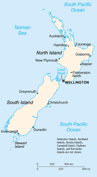
A map of New Zealand showing the major cities and towns. Not shown are the Antipodes Islands, Auckland Islands, Bounty Islands, Campbell Island, The Snares, and the Kermadec Islands.
https://www.cia.gov/library/publications/the-world-factbook/geos/nz.html archive copy at the Wayback Machine
It should be noted that the scale on this map is not accurate. Measuring distances on the map then using the scale to determine those distances on the ground would lead to considerable exaggeration of those distances. This issue has been raised with the CIA, who compile these World Fact Book maps.
- Update - the latest version updated by Grutness is much better. Please see the Talk page for more.
ABD Merkezi İstihbarat Teşkilatı'nın World Factbook'tan gelen malzemeler içerdiğinden bu görüntü kamu malıdır.
|
 |
Dosya geçmişi
Dosyanın herhangi bir zamandaki hâli için ilgili tarih/saat kısmına tıklayın.
| Tarih/Saat | Küçük resim | Boyutlar | Kullanıcı | Yorum | |
|---|---|---|---|---|---|
| güncel | 01.14, 30 Temmuz 2005 | | 323 × 590 (89 KB) | Grutness | scale corrected |
| 01.04, 30 Temmuz 2005 |  | 323 × 590 (100 KB) | Grutness | Scale corrected | |
| 04.24, 6 Mayıs 2005 |  | 323 × 590 (21 KB) | Evil Monkey | World Factbook map cropped and modified but still PD |
Dosya kullanımı
Bu görüntü dosyasına bağlantısı olan sayfalar:
Küresel dosya kullanımı
Aşağıdaki diğer vikiler bu dosyayı kullanır:
- an.wikipedia.org üzerinde kullanımı
- bbc.wikipedia.org üzerinde kullanımı
- be-tarask.wikipedia.org üzerinde kullanımı
- br.wikipedia.org üzerinde kullanımı
- bs.wikipedia.org üzerinde kullanımı
- cs.wikipedia.org üzerinde kullanımı
- de.wikipedia.org üzerinde kullanımı
- de.wikinews.org üzerinde kullanımı
- en.wikipedia.org üzerinde kullanımı
- en.wiktionary.org üzerinde kullanımı
- es.wikinews.org üzerinde kullanımı
- eu.wikipedia.org üzerinde kullanımı
- fr.wikipedia.org üzerinde kullanımı
- fr.wiktionary.org üzerinde kullanımı
- gd.wikipedia.org üzerinde kullanımı
- gl.wikipedia.org üzerinde kullanımı
- he.wikipedia.org üzerinde kullanımı
- hi.wikipedia.org üzerinde kullanımı
- hr.wikipedia.org üzerinde kullanımı
- io.wikipedia.org üzerinde kullanımı
- it.wikipedia.org üzerinde kullanımı
- ka.wikipedia.org üzerinde kullanımı
- la.wikipedia.org üzerinde kullanımı
- lt.wikipedia.org üzerinde kullanımı
- ml.wikipedia.org üzerinde kullanımı
- mr.wikipedia.org üzerinde kullanımı
- nds-nl.wikipedia.org üzerinde kullanımı
- nl.wikipedia.org üzerinde kullanımı
- nn.wikipedia.org üzerinde kullanımı
- no.wikipedia.org üzerinde kullanımı
- pl.wikipedia.org üzerinde kullanımı
- pl.wikibooks.org üzerinde kullanımı
- pl.wikivoyage.org üzerinde kullanımı
- pt.wikipedia.org üzerinde kullanımı
- ru.wikipedia.org üzerinde kullanımı
- ru.wikinews.org üzerinde kullanımı
- sr.wikipedia.org üzerinde kullanımı
- sv.wikipedia.org üzerinde kullanımı
Bu dosyanın daha fazla küresel kullanımını görüntüle.