Dosya:McKinney Stables, Cuba, New York - 20200719.jpg
Bu önizlemenin boyutu: 800 × 480 piksel. Diğer çözünürlükler: 320 × 192 piksel | 1.024 × 614 piksel | 1.280 × 768 piksel | 2.560 × 1.536 piksel | 3.747 × 2.248 piksel.
Tam çözünürlük ((3.747 × 2.248 piksel, dosya boyutu: 2,52 MB, MIME tipi: image/jpeg))
Bu dosya Wikimedia Commons'ta bulunmaktadır. Dosyanın açıklaması aşağıda gösterilmiştir. Commons, serbest/özgür telifli medya dosyalarının bulundurulduğu depodur. Siz de yardım edebilirsiniz. |
Özet
| Açıklama |
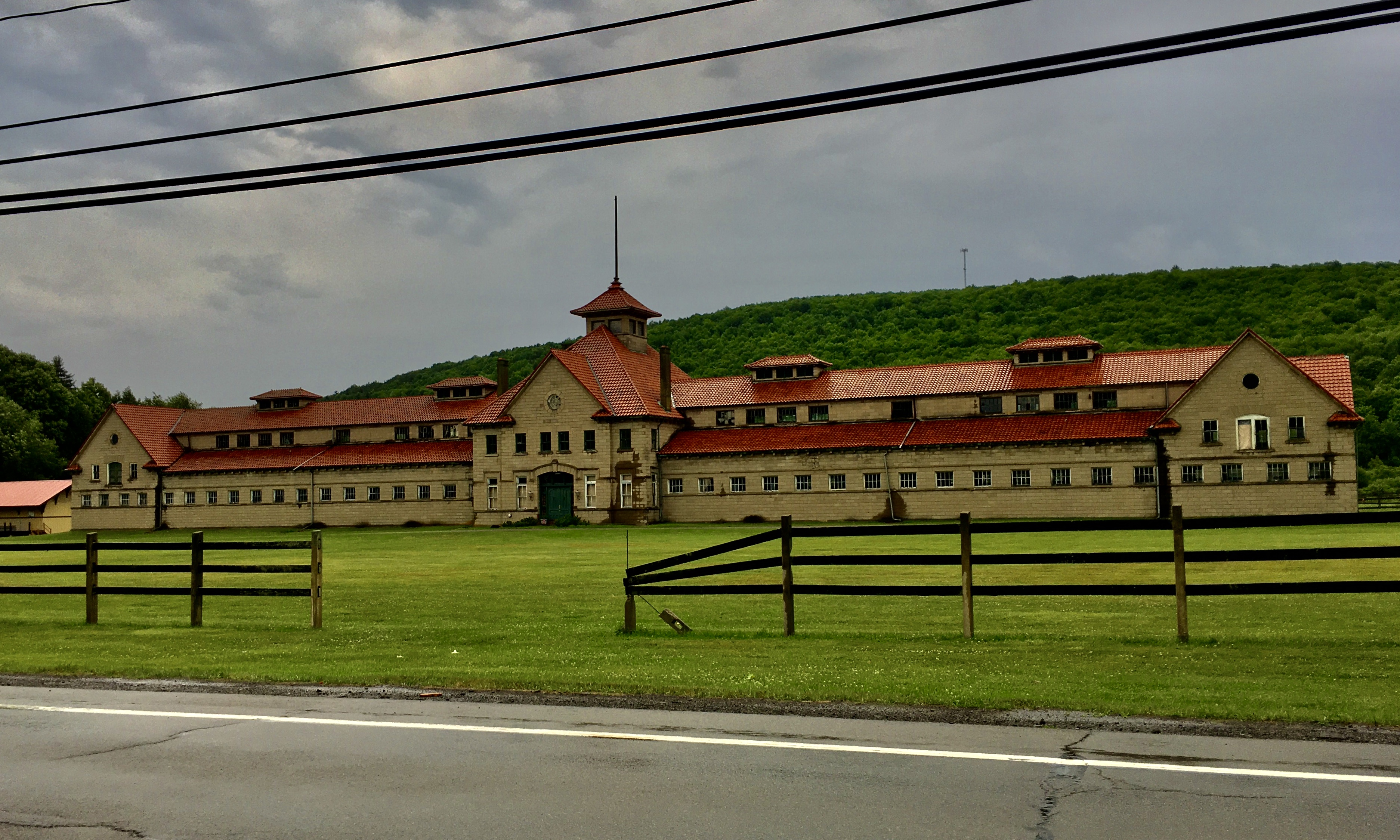
English: The McKinney Stables of Empire City Farms, 105 South Street, Cuba, New York, July 2020. A work of Buffalo-based architect John H. Coxhead, this enormous horse barn extends 347 feet in length and was constructed of concrete blocks produced on-site via an innovative casting process, accented with concrete trim, and topped with a steeply-pitched hip roof in terra cotta tile lending something of a Mediterranean influence. Notable among its architectural features are the identical gables above the entrance and atop the pavilion at the end of each wing, with prominent cornice returns at the bottom of each eave and an oculus window contained within, as well as the segmental-arched architrave above the main entrance topped with a decorative keystone, and the cupola with an unusual pagoda-like roof that crowns the façade at center. Locally renowned as a breeder of Jersey cattle and novel Shetland ponies, the enormous Empire City Farms was located in the neighboring town of New Hudson and was owned by Joseph McGraw (1812-1892) and his son-in-law William Simpson (1837-1916), the latter of whom was an avid aficionado of horse racing and had the stable seen here built in 1909 to house his prize racehorses after the stables at New Hudson were lost to a devastating fire five years earlier. The 99 acres of land on which the building sits were used for grazing and exercising the horses. After the sale of Empire City Farms a few years after Simpson's death, the building was used for a short period as the home of the printing business owned by son Frederick Simpson (1873-1956), and also for a short period in the 1980s saw use for its originally intended purpose housing Arabian stallions, but has otherwise stood vacant for most of the past century. |
| Tarih | Taken on 19 Temmuz 2020, 16:45:01 |
| Kaynak | Yükleyenin kendi çalışması |
| Yazar | Andre Carrotflower |
| Kamera pozisyonu | | Bu ve diğer görüntülerin konumlarını şurada belirle: OpenStreetMap |
|---|
Lisanslama
Ben, bu işin telif sahibi, burada işi aşağıdaki lisans altında yayımlıyorum:
Bu dosya, Creative Commons Atıf-Benzer Paylaşım 4.0 Uluslararası lisansı ile lisanslanmıştır.
- Şu seçeneklerde özgürsünüz:
- paylaşım – eser paylaşımı, dağıtımı ve iletimi
- içeriği değiştirip uyarlama – eser adaptasyonu
- Aşağıdaki koşullar geçerli olacaktır:
- atıf – Esere yazar veya lisans sahibi tarafından belirtilen (ancak sizi ya da eseri kullanımınızı desteklediklerini ileri sürmeyecek bir) şekilde atıfta bulunmalısınız.
- benzer paylaşım – Maddeyi yeniden karıştırır, dönüştürür veya inşa ederseniz, katkılarınızı orijinal olarak aynı veya uyumlu lisans altında dağıtmanız gerekir.
Dosya geçmişi
Dosyanın herhangi bir zamandaki hâli için ilgili tarih/saat kısmına tıklayın.
| Tarih/Saat | Küçük resim | Boyutlar | Kullanıcı | Yorum | |
|---|---|---|---|---|---|
| güncel | 05.52, 5 Ağustos 2020 | | 3.747 × 2.248 (2,52 MB) | Andre Carrotflower | Uploaded own work with UploadWizard |
Dosya kullanımı
Bu görüntü dosyasına bağlanan sayfa yok.
Küresel dosya kullanımı
Aşağıdaki diğer vikiler bu dosyayı kullanır:
- en.wikipedia.org üzerinde kullanımı
- www.wikidata.org üzerinde kullanımı