Dosya:Mapa de los Estados Unidos de Colombia (1864).jpg

Tam çözünürlük ((3.660 × 2.974 piksel, dosya boyutu: 2,89 MB, MIME tipi: image/jpeg))
Bu dosya Wikimedia Commons'ta bulunmaktadır. Dosyanın açıklaması aşağıda gösterilmiştir. Commons, serbest/özgür telifli medya dosyalarının bulundurulduğu depodur. Siz de yardım edebilirsiniz. |
.jpg)
Özet
| Açıklama |
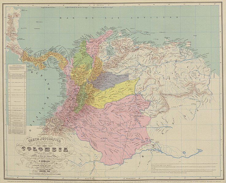
Español: Carta Jeográfica de los Estados Unidos de Colombia. Tomado del "Atlas geográfico e histórico de la República de Colombia", 1890 y el "Atlas de Colombia", 1967 |
||||
| Tarih | |||||
| Kaynak |
Atlas geográfico e histórico de la República de Colombia, 1890 http://www.lablaa.org/blaavirtual/faunayflora/orinoco/orinoco9a.htm http://www.revistacredencial.com/credencial_historia/atlas/home_atlas.htm |
||||
| Yazar | Agustín Codazzi, Manuel Maria Paz, Felipe Pérez | ||||
| İzin (Bu dosyanın tekrar kullanımı) |
|
||||
Dosya geçmişi
Dosyanın herhangi bir zamandaki hâli için ilgili tarih/saat kısmına tıklayın.
| Tarih/Saat | Küçük resim | Boyutlar | Kullanıcı | Yorum | |
|---|---|---|---|---|---|
| güncel | 06.14, 1 Mayıs 2021 | | 3.660 × 2.974 (2,89 MB) | Milenioscuro | resolución |
| 20.59, 10 Ocak 2011 |  | 720 × 560 (145 KB) | Milenioscuro | mapa con mejores colores y mas nitido | |
| 05.01, 27 Ekim 2010 |  | 591 × 473 (57 KB) | Milenioscuro | Reverted to version as of 17:24, 5 August 2008 | |
| 01.48, 5 Nisan 2010 |  | 582 × 450 (224 KB) | Milenioscuro | mapa con mejor resolución | |
| 17.24, 5 Ağustos 2008 |  | 591 × 473 (57 KB) | Milenioscuro | {{Information |Description={{es|1=Estados Unidos de Colombia. Tomado del "Atlas histórico y geográfico de Colombia", 1890.}} |Source=http://www.lablaa.org/blaavirtual/faunayflora/orinoco/orinoco9a.htm |Author=Agustin Codazzi |Date=1890 |Permission= |oth |
Dosya kullanımı
Bu görüntü dosyasına bağlantısı olan sayfalar:
Küresel dosya kullanımı
Aşağıdaki diğer vikiler bu dosyayı kullanır:
- de.wikisource.org üzerinde kullanımı
- el.wikipedia.org üzerinde kullanımı
- en.wikipedia.org üzerinde kullanımı
- es.wikipedia.org üzerinde kullanımı
- fr.wikipedia.org üzerinde kullanımı
- id.wikipedia.org üzerinde kullanımı
- it.wikipedia.org üzerinde kullanımı
- pt.wikipedia.org üzerinde kullanımı
.jpg)