Dosya:Maldives.visibleearth.nasa.jpg

Bu önizlemenin boyutu: 466 × 599 piksel. Diğer çözünürlükler: 187 × 240 piksel | 373 × 480 piksel | 597 × 768 piksel | 796 × 1.024 piksel | 1.400 × 1.800 piksel.
Tam çözünürlük ((1.400 × 1.800 piksel, dosya boyutu: 530 KB, MIME tipi: image/jpeg))
Bu dosya Wikimedia Commons'ta bulunmaktadır. Dosyanın açıklaması aşağıda gösterilmiştir. Commons, serbest/özgür telifli medya dosyalarının bulundurulduğu depodur. Siz de yardım edebilirsiniz. |

|
This map has been uploaded by Electionworld from en.wikipedia.org to enable the |
Özet
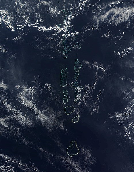
Source: http://visibleearth.nasa.gov
It should be noted that the southern most Atoll of the Maldives, Addu Atoll, is not visible on this image.
Lisanslama
| Bu dosya NASA tarafından üretildiği için kamu malıdır. Aksi belirtilmediği sürece "NASA tarafından üretilen malzemenin telif hakkı olmadığı" NASA telif politikasında belirtilmiştir. (Bkz. Template:PD-USGov, NASA copyright policy page veya JPL Image Use Policy.) | ||
 |
Uyarılar:
|
Dosya geçmişi
Dosyanın herhangi bir zamandaki hâli için ilgili tarih/saat kısmına tıklayın.
| Tarih/Saat | Küçük resim | Boyutlar | Kullanıcı | Yorum | |
|---|---|---|---|---|---|
| güncel | 22.52, 27 Kasım 2006 | | 1.400 × 1.800 (530 KB) | Electionworld | {{ew|en|Oblivious}} == Summary == '''Source:''' [http://veimages.gsfc.nasa.gov/2686/Maldives.A2002090.0525.500m.jpg http://visibleearth.nasa.gov] It should be noted that the southern most Atoll of the Maldives, Addu Atoll, is not visible on this ima |
Dosya kullanımı
Bu görüntü dosyasına bağlantısı olan sayfalar:
Küresel dosya kullanımı
Aşağıdaki diğer vikiler bu dosyayı kullanır:
- af.wikipedia.org üzerinde kullanımı
- ar.wikipedia.org üzerinde kullanımı
- en.wikipedia.org üzerinde kullanımı
- gl.wikipedia.org üzerinde kullanımı
- hi.wikipedia.org üzerinde kullanımı
- it.wikipedia.org üzerinde kullanımı
- kn.wikipedia.org üzerinde kullanımı
- lt.wikipedia.org üzerinde kullanımı
- mk.wikipedia.org üzerinde kullanımı
- ml.wikipedia.org üzerinde kullanımı
- my.wikipedia.org üzerinde kullanımı
- pl.wikipedia.org üzerinde kullanımı
- sd.wikipedia.org üzerinde kullanımı
- sr.wikipedia.org üzerinde kullanımı
- ta.wikipedia.org üzerinde kullanımı
- th.wikipedia.org üzerinde kullanımı
- trv.wikipedia.org üzerinde kullanımı
- uk.wikipedia.org üzerinde kullanımı
- vi.wikipedia.org üzerinde kullanımı
- zh.wikipedia.org üzerinde kullanımı