Dosya:Knowledge of German EU map (2010).svg
Tam çözünürlük(SVG dosyası, sözde 590 × 603 piksel, dosya boyutu: 670 KB)


Özet

Açıklama
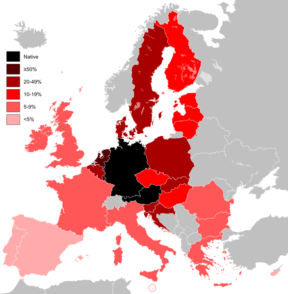
English: Knowledge of German language in countries of the European Union.
Deutsch: Kenntnisse der deutschen Sprache in Ländern der Europäischen Union.
Français : Carte des connaissances de l'allemand dans l'Union européenne.
Polski: Znajomość języka niemieckiego w krajach Unii Europejskiej.
Tarih (UTC)
Kaynak

Knowledge of German EU map.png

Yazar
Diğer sürümler Knowledge of Spanish EU map.svg
SVG gelişimi
InfoField
 
Bu SVG kaynak kodu geçerlidir.
 
Bu vektörel grafik Inkscape ile oluşturuldu, or with something else.
Bu rötuşlanmış bir resim olup, resmin özgün hâli üzerinde oynama yapılarak elde edilmiştir. Yapılan değişiklikler: Vectorised German map (based on vector map of EU/UK).Resmin özgün hâline şuradan erişilebilir: EU-United Kingdom.svg. Resimdeki düzenlemeler Alphathon tarafından yapılmıştır.

This image is an information graphic created by a computer program from data sets or formulas that have not been fully provided on this page. In order to allow other editors to improve or build such images, and to ensure compliance with free content licenses such as the GFDL, the following should be provided:
  • Software package(s) used
  • Data sets used (if any), including pre-processing instructions
  • Sequence of commands used to create the graphic
  • Short description of any post-processing stages
Once all the above are included in the image's description page(s), please remove this template.

Deutsch  English  français  magyar  Nederlands  Plattdüütsch  suomi  македонски  русский  日本語  中文  中文(简体)‎  +/−

Lisanslama

w:tr:Creative Commons
atıf benzer paylaşım
Bu dosya, Creative Commons Atıf-Benzer Paylaşım 3.0 Taşınmamış lisansı ile lisanslanmıştır
Şu seçeneklerde özgürsünüz:
  • paylaşım – eser paylaşımı, dağıtımı ve iletimi
  • içeriği değiştirip uyarlama – eser adaptasyonu
Aşağıdaki koşullar geçerli olacaktır:
  • atıf – Esere yazar veya lisans sahibi tarafından belirtilen (ancak sizi ya da eseri kullanımınızı desteklediklerini ileri sürmeyecek bir) şekilde atıfta bulunmalısınız.
  • benzer paylaşım – Maddeyi yeniden karıştırır, dönüştürür veya inşa ederseniz, katkılarınızı orijinal olarak aynı veya uyumlu lisans altında dağıtmanız gerekir.

Orijinal yükleme günlüğü

This image is a derivative work of the following images:

  • Knowledge of German EU map.png licensed with PD-self
    • 2009-05-23T22:36:14Z HernauMan 1218x1245 (56214 Bytes) {{Information |Description={{en|1=Knowledge of German language in EU with Bosnia and Herzegovina, Switzerland and Turkey. }} |Source=Own work by uploader |Author=[[User:HernauMan|HernauMan]] |Date=2009-05-15 |Permiss
  • EU-United Kingdom.svg licensed with Cc-by-sa-3.0, GFDL
    • 2009-10-23T15:07:42Z NuclearVacuum 2045x1720 (2732281 Bytes) fixing glitch
    • 2009-10-23T14:55:55Z NuclearVacuum 2045x1720 (2732292 Bytes) consensus version
    • 2009-10-20T17:19:31Z NuclearVacuum 2045x1720 (2732278 Bytes) green version
    • 2009-10-18T03:50:51Z NuclearVacuum 2045x1720 (2743430 Bytes) Brand new version as part of an agreement.
    • 2009-10-17T17:30:24Z NuclearVacuum 680x520 (541798 Bytes) new version, removed Isle of Mans
    • 2009-10-17T05:10:16Z NuclearVacuum 680x520 (538943 Bytes) red coloring
    • 2009-10-16T16:11:11Z NuclearVacuum 680x520 (538943 Bytes) minor
    • 2009-10-16T15:34:20Z NuclearVacuum 680x520 (538943 Bytes) {{Information |Description={{en|1={{EU SVG}}}} |Source=*[[:File:Blank map europe.svg]]{{Inkscape}} |Author=[[User:NuclearVacuum|NuclearVacuum]] |Date=2009-10 |Permission= |other_versions=*[[:File:Location UK EU Europe.png]] }

Uploaded with derivativeFX

Altyazılar

Bu dosyanın temsil ettiği şeyin tek satırlık açıklamasını ekleyin.

Bu dosyada gösterilen öğeler

betimlenen

27 Ağustos 2010

Dosya geçmişi

Dosyanın herhangi bir zamandaki hâli için ilgili tarih/saat kısmına tıklayın.

(en yeni | en eski) (10 daha yeni) () (10 | 20 | 50 | 100 | 250 | 500)
Tarih/SaatKüçük resimBoyutlarKullanıcıYorum
güncel16.07, 15 Mayıs 202316.07, 15 Mayıs 2023 tarihindeki sürümün küçültülmüş hâli590 × 603 (670 KB)SaippuakauppiasReverted to version as of 18:26, 4 February 2017 (UTC): UK was included in the census (2010), we don't need to remove data, because politics changed.
10.47, 3 Şubat 202010.47, 3 Şubat 2020 tarihindeki sürümün küçültülmüş hâli590 × 603 (670 KB)Darrancremove UK from EU
18.26, 4 Şubat 201718.26, 4 Şubat 2017 tarihindeki sürümün küçültülmüş hâli590 × 603 (670 KB)Gabriel HMReverted to version as of 22:09, 16 February 2015 (UTC), common sense, german is not the native language in the plain of Alsace.
15.54, 11 Kasım 201515.54, 11 Kasım 2015 tarihindeki sürümün küçültülmüş hâli1.212 × 1.242 (538 KB)RasmusIhermannReverted to version as of 15:52, 11 November 2015 (UTC)
15.53, 11 Kasım 201515.53, 11 Kasım 2015 tarihindeki sürümün küçültülmüş hâli1.212 × 1.242 (538 KB)RasmusIhermannReverted to version as of 13:18, 28 August 2013 (UTC)
15.52, 11 Kasım 201515.52, 11 Kasım 2015 tarihindeki sürümün küçültülmüş hâli1.212 × 1.242 (538 KB)RasmusIhermannReverted to version as of 13:18, 28 August 2013 (UTC)
22.09, 16 Şubat 201522.09, 16 Şubat 2015 tarihindeki sürümün küçültülmüş hâli590 × 603 (670 KB)LeftcryFix layout and update information
13.18, 28 Ağustos 201313.18, 28 Ağustos 2013 tarihindeki sürümün küçültülmüş hâli1.212 × 1.242 (538 KB)MichaelM777added Switzerland and Bosnia-Herzegowina again and deleted 2 non-existant german "lakes"
12.42, 28 Ağustos 201312.42, 28 Ağustos 2013 tarihindeki sürümün küçültülmüş hâli1.212 × 1.242 (538 KB)MichaelM777Reverted to version as of 21:27, 5 March 2011
19.54, 6 Eylül 201119.54, 6 Eylül 2011 tarihindeki sürümün küçültülmüş hâli1.212 × 1.242 (539 KB)TreehillI deleted Switzerland and Bosnia which are neither in the EU nor candidate countries.
(en yeni | en eski) (10 daha yeni) () (10 | 20 | 50 | 100 | 250 | 500)

Bu görüntü dosyasına bağlantısı olan sayfalar:

Küresel dosya kullanımı

Aşağıdaki diğer vikiler bu dosyayı kullanır:

Bu dosyanın daha fazla küresel kullanımını görüntüle.

Meta veri