Dosya:Jakarta Skyline Part 2.jpg

Tam çözünürlük ((1.546 × 768 piksel, dosya boyutu: 801 KB, MIME tipi: image/jpeg))
Bu dosya Wikimedia Commons'ta bulunmaktadır. Dosyanın açıklaması aşağıda gösterilmiştir. Commons, serbest/özgür telifli medya dosyalarının bulundurulduğu depodur. Siz de yardım edebilirsiniz. |

|
Copyright warning: A subject in this image is protected by copyright.
This image features an architectural or artistic work, photographed from a public space in Indonesia. There are no freedom of panorama exceptions of any kind under the Chapter VI (Copyright Limitations), Articles 43–51 of the Indonesian Copyright Act No. 28, 2014, which means that these architectural or artistic works cannot be photographed freely for anything other than non-commercial or personal uses. If a copyrighted architectural or artistic work is contained in this image and it is a substantial reproduction, this photo cannot be licensed under a free license, and will be deleted. Framing this image to focus on the copyrighted work is also a copyright violation. Before reusing this content, ensure that you have the right to do so. You are solely responsible for ensuring that you do not infringe someone else's copyrights. See our general disclaimer for more information. |

Özet
| Açıklama |
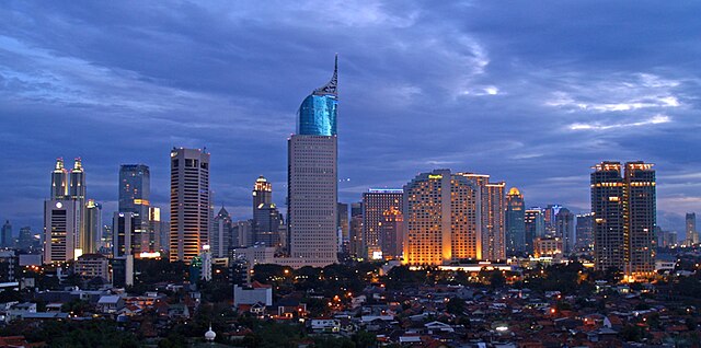
English: Lining up Jakarta's skyscrapers along the CBD with Wisma 46 as the centerpiece.
Wisma 46 is designed by Zeidler Partnership and has been well-known for being Indonesia's tallest building; and Jakarta's most distinguished skyscrapers with its unique shape resembling an elegant fountain pen. Singapore may have a "Durian" (The Esplanade); and Beijing has a "Bird's Nest" (Olympic Stadium) and "Trousers Pants" (CCTV Tower); but Jakarta has an elegant "Fountain Pen". Although it may not be the tallest building in Indonesia now, -with the completion of Menara BCA and The Kempinski Residences at the Grand Indonesia Mall complex; and construction at The Jakarta Tower (558m) is coming soon-, Wisma 46 remains one of the nation's most distinguished and unique building. |
| Tarih | |
| Kaynak | https://www.flickr.com/photos/joe-joe/2303992129/ |
| Yazar | yohanes budiyanto |
| Nesne pozisyonu | | Bu ve diğer görüntülerin konumlarını şurada belirle: OpenStreetMap |
|---|
Lisanslama
- Şu seçeneklerde özgürsünüz:
- paylaşım – eser paylaşımı, dağıtımı ve iletimi
- içeriği değiştirip uyarlama – eser adaptasyonu
- Aşağıdaki koşullar geçerli olacaktır:
- atıf – Esere yazar veya lisans sahibi tarafından belirtilen (ancak sizi ya da eseri kullanımınızı desteklediklerini ileri sürmeyecek bir) şekilde atıfta bulunmalısınız.
| This image was originally posted to Flickr by yohanes budiyanto at https://www.flickr.com/photos/27228523@N00/2303992129. It was reviewed on 20 Aralık 2009 by FlickreviewR and was confirmed to be licensed under the terms of the cc-by-2.0. |
Dosya geçmişi
Dosyanın herhangi bir zamandaki hâli için ilgili tarih/saat kısmına tıklayın.
| Tarih/Saat | Küçük resim | Boyutlar | Kullanıcı | Yorum | |
|---|---|---|---|---|---|
| güncel | 21.45, 3 Mayıs 2023 | | 1.546 × 768 (801 KB) | B18IDH | Maybe This Is More Correct? |
| 19.05, 19 Aralık 2009 |  | 906 × 450 (519 KB) | Rochelimit | {{Information |Description={{en|1=Lining up Jakarta's skyscrapers. I took similar picture before with my Leica. This time, I tried it with my E-500 when the setting is blue, unlike previously in magenta. I'm also trying the 'golden rule' where the most pr |
Dosya kullanımı
Bu görüntü dosyasına bağlantısı olan sayfalar:
Küresel dosya kullanımı
Aşağıdaki diğer vikiler bu dosyayı kullanır:
- ar.wikipedia.org üzerinde kullanımı
- arz.wikipedia.org üzerinde kullanımı
- ast.wikipedia.org üzerinde kullanımı
- azb.wikipedia.org üzerinde kullanımı
- ban.wikipedia.org üzerinde kullanımı
- ba.wikipedia.org üzerinde kullanımı
- bjn.wikipedia.org üzerinde kullanımı
- blk.wikipedia.org üzerinde kullanımı
- bn.wikipedia.org üzerinde kullanımı
- bn.wikibooks.org üzerinde kullanımı
- bs.wikipedia.org üzerinde kullanımı
- bug.wikipedia.org üzerinde kullanımı
- bxr.wikipedia.org üzerinde kullanımı
- ceb.wikipedia.org üzerinde kullanımı
- ckb.wikipedia.org üzerinde kullanımı
- crh.wikipedia.org üzerinde kullanımı
- csb.wikipedia.org üzerinde kullanımı
- cu.wikipedia.org üzerinde kullanımı
- cy.wikipedia.org üzerinde kullanımı
- dag.wikipedia.org üzerinde kullanımı
- de.wikipedia.org üzerinde kullanımı
- diq.wikipedia.org üzerinde kullanımı
- dv.wikipedia.org üzerinde kullanımı
- en.wikipedia.org üzerinde kullanımı
- en.wikivoyage.org üzerinde kullanımı
- eo.wikipedia.org üzerinde kullanımı
- es.wikipedia.org üzerinde kullanımı
- eu.wikipedia.org üzerinde kullanımı
- fa.wikipedia.org üzerinde kullanımı
Bu dosyanın daha fazla küresel kullanımını görüntüle.