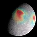
Dosya:Gravity Anomalies on Mercury.jpg

Bu önizlemenin boyutu: 600 × 600 piksel. Diğer çözünürlükler: 240 × 240 piksel | 480 × 480 piksel | 768 × 768 piksel | 1.024 × 1.024 piksel | 2.400 × 2.400 piksel.
Tam çözünürlük ((2.400 × 2.400 piksel, dosya boyutu: 1,03 MB, MIME tipi: image/jpeg))
Dosya geçmişi
Dosyanın herhangi bir zamandaki hâli için ilgili tarih/saat kısmına tıklayın.
| Tarih/Saat | Küçük resim | Boyutlar | Kullanıcı | Yorum | |
|---|---|---|---|---|---|
| güncel | 20.15, 11 Şubat 2019 |  | 2.400 × 2.400 (1,03 MB) | Huntster | Cropped 20 % vertically using CropTool with precise mode. |
| 12.33, 4 Aralık 2015 |  | 2.400 × 3.000 (1.011 KB) | PlanetUser | {{Information |Description ={{en|1=Analysis of radio tracking data have enabled maps of the gravity field of Mercury to be derived. In this image, overlain on a mosaic obtained by MESSENGER's Mercury Dual Imaging System and illuminated with a shape... |
Dosya kullanımı
Bu görüntü dosyasına bağlantısı olan sayfalar:
Küresel dosya kullanımı
Aşağıdaki diğer vikiler bu dosyayı kullanır:
- azb.wikipedia.org üzerinde kullanımı
- az.wikipedia.org üzerinde kullanımı
- da.wikipedia.org üzerinde kullanımı
- en.wikipedia.org üzerinde kullanımı
- en.wikiversity.org üzerinde kullanımı
- eu.wikipedia.org üzerinde kullanımı
- ja.wikipedia.org üzerinde kullanımı
- mk.wikipedia.org üzerinde kullanımı
- pt.wikipedia.org üzerinde kullanımı
- uk.wikipedia.org üzerinde kullanımı

