Dosya:CarlSaxET1877.jpg
Tam çözünürlük ((3.100 × 2.968 piksel, dosya boyutu: 7,57 MB, MIME tipi: image/jpeg))
Bu dosya Wikimedia Commons'ta bulunmaktadır. Dosyanın açıklaması aşağıda gösterilmiştir. Commons, serbest/özgür telifli medya dosyalarının bulundurulduğu depodur. Siz de yardım edebilirsiniz. |
Özet
| Açıklama |
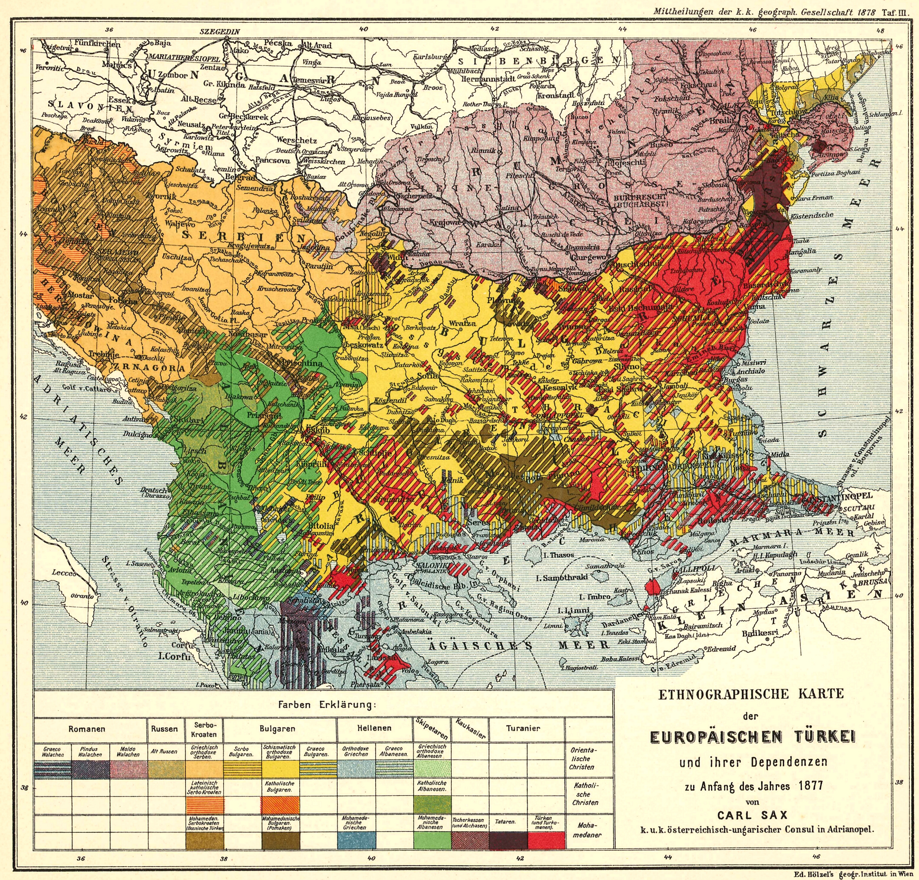
English: Ethnological Map of European Turkey and her Dependencies at the Time of the Beginning of the War of 1877, by Karl Sax, I. and R. Austro-Hungarian Consul at Adrianople. Published by the Imperial and Royal Geographical Society, Vienna 1878.
Български: Етнографска карта на Европейска Турция, автор: Карл Закс, 1877-1878 |
| Tarih | 1877 - 1878 |
| Kaynak | The Bulgarians in their historical, ethnographical and political frontiers, 1917 |
| Yazar | Carl Sax |
Lisanslama
|
Bu çalışma ABD'de veya yazarın yaşamının sona ermiş olmasından 70 veya daha fazla süre geçtiğinde bu duruma uygun telif yasaları olan tüm ülkelerde kamu malıdır.
| |
| Bu dosya ve ilgili diğer hakları da dahil olmak üzere telif hakkı kapsamında bilinen tüm kısıtlamalar, serbest lisans olarak belirlenmiştir. | |
Dosya geçmişi
Dosyanın herhangi bir zamandaki hâli için ilgili tarih/saat kısmına tıklayın.
| Tarih/Saat | Küçük resim | Boyutlar | Kullanıcı | Yorum | |
|---|---|---|---|---|---|
| güncel | 10.04, 28 Mayıs 2008 | | 3.100 × 2.968 (7,57 MB) | Alexandar.R.~commonswiki | {{Information |Description={{en|1=Ethnological Map of European Turkey and her Dependencies at the Time of the Beginning of the War of 1877, by Karl Sax, I. and R. Austro-Hungarian Consul at Adrianople. Publisched by the Imperial and Royal Geographical Soc |
Dosya kullanımı
Bu görüntü dosyasına bağlantısı olan sayfalar:
Küresel dosya kullanımı
Aşağıdaki diğer vikiler bu dosyayı kullanır:
- ba.wikipedia.org üzerinde kullanımı
- bg.wikipedia.org üzerinde kullanımı
- cv.wikipedia.org üzerinde kullanımı
- de.wikipedia.org üzerinde kullanımı
- en.wikipedia.org üzerinde kullanımı
- Demographic history of Macedonia
- Talk:Albanians in North Macedonia
- History of the Bulgarian language
- Bulgarian Turks
- Albanians in Serbia
- Wikipedia:Articles for deletion/Log/2010 April 29
- Wikipedia:Articles for deletion/Genocide of Ottoman Turks and Muslims
- Talk:Albanians/Archive 3
- User:Falcaorib
- Circassians in Romania
- et.wikipedia.org üzerinde kullanımı
- hu.wikipedia.org üzerinde kullanımı
- it.wikipedia.org üzerinde kullanımı
- pnb.wikipedia.org üzerinde kullanımı
- ro.wikipedia.org üzerinde kullanımı
- ru.wikipedia.org üzerinde kullanımı
- sq.wikipedia.org üzerinde kullanımı
- sr.wikipedia.org üzerinde kullanımı
- ur.wikipedia.org üzerinde kullanımı