Dosya:Cape Cod Landsat 7.jpg

Bu önizlemenin boyutu: 676 × 600 piksel. Diğer çözünürlükler: 271 × 240 piksel | 541 × 480 piksel | 866 × 768 piksel | 1.154 × 1.024 piksel | 2.418 × 2.145 piksel.
Tam çözünürlük ((2.418 × 2.145 piksel, dosya boyutu: 1,07 MB, MIME tipi: image/jpeg))
Bu dosya Wikimedia Commons'ta bulunmaktadır. Dosyanın açıklaması aşağıda gösterilmiştir. Commons, serbest/özgür telifli medya dosyalarının bulundurulduğu depodur. Siz de yardım edebilirsiniz. |
| Açıklama |
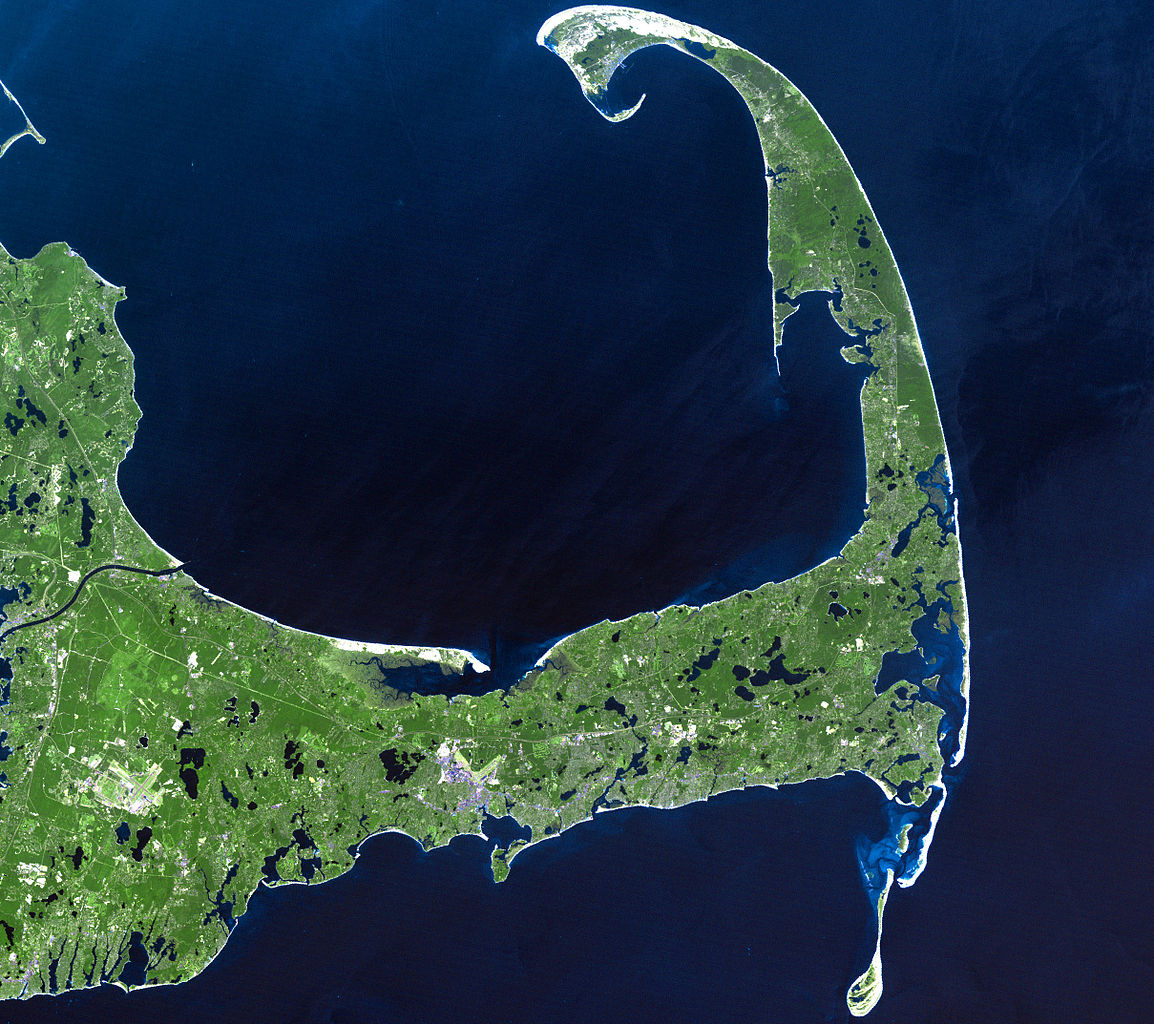
English: In easternmost Massachusetts, Cape Cod juts dramatically out into the Atlantic Ocean. The 65-mile peninsula has Cape Cod Bay to its north, the Nantucket Sound to its south and the Atlantic Ocean to its east. It is the world’s largest glacially formed peninsula; a remnant landscape left by the retreating Laurentide Ice Sheet.
The outer shore of the cape, from Long Point to south of Pleasant Bay, was designated as the Cape Cod National Seashore in August of 1961. The National Seashore encompasses over 44,000 acres of land, which includes marine, estuarine, and freshwater ecosystems. This Landsat 7 image was acquired on June 22, 2002. The pseudo-natural colour image, is a composite of ETM+ bands 7, 5, and 3. Cape Cod is found on Landsat WRS-2 Path 11 Row 31. |
| Tarih |
22 Haziran 2002 |
| Kaynak |
http://landsat.gsfc.nasa.gov/images/lg_jpg/f0006_06.22.02.jpg (http://landsat.gsfc.nasa.gov/images/archive/f0006.html) |
| Yazar |
NASA/Landsat 7. Original uploader was Ktr101 at en.wikipedia |
Lisanslama
| Bu dosya NASA tarafından üretildiği için kamu malıdır. Aksi belirtilmediği sürece "NASA tarafından üretilen malzemenin telif hakkı olmadığı" NASA telif politikasında belirtilmiştir. (Bkz. Template:PD-USGov, NASA copyright policy page veya JPL Image Use Policy.) | ||
 |
Uyarılar:
|
Cape Cod Landsat 7.jpg adlı görüntü kamu malıdır çünkü içeriği, ABD İç İşleri Bakanlığı (United States Department of Interior) bünyesindeki bir daire olan Birleşik Devletler Jeolojik Etüd (BDJE; United States Geological Survey, USGS) kökenli özgün malzeme ile ilgilidir.
Daha ayrıntılı bilgi için, bakın: BDJE'nin resmi telif hakkı uygulaması.
|
Orijinal yükleme günlüğü
Dosyanın orjinal açıklama sayfası burada bulunmaktadır. Aşağıdaki tüm kullanıcı adları için en.wikipedia bakın.
- 2008-06-14 02:08 Ktr101 2418×2145× (1120814 bytes) Cape Cod from a Landsat 7 image in 2002. Source:http://landsat.gsfc.nasa.gov/images/archive/f0006.html
Dosya geçmişi
Dosyanın herhangi bir zamandaki hâli için ilgili tarih/saat kısmına tıklayın.
| Tarih/Saat | Küçük resim | Boyutlar | Kullanıcı | Yorum | |
|---|---|---|---|---|---|
| güncel | 16.13, 9 Ağustos 2009 | | 2.418 × 2.145 (1,07 MB) | Transatracurium | {{Information |Description={{en| In easternmost Massachusetts, Cape Cod juts dramatically out into the Atlantic Ocean. The 65-mile peninsula has Cape Cod Bay to its north, the Nantucket Sound to its south and the Atlantic Ocean to its east. It is the worl |
Dosya kullanımı
Bu görüntü dosyasına bağlanan sayfa yok.
Küresel dosya kullanımı
Aşağıdaki diğer vikiler bu dosyayı kullanır:
- ca.wikipedia.org üzerinde kullanımı
- de.wikipedia.org üzerinde kullanımı
- en.wikipedia.org üzerinde kullanımı
- Cape Cod
- User:Dchurbuck
- User:Cape cod naturalist
- User:Clariosophic
- User:Seduisant
- User:Quissett
- Attack on Orleans
- User:Lrsears
- Wikipedia:WikiProject Cape Cod and the Islands
- Template:User WikiProject Cape Cod and the Islands
- User:Ktr101/Userboxes
- User:Grolltech
- User:Happyandrew1994
- Wikipedia:Userboxes/WikiProjects/Regional/03
- Shields (album)
- Wikipedia:Userboxes/WikiProjects/alphabetical/06
- Category:Wikipedians interested in Cape Cod and the Islands
- User:M V D H P
- he.wikipedia.org üzerinde kullanımı
- mk.wikipedia.org üzerinde kullanımı
- sk.wikipedia.org üzerinde kullanımı
- sr.wikipedia.org üzerinde kullanımı
- www.wikidata.org üzerinde kullanımı