Dosya:Basin of Lop Nur 90.25E, 40.10N, Desert of Lop, Kum Tagh and Astin Tagh.jpg

Bu önizlemenin boyutu: 800 × 520 piksel. Diğer çözünürlükler: 320 × 208 piksel | 640 × 416 piksel | 1.024 × 666 piksel | 1.280 × 832 piksel | 2.539 × 1.651 piksel.
Tam çözünürlük ((2.539 × 1.651 piksel, dosya boyutu: 2,5 MB, MIME tipi: image/jpeg))
Bu dosya Wikimedia Commons'ta bulunmaktadır. Dosyanın açıklaması aşağıda gösterilmiştir. Commons, serbest/özgür telifli medya dosyalarının bulundurulduğu depodur. Siz de yardım edebilirsiniz. |
Özet
| Açıklama |
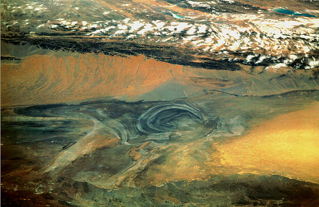
English: China, Xinjiang, desert Lop Nur. Satellite picture of the Basin of the formerly sea Lop Nur in the Desert of Lop. In the foreground Kuruktagh, in the background Kumtagh and Astintagh. A duststorm is blowing to the west over the Desert of Lop. Two lakes appear in a break in the clouds covering the Plateau of Astintagh. Visible are elongated Ayakkum Hu Lake south-southwest of Lop Nur and small blue-green Gas Hu Lake.
Deutsch: China, Xinjiang, Wüste Lop Nor. Satellitenaufnahme von dem mittleren Teil des Seebeckens Lop Nor und der Wüste Lop Nor, über die ein Sandsturm hinweggeht. Im Vordergrund sieht man die Hänge des Gebirges Kuruktagh, im Hintergrund die Hänge des Kumtagh und die Hochebene des Astintagh, auf der rechts der See Ayakkum Hu und links der kleinere See Gas Hu liegen. Blick von Norden Richtung Süden. |
| Tarih | |
| Kaynak | NASA Mission: STS047, Roll-Frame 151 – 26, File name STS047-151-26.JPG. [1]. See also: [2]. |
| Yazar |
English: NASA. Image courtesy of Earth Sciences and Image Analysis Laboratory, NASA Johnson Space Center. Color adjusting of this image (using Adobe Photoshop 6.0): Michael Gaebler, 02. March 2006, own work, all rights released (Public domain).
Deutsch: Zugrunde liegt ein noch nicht farbrichtiges Astronauten-Foto der NASA. Diese Fotografie wurde von Michael Gaebler am 02. März 2006 im RGB-Modus mit Adobe Photoshop 6.0 mit Farb- und Tonwertkorrekturen überarbeitet. |
| İzin (Bu dosyanın tekrar kullanımı) |
PD-USGov-NASA |
![[1]](ftp://eol.jsc.nasa.gov/EFS_highres_STS047_STS047-151-26.JPG)
Bu görüntü veya video ABD Ulusal Havacılık ve Uzay Dairesi (NASA) merkezlerinden birisitarafından Fotoğraf ID: STS047-151-26 ile kataloğa alınmıştır. Bu etiket, ekli çalışmanın telif hakkı durumunu göstermez. Normal bir telif hakkı etiketi hâlâ gereklidir. Commons:Lisanslama sayfasına bakın. Diğer diller:
|
Lisanslama
| Bu dosya NASA tarafından üretildiği için kamu malıdır. Aksi belirtilmediği sürece "NASA tarafından üretilen malzemenin telif hakkı olmadığı" NASA telif politikasında belirtilmiştir. (Bkz. Template:PD-USGov, NASA copyright policy page veya JPL Image Use Policy.) | ||
 |
Uyarılar:
|
Dosya geçmişi
Dosyanın herhangi bir zamandaki hâli için ilgili tarih/saat kısmına tıklayın.
| Tarih/Saat | Küçük resim | Boyutlar | Kullanıcı | Yorum | |
|---|---|---|---|---|---|
| güncel | 22.46, 10 Mart 2006 | | 2.539 × 1.651 (2,5 MB) | Michael Gäbler | {{Information| |Description = en: China, Xinjiang, desert Lop Nur. Satellite picture of the Basin of the formerly sea Lop Nur in the Desert of Lop. In the foreground Kuruktagh, in the background Kumtagh and Astintagh. A duststorm is blowing to th |
Dosya kullanımı
Bu görüntü dosyasına bağlantısı olan sayfalar:
Küresel dosya kullanımı
Aşağıdaki diğer vikiler bu dosyayı kullanır:
- az.wikipedia.org üzerinde kullanımı
- de.wikipedia.org üzerinde kullanımı
- en.wikipedia.org üzerinde kullanımı
- en.wikibooks.org üzerinde kullanımı
- es.wikipedia.org üzerinde kullanımı
- fa.wikipedia.org üzerinde kullanımı
- frr.wikipedia.org üzerinde kullanımı
- he.wikivoyage.org üzerinde kullanımı
- hi.wikipedia.org üzerinde kullanımı
- id.wikipedia.org üzerinde kullanımı
- it.wikipedia.org üzerinde kullanımı
- ja.wikipedia.org üzerinde kullanımı
- ka.wikipedia.org üzerinde kullanımı
- ko.wikipedia.org üzerinde kullanımı
- mn.wikipedia.org üzerinde kullanımı
- pa.wikipedia.org üzerinde kullanımı
- pl.wikipedia.org üzerinde kullanımı
- pnb.wikipedia.org üzerinde kullanımı
- ro.wikipedia.org üzerinde kullanımı
- sh.wikipedia.org üzerinde kullanımı
- sl.wikipedia.org üzerinde kullanımı
- sr.wikipedia.org üzerinde kullanımı
- sv.wikipedia.org üzerinde kullanımı
- te.wikipedia.org üzerinde kullanımı
- ug.wikipedia.org üzerinde kullanımı
- uk.wikipedia.org üzerinde kullanımı
- ur.wikipedia.org üzerinde kullanımı
- www.wikidata.org üzerinde kullanımı
- zh.wikipedia.org üzerinde kullanımı