Dosya:Balkan boundaries1876map1914.png

Tam çözünürlük ((984 × 712 piksel, dosya boyutu: 73 KB, MIME tipi: image/png))
Bu dosya Wikimedia Commons'ta bulunmaktadır. Dosyanın açıklaması aşağıda gösterilmiştir. Commons, serbest/özgür telifli medya dosyalarının bulundurulduğu depodur. Siz de yardım edebilirsiniz. |

|
This map has been uploaded by Electionworld from en.wikipedia.org to enable the |
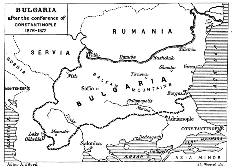
| Açıklama | Map from "Report of the International Commission To Inquire into the Causes and Conduct of the Balkan Wars" 1914. |
| Tarih | Map printed and published 1914 |
| Kaynak | a map |
| Yazar | Source: [1] - JPG to PNG by Iain 09:30, 13 June 2006 (UTC) |
| İzin (Bu dosyanın tekrar kullanımı) |
Original File PD |
| Diğer sürümler | Original Image Image:Balkan boundaries1876map1914.jpg now redundant |
|
Bu çalışma ABD'de veya yazarın yaşamının sona ermiş olmasından 70 veya daha fazla süre geçtiğinde bu duruma uygun telif yasaları olan tüm ülkelerde kamu malıdır.
| |
| Bu dosya ve ilgili diğer hakları da dahil olmak üzere telif hakkı kapsamında bilinen tüm kısıtlamalar, serbest lisans olarak belirlenmiştir. | |
Dosya geçmişi
Dosyanın herhangi bir zamandaki hâli için ilgili tarih/saat kısmına tıklayın.
| Tarih/Saat | Küçük resim | Boyutlar | Kullanıcı | Yorum | |
|---|---|---|---|---|---|
| güncel | 22.17, 20 Aralık 2006 | | 984 × 712 (73 KB) | Electionworld | {{ew|en|Iain}} {{Information| |Description = Map from "Report of the International Commission To Inquire into the Causes and Conduct of the Balkan Wars" 1914. |Date = Map printed and published 1914 |Author = Source: [http://www.lib.utexas.edu/maps/histori |
Dosya kullanımı
Bu görüntü dosyasına bağlantısı olan sayfalar:
Küresel dosya kullanımı
Aşağıdaki diğer vikiler bu dosyayı kullanır:
- ar.wikipedia.org üzerinde kullanımı
- bg.wikipedia.org üzerinde kullanımı
- bs.wikipedia.org üzerinde kullanımı
- ca.wikipedia.org üzerinde kullanımı
- de.wikipedia.org üzerinde kullanımı
- el.wikipedia.org üzerinde kullanımı
- en.wikipedia.org üzerinde kullanımı
- et.wikipedia.org üzerinde kullanımı
- fa.wikipedia.org üzerinde kullanımı
- fr.wikipedia.org üzerinde kullanımı
- hr.wikipedia.org üzerinde kullanımı
- hu.wikipedia.org üzerinde kullanımı
- it.wikipedia.org üzerinde kullanımı
- mk.wikipedia.org üzerinde kullanımı
- nl.wikipedia.org üzerinde kullanımı
- no.wikipedia.org üzerinde kullanımı
- pl.wikipedia.org üzerinde kullanımı
- pt.wikipedia.org üzerinde kullanımı
- ro.wikipedia.org üzerinde kullanımı
- simple.wikipedia.org üzerinde kullanımı
- sk.wikipedia.org üzerinde kullanımı
- sq.wikipedia.org üzerinde kullanımı
- sr.wikipedia.org üzerinde kullanımı
- uk.wikipedia.org üzerinde kullanımı
- www.wikidata.org üzerinde kullanımı