Dosya:2010 Chile earthquake epicenter.png
Daha yüksek çözünürlüğe sahip sürüm bulunmamaktadır.
2010_Chile_earthquake_epicenter.png ((269 × 589 piksel, dosya boyutu: 112 KB, MIME tipi: image/png))
Bu dosya Wikimedia Commons'ta bulunmaktadır. Dosyanın açıklaması aşağıda gösterilmiştir. Commons, serbest/özgür telifli medya dosyalarının bulundurulduğu depodur. Siz de yardım edebilirsiniz. |
| Açıklama |
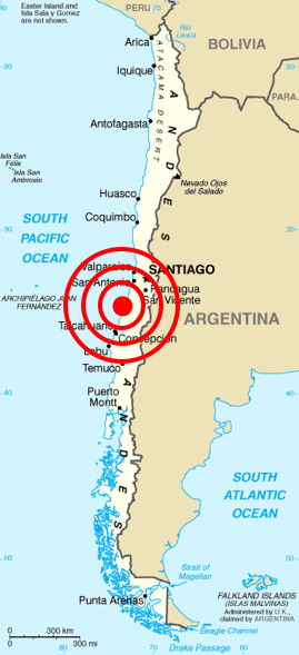
Deutsch: Karte von Chile aus dem CIA World Factbook mit dem Epizentrum des Erdbebens 2010 Chile
Español: Mapa de Chile de la CIA World Factbook, con el epicentro del terremoto de Chile 2010
Français : Carte du Chili de la CIA World Factbook avec l'épicentre du tremblement de terre du Chili 2010
Português: Mapa do Chile da CIA World Factbook, com o epicentro do terremoto do Chile em 2010 |
| Tarih | (original); 2010-02-27 (This image) |
| Kaynak | Originally from Central Intelligence Agency's World Factbook. Location of epicenter from BBC |
| Yazar | Central Intelligence Agency's World Factbook |
| İzin (Bu dosyanın tekrar kullanımı) |
PD-USGOV-CIA-WF. |
Lisanslama
ABD Merkezi İstihbarat Teşkilatı'nın World Factbook'tan gelen malzemeler içerdiğinden bu görüntü kamu malıdır.
|
 |
| Annotations | This image is annotated: View the annotations at Commons |
Dosya geçmişi
Dosyanın herhangi bir zamandaki hâli için ilgili tarih/saat kısmına tıklayın.
| Tarih/Saat | Küçük resim | Boyutlar | Kullanıcı | Yorum | |
|---|---|---|---|---|---|
| güncel | 13.45, 27 Şubat 2010 | | 269 × 589 (112 KB) | Cargoking | {{Information |Description=Map of en:Chile from [http://www.lib.utexas.edu/maps/cia02/chile_sm02.gif CIA World Factbook] with the epicenter of 2010 Chile earthquake marked. |Source=Originally from Central Intelligence Agen |
Dosya kullanımı
Bu görüntü dosyasına bağlantısı olan sayfalar:
Küresel dosya kullanımı
Aşağıdaki diğer vikiler bu dosyayı kullanır:
- be.wikipedia.org üzerinde kullanımı
- bg.wikipedia.org üzerinde kullanımı
- ckb.wikipedia.org üzerinde kullanımı
- cy.wikipedia.org üzerinde kullanımı
- da.wikipedia.org üzerinde kullanımı
- en.wikipedia.org üzerinde kullanımı
- en.wikinews.org üzerinde kullanımı
- eo.wikipedia.org üzerinde kullanımı
- es.wikinews.org üzerinde kullanımı
- et.wikipedia.org üzerinde kullanımı
- fa.wikipedia.org üzerinde kullanımı
- fi.wikipedia.org üzerinde kullanımı
- fr.wikinews.org üzerinde kullanımı
- ja.wikipedia.org üzerinde kullanımı
- ka.wikipedia.org üzerinde kullanımı
- lt.wikipedia.org üzerinde kullanımı
- ml.wikipedia.org üzerinde kullanımı
- ms.wikipedia.org üzerinde kullanımı
- no.wikinews.org üzerinde kullanımı
- pt.wikinews.org üzerinde kullanımı
- ro.wikipedia.org üzerinde kullanımı
- ro.wikinews.org üzerinde kullanımı
- ru.wikipedia.org üzerinde kullanımı
- ru.wikinews.org üzerinde kullanımı
- sh.wikipedia.org üzerinde kullanımı
- simple.wikipedia.org üzerinde kullanımı
- sq.wikipedia.org üzerinde kullanımı
- sr.wikipedia.org üzerinde kullanımı
- sv.wikipedia.org üzerinde kullanımı
- ta.wikinews.org üzerinde kullanımı
- th.wikipedia.org üzerinde kullanımı
- uk.wikinews.org üzerinde kullanımı
- vi.wikipedia.org üzerinde kullanımı
- www.wikidata.org üzerinde kullanımı
- zh.wikipedia.org üzerinde kullanımı