Dosya:Vinland Map HiRes.jpg

Tam çözünürlük ((3.038 × 2.103 piksel, dosya boyutu: 2,48 MB, MIME tipi: image/jpeg))
Bu dosya Wikimedia Commons'ta bulunmaktadır. Dosyanın açıklaması aşağıda gösterilmiştir. Commons, serbest/özgür telifli medya dosyalarının bulundurulduğu depodur. Siz de yardım edebilirsiniz. |

|
Bu bir seçkin resimdir. Vikipedi topluluğu tarafından güzel, şaşırtıcı, etkileyici ve/veya bilgilendirici bulunan bu resme seçkin resim statüsü verilmiş ve kullanıldığı maddeye önemli ölçüde katkı sağladığına karar verilmiştir. Eğer benzer kalitede özgür lisans etiketli bir resminiz varsa, yükleyebilir ve aday gösterebilirsiniz. |
| Bu resim 16 Kasım 2011 tarihinde Türkçe Vikipedi'de günün seçkin resmi olmuştur. |
| Bu resim 12 Ekim 2013 tarihinde Türkçe Vikipedi'de günün seçkin resmi olmuştur. |
| Bu resim 8 Mart 2015 tarihinde Türkçe Vikipedi'de günün seçkin resmi olmuştur. |
| Bu resim 19 Haziran 2017 tarihinde Türkçe Vikipedi'de günün seçkin resmi olmuştur. |
|

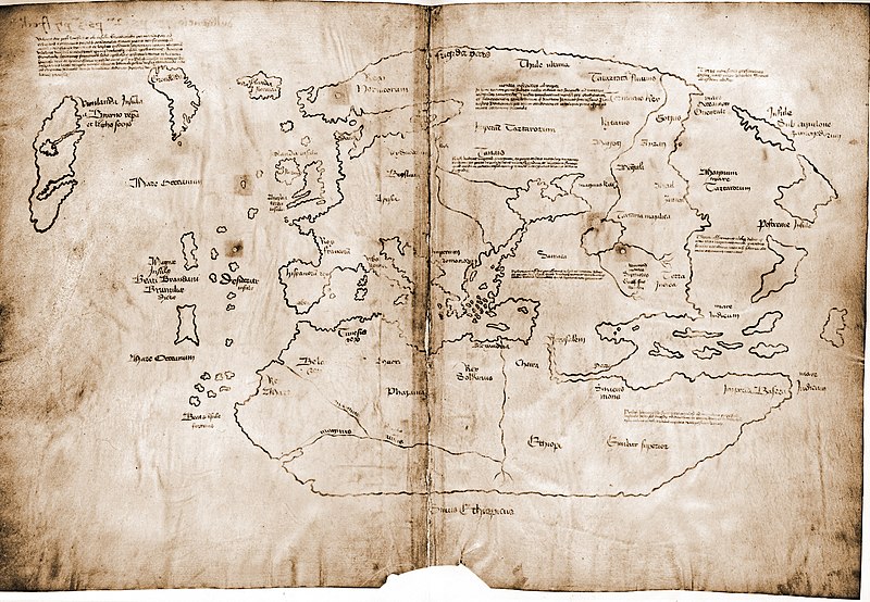
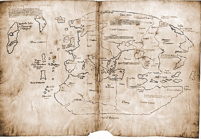
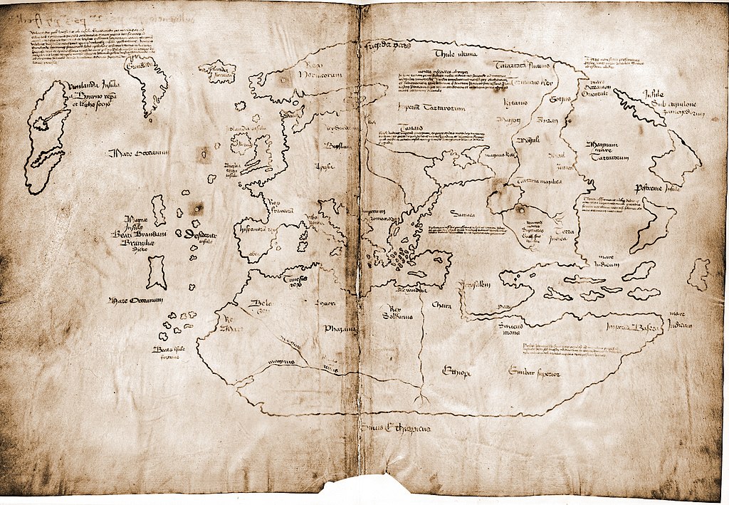
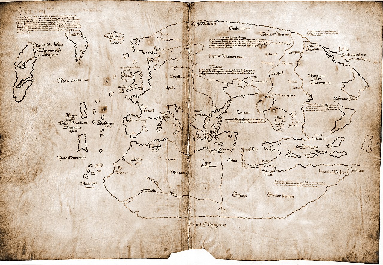
Bu görüntü 31 Aralık 2007 tarihinde günün resmi olarak seçilmiştir. Görüntünün başlığı o tarihte aşağıdaki gibiydi: English: The Vinland map, a 15th century world map purportedly based on a 13th century original. If authentic, it is the first known depiction of the North American coastline. Diğer diller:
Asturianu: Planisferiu del sieglu XV, copiáu d'un orixinal del sieglu XIII, cola primera referencia conocía de la costa Americana septentrional. Nél figura "Vinland" términu viquingu Bahasa Indonesia: Sebuah peta dunia buatan abad ke-15, dibuat ulang berdasarkan peta asli abad ke-13, peta pertama yang diketahui menggambarkan garis pantai Amerika Utara, di wilayah Vinland sekarang. Čeština: Mapa světa z 15. století jako přepis originálu ze 13. století, zachycující údajnou část amerického kontinentu Vinland objevenou možná již před Kolumbem vikingskými mořeplavci. Deutsch: Die Vinland-Karte aus dem 15. Jahrhundert ist die älteste bekannte Karte, die einen Küstenabschnitt Nordamerikas kartiert. Allerdings ist ihre Echtheit zweifelhaft. English: The Vinland map, a 15th century world map purportedly based on a 13th century original. If authentic, it is the first known depiction of the North American coastline. Español: Mapa de Vinlandia, un mapa del siglo XV supuestamente basado en un original del siglo XIII. De ser auténtico, se trataría de la primera representación conocida de la costa norteamericana. Français : Carte du monde au XVe siècle, redessinée à partir d'un original du XIIIe siècle ; première description connue de la côte de l'Amérique du Nord alors appelée Vinland. Italiano: Planisfero del XV secolo, tratto da un originale del XIII secolo, con la prima raffigurazione conosciuta delle coste dell'America settentrionale. Magyar: 15. századi világtérkép, egy 13. századi eredeti másolata, az észak-amerikai partvidék (akkori nevén Vinland) első ismert ábrázolása. Nederlands: 15e eeuwse wereldkaart, overgetekend van een 13e eeuws orgineel, met intekening van Vinland ("Wijnland") Polski: Gdyby była to XV-wieczna mapa świata, przerysowana z XIII-wiecznego oryginału, była by pierwszym znanym opisem wybrzeży Ameryki Północnej zwanej wówczas Vinland. Obecnie jednak jest uznawana za fałszerstwo Português: Um mapa-múndi do século XV, copiado de uma versão do século XIII, com um esboço da costa setentrional dos Estados Unidos. Svenska: Världskarta från 1400-talet, avbildad från ett original från 1300-talet. Det är den första kända avbildningen av Nordamerikas kust. Беларуская: Карта свету 15 ст., копія карты 13 ст. з першым вядомым паказам Вінланду — узбярэжжа Паўночнай Амерыкі. Русский: Карта мира XV века, перерисованная с оригинала XIII века и содержащая первое изображение побережья Северной Америки (обозначенное как Винланд). Српски / srpski: Мапа света из 15. века, прецртана од оригинала из 13. века који је прва позната скица северноамеричке обале, која се тада звала „Винленд“. 日本語: 15世紀の世界地図。当時ヴィンランドと呼ばれた北米の海岸線を、初めて描写したことで知られる13世紀の原画を描き直したもの。 中文: 15世纪时从13世纪原稿复制的世界地图,是首次描绘出北美洲海岸的地图,当时称北美洲为“葡萄地”。 |
Özet
| Açıklama |
Dimensions: 27.8 by 41.0 centimeters (10.9 by 16.1 inches) English: The Vinland map / chart is purportedly a 15th century Mappa Mundi, redrawn from a 13th century original. Drawn with black ink on animal skin, if authentic the map is the first known depiction of the North American coastline, created before Columbus' 1492 voyage. The upper left caption reads: “By God's will, after a long voyage from the island of Greenland to the south toward the most distant remaining parts of the western ocean sea, sailing southward amidst the ice, the companions Bjarni and Leif riksson discovered a new land, extremely fertile and even having vines, ... which island they named Vinland.” Most scholars and scientists who have studied the map have concluded that it is a fake, probably drawn on old parchment in the 20th century.
Deutsch: Die Vinland Mappe / Karte ist angeblich eine Weltkarte des 15. Jahrhunderts, neu gezeichnet von einem Original aus dem 13. Jahrhundert . Gezeichnet mit schwarzer Tinte auf Tierhaut, wenn sie echt wäre, wäre die Karte die erste bekannte Darstellung der nordamerikanischen Küste, die vor Kolumbus' Reise 1492. Im linken oberen Teil Inschrift: "Mit Gottes Willen, nach einer langen Reise von der Insel Grönland nach Süden durch das Eis segelnd zu den am weitesten entfernten übrigen Teilen des westlichen Ozeans, entdeckten die Gefährten Bjarni und Leif Erikssohn ein neues Land, äußerst fruchtbar und sogar mit Reben, eine Insel, die sie Vinland nannten" Die meisten Gelehrten und Wissenschaftler, die die Karte untersucht haben, kommen zu dem Schluss, dass die Karte eine Fälschung ist, die wahrscheinlich im 20. Jahrhundert auf alten Pergament gezeichnet wurde.
Français : La carte du Vinland est une carte datant peut-être du XVe siècle, et reprenant un original du XIIIe siècle. Tracée à l'encre noire sur du parchemin, cette carte est la première carte connue montrant la côte de L'Amérique du Nord, et est plus ancienne que le voyage de Christophe Colomb (1492). La légende en haut à gauche se lit “Par la volonté de Dieu et après un long voyage depuis l'île du Groenland vers les parts les plus lointaines de la mer océane de l'ouest, naviguant au sud au milieu des glaces, les compagnons Bjarni et Leif Eiriksson découvrirent une nouvelle terre, très fertile et portant de la vigne [...] ils la nommèrent Vinland.” La plupart des études au sujet de cette carte suggèrent qu'elle est truquée, dessinée au 20me siècle sur deux feuilles de parchemin anciennes.
Polski: Uznawana jako XV-wieczna mapa świata, przerysowana z XIII-wiecznego oryginału, gdyby była prawdziwa zawierała by pierwszy znany opis wybrzeży Ameryki Północnej zwanej wówczas Vinland. Obecnie jednak na podstawie analizy składu atramentu jest uznawana za fałszerstwo powstałe po 1923 roku.
Українська: Мапа Вінланду з атласу «Mappa mundi» XV століття, зроблена з оригіналу XIII століття. Зображення нанесені чорною фарбою на шкірі тварини. Автентична карта є першим відомим зображенням північноамериканського узбережжя, що було створене до подорожі Христофора Колумба 1492 року. У верхньому лівому кутку напис: «За Божою волею, після довгого плавання від острова Гренландія на південь до найдальших частин Західного океану моря, плавання на південь серед криги, товариші Б'ярні і Лейф Ерікссон віднайшли нову землю, дуже родючу й багату на виноград... землі названі Вінландом.»
Більшість дослідників і вчених, які вивчали карту, дійшли висновку, що це фальшивка, ймовірно, зроблена на старому пергаменті у XX столітті. |
| Tarih | |
| Kaynak | Yale University, from this website |
| Yazar | Yale University Press |
Lisanslama
If the map is real, then it is public domain by virtue of its age. In the far more likely possibility of it being fake, it is public domain because it was published without copyright notice before 1977 (even ignoring the question of if the true creator of the map forfeited copyright protection immediately by not openly claiming the work).
|
Bu görüntüde gösterilmekte olan iki boyutlu sanat yapıtı,
Dolayısıyla, o sanat yapıtına ait bu tekrar üretim görüntüsü de kamu malıdır.
Tanımlanan durum, ABD (bakınız, Bridgeman Art Library v. Corel Corp. - Bridgeman Sanat Kütüphanesi Corel Şirketine karşı), Almanya ve diğer pek çok ülkede yaratılmış tekrar üretimler için geçerlidir.
| ||||
This work is in the public domain in the United States because it was published in the United States between 1929 and 1977, inclusive, without a copyright notice. For further explanation, see Commons:Hirtle chart as well as a detailed definition of "publication" for public art. Note that it may still be copyrighted in jurisdictions that do not apply the rule of the shorter term for US works (depending on the date of the author's death), such as Canada (50 p.m.a.), Mainland China (50 p.m.a., not Hong Kong or Macao), Germany (70 p.m.a.), Mexico (100 p.m.a.), Switzerland (70 p.m.a.), and other countries with individual treaties.
|
 |
| Annotations | This image is annotated: View the annotations at Commons |
Dosya geçmişi
Dosyanın herhangi bir zamandaki hâli için ilgili tarih/saat kısmına tıklayın.
| Tarih/Saat | Küçük resim | Boyutlar | Kullanıcı | Yorum | |
|---|---|---|---|---|---|
| güncel | 21.15, 7 Eylül 2007 | | 3.038 × 2.103 (2,48 MB) | Jeff Dahl | {{Information |Description=The Vinland map is purportedly a 15th century Mappa Mundi, redrawn from a 13th century original. |Source=Yale University |Date=9-7-07 |Author= |Permission= |other_versions= }} |
Dosya kullanımı
Bu görüntü dosyasına bağlantısı olan sayfalar:
- Leif Ericson
- Vinland
- Vinland Haritası
- Vikipedi:Günün seçkin resmi/Ekim 2013
- Vikipedi:Günün seçkin resmi/Haziran 2017
- Vikipedi:Günün seçkin resmi/Kasım 2011
- Vikipedi:Günün seçkin resmi/Mart 2015
- Vikipedi:Seçkin resim adayları/Arşiv/Ocak 2010
- Vikipedi:Seçkin resim adayları/Vinland Map HiRes.jpg
- Vikipedi:Seçkin resimler/Ana sayfaya çıkmış resimler/2011 listesi
- Vikipedi:Seçkin resimler/Ana sayfaya çıkmış resimler/2013 listesi
- Vikipedi:Seçkin resimler/Ana sayfaya çıkmış resimler/2015 listesi
- Vikipedi:Seçkin resimler/Çizimler, diyagramlar ve haritalar/Haritalar
- Vikipedi:Wikimedia Commons
- Şablon:GSR/2011-11-16
- Şablon:GSR/2013-10-12
- Şablon:GSR/2015-03-08
- Şablon:GSR/2017-06-19
Küresel dosya kullanımı
Aşağıdaki diğer vikiler bu dosyayı kullanır:
- af.wikipedia.org üzerinde kullanımı
- ar.wikipedia.org üzerinde kullanımı
- az.wikipedia.org üzerinde kullanımı
- ba.wikipedia.org üzerinde kullanımı
- be.wikipedia.org üzerinde kullanımı
- bg.wikipedia.org üzerinde kullanımı
- bn.wikipedia.org üzerinde kullanımı
- ca.wikipedia.org üzerinde kullanımı
- cs.wikipedia.org üzerinde kullanımı
- cv.wikipedia.org üzerinde kullanımı
- da.wikipedia.org üzerinde kullanımı
- de.wikipedia.org üzerinde kullanımı
- en.wikipedia.org üzerinde kullanımı
- Vinland Map
- Norse colonization of North America
- October 1965
- Portal:Norway/Selected picture
- Portal:Maps/Selected picture
- Wikipedia:Featured pictures thumbs/08
- Wikipedia:Featured picture candidates/October-2007
- Wikipedia:Featured picture candidates/Vinland Map
- Wikipedia:Wikipedia Signpost/2007-10-22/Features and admins
- Portal:Maps/Selected picture/28
- User talk:Jeff Dahl/Archive 1
- Portal:Geography/Featured picture/2008, week 1
- Wikipedia:Picture of the day/February 2008
- Template:POTD/2008-02-26
- Portal:Norway/Selected picture/21
- User talk:Jeff Dahl/Archive 3
- Wikipedia:Featured pictures/Diagrams, drawings, and maps/Maps
- Wikipedia:WikiProject Arctic
- Wikipedia:Wikipedia Signpost/2007-10-22/SPV
- Portal:Geography/Featured picture archive/2008
- Exploration of North America
- Talk:Norton Internet Security/Archive 1
- User:ArjunChikkappa/Norse colonization of North America
- Wikipedia:Wikipedia Signpost/Single/2007-10-22
Bu dosyanın daha fazla küresel kullanımını görüntüle.