Dosya:MapOfTutuila-American-Samoa.png

Bu önizlemenin boyutu: 800 × 519 piksel. Diğer çözünürlükler: 320 × 208 piksel | 640 × 415 piksel | 1.024 × 664 piksel | 1.280 × 831 piksel | 3.033 × 1.968 piksel.
Tam çözünürlük ((3.033 × 1.968 piksel, dosya boyutu: 338 KB, MIME tipi: image/png))
Bu dosya Wikimedia Commons'ta bulunmaktadır. Dosyanın açıklaması aşağıda gösterilmiştir. Commons, serbest/özgür telifli medya dosyalarının bulundurulduğu depodur. Siz de yardım edebilirsiniz. |
Özet
| Açıklama |
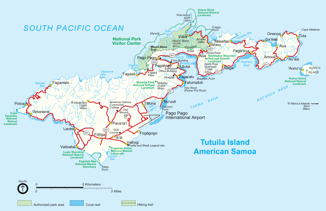
English: NPS map of Tutuila, American Samoa |
| Tarih | circa 2002 |
| Kaynak | http://www.nps.gov/archive/npsa/pdf/tutuila.pdf, modified and converted into .png |
| Yazar | NPS, modified by Durin, converted by Telim tor |
| Diğer sürümler | Original .gif version |
Lisanslama
| This image or media file contains material based on a work of a National Park Service employee, created as part of that person's official duties. As a work of the U.S. federal government, such work is in the public domain in the United States. See the NPS website and NPS copyright policy for more information. |
| This work was previously under Public Domain, or a Free License. It has been digitally enhanced and/or modified. This derivative work has been (or is hereby) released into the public domain by its author, Telim tor at the German Wikipedia project. This applies worldwide. In some countries this is not legally possible; if so:
|
Dosya geçmişi
Dosyanın herhangi bir zamandaki hâli için ilgili tarih/saat kısmına tıklayın.
| Tarih/Saat | Küçük resim | Boyutlar | Kullanıcı | Yorum | |
|---|---|---|---|---|---|
| güncel | 10.08, 3 Ekim 2009 | | 3.033 × 1.968 (338 KB) | Telim tor | == {{int:filedesc}} == {{Information |Description={{en|NPS map of Tutuila, Anerican Samoa}} |Source=http://www.nps.gov/archive/npsa/pdf/tutuila.pdf, modified and converted into .png |Date=ca. 2002 |Author=NPS, modified by Durin, converted |
Dosya kullanımı
Bu görüntü dosyasına bağlantısı olan sayfalar:
Küresel dosya kullanımı
Aşağıdaki diğer vikiler bu dosyayı kullanır:
- az.wikipedia.org üzerinde kullanımı
- cy.wikipedia.org üzerinde kullanımı
- de.wikipedia.org üzerinde kullanımı
- pl.wikipedia.org üzerinde kullanımı