Dosya:Karte - Kesselschlachte bei Vjazma und Brjansk 1941.png
Bu önizlemenin boyutu: 441 × 599 piksel. Diğer çözünürlükler: 177 × 240 piksel | 353 × 480 piksel | 566 × 768 piksel | 754 × 1.024 piksel | 2.002 × 2.718 piksel.
Tam çözünürlük ((2.002 × 2.718 piksel, dosya boyutu: 1,56 MB, MIME tipi: image/png))
Bu dosya Wikimedia Commons'ta bulunmaktadır. Dosyanın açıklaması aşağıda gösterilmiştir. Commons, serbest/özgür telifli medya dosyalarının bulundurulduğu depodur. Siz de yardım edebilirsiniz. |
Özet
| Açıklama |
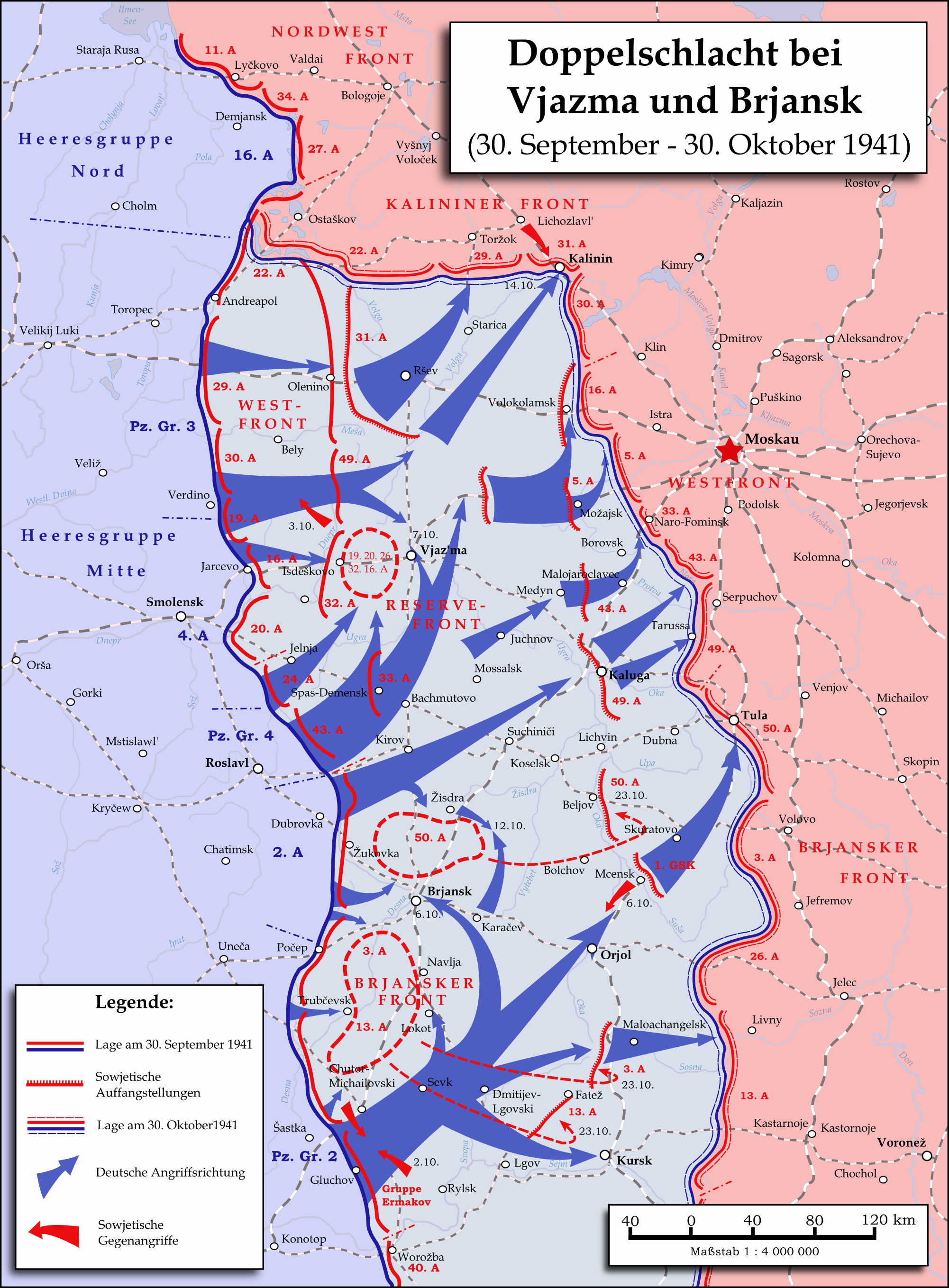
English: Map showing the two battles near Vyazma (October 2nd — October 20th 1941) and Brjansk (September 30th - October, 23rd) during the Second World War (1939—1945) at the Eastern Front. The map was created in Inkscape and is based on Map 30 in the attachment of the book P.N. Pospelow (Hrsg.): Geschichte des Großen Vaterländischen Krieges der Sowjetunion, Bd. 2, Berlin (Ost) 1963. The troop movements have been corrected.
Deutsch: Karte der Doppelschlacht im Raum Vjasma und Brjansk (30. September — 23. Oktober 1941) während des Zweiten Weltkrieges (1939—1945) an der Ostfront. Die Karte wurde mit Inkscape erstellt und basiert auf Karte Nr. 30 aus dem Anhang des Buches P.N. Pospelow (Hrsg.): Geschichte des Großen Vaterländischen Krieges der Sowjetunion, Bd. 2, Berlin (Ost) 1963. Die Truppenbewegungen wurden jedoch korrigiert. |
| Tarih | |
| Kaynak | Yükleyenin kendi çalışması |
| Yazar | Memnon335bc |
Lisanslama
Ben, bu işin telif sahibi, burada işi aşağıdaki lisans altında yayımlıyorum:
Bu dosya, Creative Commons Atıf 3.0 Uluslararası lisansı ile lisanslanmıştır
- Şu seçeneklerde özgürsünüz:
- paylaşım – eser paylaşımı, dağıtımı ve iletimi
- içeriği değiştirip uyarlama – eser adaptasyonu
- Aşağıdaki koşullar geçerli olacaktır:
- atıf – Esere yazar veya lisans sahibi tarafından belirtilen (ancak sizi ya da eseri kullanımınızı desteklediklerini ileri sürmeyecek bir) şekilde atıfta bulunmalısınız.
Dosya geçmişi
Dosyanın herhangi bir zamandaki hâli için ilgili tarih/saat kısmına tıklayın.
| Tarih/Saat | Küçük resim | Boyutlar | Kullanıcı | Yorum | |
|---|---|---|---|---|---|
| güncel | 22.06, 31 Mayıs 2015 | | 2.002 × 2.718 (1,56 MB) | Cmdrjameson | Compressed with pngout. Reduced by 600kB (27% decrease). |
| 12.01, 18 Eylül 2009 |  | 2.002 × 2.718 (2,15 MB) | Memnon335bc | {{Information |Description={{en|1=Map showing the Twin-Battlea near Vyazma (October 2nd — October 20th 1941) and Brjansk (September 30th - Octpber, 23rd) during the Second World War (1939—1945) at the Eastern Front. The map is created by Inkscape and |
Dosya kullanımı
Bu görüntü dosyasına bağlantısı olan sayfalar:
Küresel dosya kullanımı
Aşağıdaki diğer vikiler bu dosyayı kullanır:
- azb.wikipedia.org üzerinde kullanımı
- az.wikipedia.org üzerinde kullanımı
- ba.wikipedia.org üzerinde kullanımı
- be.wikipedia.org üzerinde kullanımı
- de.wikipedia.org üzerinde kullanımı
- en.wikipedia.org üzerinde kullanımı
- es.wikipedia.org üzerinde kullanımı
- et.wikipedia.org üzerinde kullanımı
- fr.wikipedia.org üzerinde kullanımı
- it.wikipedia.org üzerinde kullanımı
- ja.wikipedia.org üzerinde kullanımı
- nl.wikipedia.org üzerinde kullanımı
- pl.wikipedia.org üzerinde kullanımı
- pt.wikipedia.org üzerinde kullanımı
- ru.wikipedia.org üzerinde kullanımı
- sl.wikipedia.org üzerinde kullanımı
- th.wikipedia.org üzerinde kullanımı
- tt.wikipedia.org üzerinde kullanımı
- vi.wikipedia.org üzerinde kullanımı
- zh.wikipedia.org üzerinde kullanımı