Dosya:Kabardino-balkaria map.png
Daha yüksek çözünürlüğe sahip sürüm bulunmamaktadır.
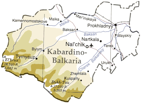
Kabardino-balkaria_map.png ((450 × 329 piksel, dosya boyutu: 33 KB, MIME tipi: image/png))
Bu dosya Wikimedia Commons'ta bulunmaktadır. Dosyanın açıklaması aşağıda gösterilmiştir. Commons, serbest/özgür telifli medya dosyalarının bulundurulduğu depodur. Siz de yardım edebilirsiniz. |
| Açıklama |
Map of en:Kabardino-Balkaria, en:Russia en:Category:Caucasus maps en:Category:Maps of the Russian republics |
|||
| Kaynak | Adapted from "The Caucasus Region" map, US Dept of State [1] | |||
| Yazar | User ChrisO on en.wikipedia (uploaded to commons by User:StYxXx) | |||
| İzin (Bu dosyanın tekrar kullanımı) |
|
|||
| Diğer sürümler |
Bu dosyanın türev çalışmaları: Originally from en.wikipedia; description page is (was) here {{Information |Description=The cooling towers of [[Stella power station]]. |Source=Scanned black and white print |Date=1990 |Author=Aidan Doyle }}{{Information |Description=The cooling towers of [[Stella power station]]. |Source=Scanned black and white print |Date=1990 |Author=Aidan Doyle }}••••••••••••••• |

![[1]](http://www.lib.utexas.edu/maps/commonwealth/caucasus_region_1994.jpg)
(Uploaded using CommonsHelper or PushForCommons)
Dosya geçmişi
Dosyanın herhangi bir zamandaki hâli için ilgili tarih/saat kısmına tıklayın.
| Tarih/Saat | Küçük resim | Boyutlar | Kullanıcı | Yorum | |
|---|---|---|---|---|---|
| güncel | 19.45, 12 Kasım 2006 | | 450 × 329 (33 KB) | StYxXx | {{Information| |Description= Map of en:Kabardino-Balkaria, en:Russia Adapted from "The Caucasus Region" map, US Dept of State [http://www.lib.utexas.edu/maps/commonwealth/caucasus_region_1994.jpg] en:Category:Caucasus maps [[:en:Category: |
Dosya kullanımı
Bu görüntü dosyasına bağlantısı olan sayfalar:
Küresel dosya kullanımı
Aşağıdaki diğer vikiler bu dosyayı kullanır:
- ar.wikipedia.org üzerinde kullanımı
- ast.wikipedia.org üzerinde kullanımı
- ceb.wikipedia.org üzerinde kullanımı
- cy.wikipedia.org üzerinde kullanımı
- da.wikipedia.org üzerinde kullanımı
- de.wikipedia.org üzerinde kullanımı
- el.wikipedia.org üzerinde kullanımı
- en.wikipedia.org üzerinde kullanımı
- eo.wikipedia.org üzerinde kullanımı
- es.wikipedia.org üzerinde kullanımı
- eu.wikipedia.org üzerinde kullanımı
- fa.wikipedia.org üzerinde kullanımı
- fi.wikipedia.org üzerinde kullanımı
- fr.wikipedia.org üzerinde kullanımı
- gag.wikipedia.org üzerinde kullanımı
- hu.wikipedia.org üzerinde kullanımı
- ko.wikipedia.org üzerinde kullanımı
- nl.wikipedia.org üzerinde kullanımı
- nn.wikipedia.org üzerinde kullanımı
- pl.wikipedia.org üzerinde kullanımı
- sah.wikipedia.org üzerinde kullanımı
- sr.wikipedia.org üzerinde kullanımı
- uk.wikipedia.org üzerinde kullanımı
- www.wikidata.org üzerinde kullanımı