Dosya:Istanbul PU889.jpg

Tam çözünürlük ((7.284 × 5.043 piksel, dosya boyutu: 6,23 MB, MIME tipi: image/jpeg))
Bu dosya Wikimedia Commons'ta bulunmaktadır. Dosyanın açıklaması aşağıda gösterilmiştir. Commons, serbest/özgür telifli medya dosyalarının bulundurulduğu depodur. Siz de yardım edebilirsiniz. |

|
Bu bir seçkin resimdir. Vikipedi topluluğu tarafından güzel, şaşırtıcı, etkileyici ve/veya bilgilendirici bulunan bu resme seçkin resim statüsü verilmiş ve kullanıldığı maddeye önemli ölçüde katkı sağladığına karar verilmiştir. Eğer benzer kalitede özgür lisans etiketli bir resminiz varsa, yükleyebilir ve aday gösterebilirsiniz. |
| Bu resim 29 Aralık 2011 tarihinde Türkçe Vikipedi'de günün seçkin resmi olmuştur. |
| Bu resim 14 Mayıs 2019 tarihinde Türkçe Vikipedi'de günün seçkin resmi olmuştur. |
Özet
|
| Açıklama |
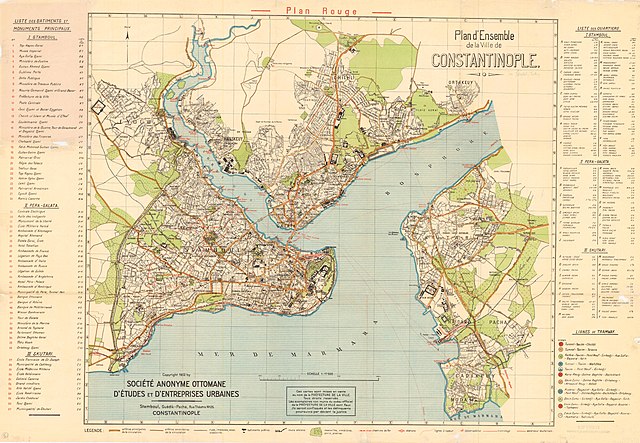
Istanbul city map Title: Plan d'ensemble de la ville de Constantinople. Publisher: Societe anonyme ottomane d'etudes et d'enterprises urbaines PubInfo: 1922 Description: This map was scanned with a Chroma Tx 40 Plus Wide Format color scanner and WIDEimage 2.8 software at 400 DPI in 24-bit color. The image was then reduced to 256 colors and saved in a TIFF file format. Later the TIFF image was compressed by the Mapping Sci |
| Tarih | |
| Kaynak | Princeton Library http://gisserver.princeton.edu:81/navigatorMapViewer.htm?map=889 |
| Yazar | Societe anonyme ottomane d'etudes et d'enterprises urbaines |
Lisanslama
|
Bu çalışma ABD'de veya yazarın yaşamının sona ermiş olmasından 70 veya daha fazla süre geçtiğinde bu duruma uygun telif yasaları olan tüm ülkelerde kamu malıdır.
| |
| Bu dosya ve ilgili diğer hakları da dahil olmak üzere telif hakkı kapsamında bilinen tüm kısıtlamalar, serbest lisans olarak belirlenmiştir. | |
Summary (original)
Plan d'Istanbul par la Société Anonyme Ottomane d'Etudes et d'Enterprises Urbaines, 1922
Dosya geçmişi
Dosyanın herhangi bir zamandaki hâli için ilgili tarih/saat kısmına tıklayın.
| Tarih/Saat | Küçük resim | Boyutlar | Kullanıcı | Yorum | |
|---|---|---|---|---|---|
| güncel | 12.31, 26 Ocak 2013 | | 7.284 × 5.043 (6,23 MB) | Slick-o-bot | Bot: convert to a non-interlaced jpeg (see bug #17645) |
| 11.59, 10 Aralık 2005 |  | 7.284 × 5.043 (5,88 MB) | Neuceu | Plan d'Istanbul par la Société Anonyme Ottomane d'Etudes et d'Enterprises Urbaines, 1922 Source : http://gisserver.princeton.edu/metadataexplorer/search_results.jsp?goTo=search&north=41.718465&south=40.625131&east=29.386666&west=28&mode=ME&loggedIn=fal |
Dosya kullanımı
Bu görüntü dosyasına bağlantısı olan sayfalar:
- İstanbul'un ilçeleri
- İstanbul (il)
- İstanbul tarihi
- Kullanıcı mesaj:Seksen iki yüz kırk beş/Arşiv 1
- Vikipedi:Günün seçkin resmi/Aralık 2011
- Vikipedi:Günün seçkin resmi/Mayıs 2019
- Vikipedi:Günün seçkin resmi/Şubat 2024
- Vikipedi:Seçkin resim adayları/Arşiv/Nisan 2010
- Vikipedi:Seçkin resim adayları/Istanbul PU889.jpg
- Vikipedi:Seçkin resimler
- Vikipedi:Seçkin resimler/Ana sayfaya çıkmış resimler/2011 listesi
- Vikipedi:Seçkin resimler/Çizimler, diyagramlar ve haritalar/Haritalar
- Şablon:GSR/2011-12-29
- Şablon:GSR/2019-05-14
- Şablon:GSR/2024-02-08
Küresel dosya kullanımı
Aşağıdaki diğer vikiler bu dosyayı kullanır:
- af.wikipedia.org üzerinde kullanımı
- ckb.wikipedia.org üzerinde kullanımı
- fr.wikipedia.org üzerinde kullanımı
- fy.wikipedia.org üzerinde kullanımı
- he.wikipedia.org üzerinde kullanımı
- mk.wikipedia.org üzerinde kullanımı
- pcd.wikipedia.org üzerinde kullanımı
- tk.wikipedia.org üzerinde kullanımı