Dosya:Hawaje-NoRedLine.jpg

Tam çözünürlük ((3.600 × 2.800 piksel, dosya boyutu: 2,81 MB, MIME tipi: image/jpeg))
Bu dosya Wikimedia Commons'ta bulunmaktadır. Dosyanın açıklaması aşağıda gösterilmiştir. Commons, serbest/özgür telifli medya dosyalarının bulundurulduğu depodur. Siz de yardım edebilirsiniz. |
Özet
| Açıklama |
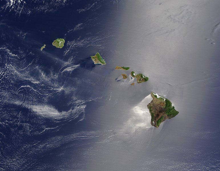
Čeština: Satelitní pohled na Havajské ostrovy
English: Satellite view of Hawaii archipelago (USA) Original description from NASA:
Français : Vue satellite de l'archipel d'Hawaï (États-Unis) |
| Tarih | |
| Kaynak |
|
| Yazar | Jacques Descloitres |
| Diğer sürümler |
 |
| Bu rötuşlanmış bir resim olup, resmin özgün hâli üzerinde oynama yapılarak elde edilmiştir. Yapılan değişiklikler: cloned out and healed little red line on the big island.Resmin özgün hâline şuradan erişilebilir: Hawaje.jpg. Resimdeki düzenlemeler IdLoveOne tarafından yapılmıştır.
|
Lisanslama
| Bu dosya NASA tarafından üretildiği için kamu malıdır. Aksi belirtilmediği sürece "NASA tarafından üretilen malzemenin telif hakkı olmadığı" NASA telif politikasında belirtilmiştir. (Bkz. Template:PD-USGov, NASA copyright policy page veya JPL Image Use Policy.) | ||
 |
Uyarılar:
|
Orijinal yükleme günlüğü
Bu dosya şu kaynaktan türetilmiştir: Hawaje.jpg
- File:Hawaje.jpg licensed with PD-USGov-NASA
- 2005-10-26T18:19:43Z Palladinus 3600x2800 (1211908 Bytes) Hawaii Islands
Uploaded with derivativeFX
Değerlendirme
|
Bu görüntü 16 Haziran 2011 tarihinde günün resmi olarak seçilmiştir. Görüntünün başlığı o tarihte aşağıdaki gibiydi: Diğer diller:
Čeština: Satelitní pohled na Havajské ostrovy Eesti: Hawaii saared satelliidifotol. Magyar: Hawaii szigetvilágának műholdas képe Português: Texto de cabeçalho. Русский: Спутниковая фотография Гавайских островов 한국어: 하와이 제도의 위성 사진. 日本語: ハワイ諸島の衛星写真 中文: 美国夏威夷的卫星照片 |
Dosya geçmişi
Dosyanın herhangi bir zamandaki hâli için ilgili tarih/saat kısmına tıklayın.
| Tarih/Saat | Küçük resim | Boyutlar | Kullanıcı | Yorum | |
|---|---|---|---|---|---|
| güncel | 22.24, 1 Eylül 2010 | | 3.600 × 2.800 (2,81 MB) | IdLoveOne~commonswiki | {{RetouchedPicture|cloned out and healed little red line on the big island|editor=IdLoveOne|orig=Hawaje.jpg}} {{self|PD-USGov-NASA}} == {{Original upload log}} == This image is a derivative work of the following images: *File:Hawaje.jpg licensed w |
Dosya kullanımı
Bu görüntü dosyasına bağlantısı olan sayfalar:
Küresel dosya kullanımı
Aşağıdaki diğer vikiler bu dosyayı kullanır:
- ace.wikipedia.org üzerinde kullanımı
- af.wikipedia.org üzerinde kullanımı
- als.wikipedia.org üzerinde kullanımı
- ar.wikipedia.org üzerinde kullanımı
- ary.wikipedia.org üzerinde kullanımı
- arz.wikipedia.org üzerinde kullanımı
- ast.wikipedia.org üzerinde kullanımı
- azb.wikipedia.org üzerinde kullanımı
- az.wikipedia.org üzerinde kullanımı
- ba.wikipedia.org üzerinde kullanımı
- be-tarask.wikipedia.org üzerinde kullanımı
- be.wikipedia.org üzerinde kullanımı
- bh.wikipedia.org üzerinde kullanımı
- bn.wikipedia.org üzerinde kullanımı
- bn.wikibooks.org üzerinde kullanımı
- ca.wikipedia.org üzerinde kullanımı
- ceb.wikipedia.org üzerinde kullanımı
- crh.wikipedia.org üzerinde kullanımı
- cs.wikipedia.org üzerinde kullanımı
- cv.wikipedia.org üzerinde kullanımı
- cy.wikipedia.org üzerinde kullanımı
- dag.wikipedia.org üzerinde kullanımı
- de.wikipedia.org üzerinde kullanımı
- diq.wikipedia.org üzerinde kullanımı
- el.wikipedia.org üzerinde kullanımı
- en.wikipedia.org üzerinde kullanımı
Bu dosyanın daha fazla küresel kullanımını görüntüle.