Dosya:Harz - Deutsche Mittelgebirge, Serie A-de.png
Tam çözünürlük ((2.450 × 1.300 piksel, dosya boyutu: 4,46 MB, MIME tipi: image/png))
Bu dosya Wikimedia Commons'ta bulunmaktadır. Dosyanın açıklaması aşağıda gösterilmiştir. Commons, serbest/özgür telifli medya dosyalarının bulundurulduğu depodur. Siz de yardım edebilirsiniz. |
Özet
| Açıklama |
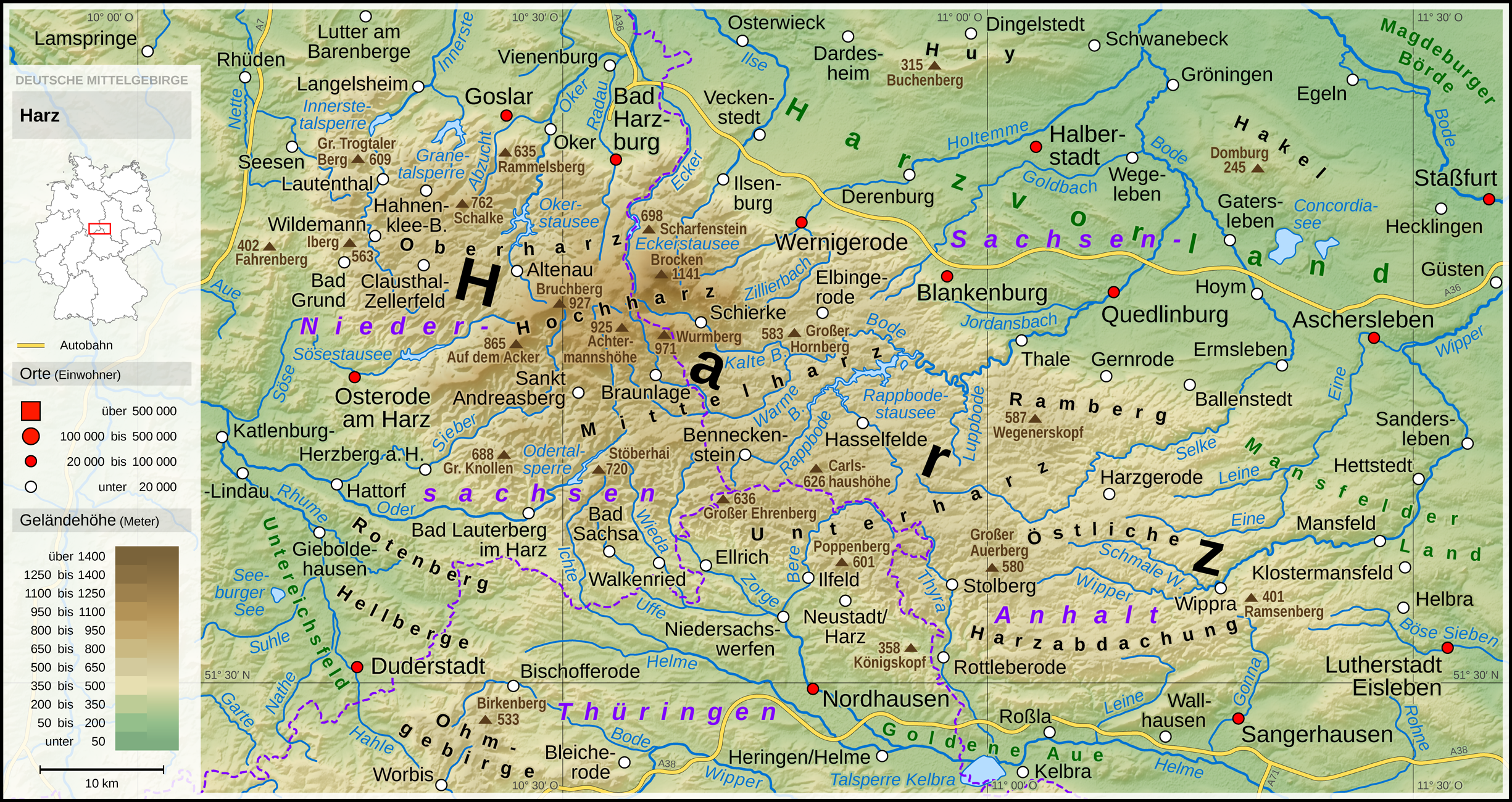
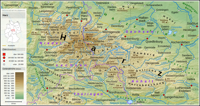
English: Topographic map of Harz
Deutsch: Topografische Karte des Harzes |
||||||||||||||||||
| Tarih | |||||||||||||||||||
| Kaynak |
Own work using: |
||||||||||||||||||
| Yazar | Thoroe | ||||||||||||||||||
| Diğer sürümler |
 Topographic maps of German low mountain ranges (A series)
This map series aims to show the major low mountain ranges of Germany in a uniform design. All maps are created on the same scale, and the background reliefs base upon the same color scheme. The reliefs are also available as separate files. You can find the making-of one of the maps in the German language Wikipedia (German only).
|
||||||||||||||||||


_-_Deutsche_Mittelgebirge,_Serie_A-de.png)
_-_Deutsche_Mittelgebirge,_Serie_A-de.png)
_-_Deutsche_Mittelgebirge,_Serie_A-de.png)
_-_Deutsche_Mittelgebirge,_Serie_A-de.png)
_-_Deutsche_Mittelgebirge,_Serie_A-de.png)
_-_Deutsche_Mittelgebirge,_Serie_A-de.png)
_-_Deutsche_Mittelgebirge,_Serie_A-de.png)
_-_Deutsche_Mittelgebirge,_Serie_A-de.png)
_-_Deutsche_Mittelgebirge,_Serie_A-de.png)
_-_Deutsche_Mittelgebirge,_Serie_A-de.png)
_-_Deutsche_Mittelgebirge,_Serie_A-de.png)
_-_Deutsche_Mittelgebirge,_Serie_A-de.png)
_-_Deutsche_Mittelgebirge,_Serie_A-de.png)
_-_Deutsche_Mittelgebirge,_Serie_A-de.png)
_-_Deutsche_Mittelgebirge,_Serie_A-de.png)
_-_Deutsche_Mittelgebirge,_Serie_A-de.png)
_-_Deutsche_Mittelgebirge,_Serie_A-de.png)
_-_Deutsche_Mittelgebirge,_Serie_A-de.png)
_-_Deutsche_Mittelgebirge,_Serie_A-de.png)
_-_Deutsche_Mittelgebirge,_Serie_A-de.png)
_-_Deutsche_Mittelgebirge,_Serie_A-de.png)
_-_Deutsche_Mittelgebirge,_Serie_A-de.png)
_-_Deutsche_Mittelgebirge,_Serie_A-de.png)
_-_Deutsche_Mittelgebirge,_Serie_A-de.png)
_-_Deutsche_Mittelgebirge,_Serie_A-de.png)
_-_Deutsche_Mittelgebirge,_Serie_A-de.png)
_-_Deutsche_Mittelgebirge,_Serie_A-de.png)
_-_Deutsche_Mittelgebirge,_Serie_A-de.png)
_-_Deutsche_Mittelgebirge,_Serie_A-de.png)
_-_Deutsche_Mittelgebirge,_Serie_A-de.png)
_-_Deutsche_Mittelgebirge,_Serie_A-de.png)
_-_Deutsche_Mittelgebirge,_Serie_A-de.png)
This work contains information from OpenStreetMap, which is made available under the Open Database License (ODbL). The ODbL does not require any particular license for maps produced from ODbL data. Prior to 1 August 2020, map tiles produced by the OpenStreetMap Foundation were licensed under the CC-BY-SA-2.0 license. Maps produced by other people may be subject to other licences. |

|
This map has been made or improved in the German Kartenwerkstatt (Map Lab). You can propose maps to improve as well.
|
Lisanslama
- Şu seçeneklerde özgürsünüz:
- paylaşım – eser paylaşımı, dağıtımı ve iletimi
- içeriği değiştirip uyarlama – eser adaptasyonu
- Aşağıdaki koşullar geçerli olacaktır:
- atıf – Esere yazar veya lisans sahibi tarafından belirtilen (ancak sizi ya da eseri kullanımınızı desteklediklerini ileri sürmeyecek bir) şekilde atıfta bulunmalısınız.
- benzer paylaşım – Maddeyi yeniden karıştırır, dönüştürür veya inşa ederseniz, katkılarınızı orijinal olarak aynı veya uyumlu lisans altında dağıtmanız gerekir.
Dosya geçmişi
Dosyanın herhangi bir zamandaki hâli için ilgili tarih/saat kısmına tıklayın.
| Tarih/Saat | Küçük resim | Boyutlar | Kullanıcı | Yorum | |
|---|---|---|---|---|---|
| güncel | 23.44, 31 Ocak 2019 | | 2.450 × 1.300 (4,46 MB) | Thoroe | Autobahn 36 / Autobahn 369 |
| 10.41, 19 Ekim 2017 |  | 2.450 × 1.300 (4,59 MB) | Thoroe | +Schierke, +Wippra, +Wallhausen, +Dardesheim, +Wegeleben, +Güsten, +Rammelsberg; and some other details | |
| 13.21, 16 Ekim 2017 |  | 2.450 × 1.300 (4,59 MB) | Thoroe | -Schulenberg +Hahnenklee Wiegersdorf->Ilfeld +Neustadt/Harz +Poppenberg | |
| 16.03, 15 Ekim 2017 |  | 2.450 × 1.300 (4,59 MB) | Thoroe | {{Information |Description ={{en|1=Topographic map of Harz}} {{de|1=Topografische Karte des Harzes}} |Source ={{Own using}} *[http://gmt.soest.hawaii.edu Generic Mapping Tools (GMT)] with [http://dds... |
Dosya kullanımı
Bu görüntü dosyasına bağlantısı olan sayfalar:
Küresel dosya kullanımı
Aşağıdaki diğer vikiler bu dosyayı kullanır:
- da.wikipedia.org üzerinde kullanımı
- de.wikipedia.org üzerinde kullanımı
- Harz (Mittelgebirge)
- Harzvorland
- Hakel
- Wikipedia:Review/Review des Tages/Freitag
- Benutzer:Thoroe
- Benutzer:Frze
- Buchenberg (Huy)
- Wikipedia:Kartenwerkstatt/Archiv/2017-10
- Benutzer:D.W.Germann/Liste der Dennert-Tannen im Harz
- Benutzer:D.W.Germann/Sachsenstein (Harz)
- Benutzer:D.W.Germann/Liste von Gipshöhlen im Südharzer Zechsteingürtel
- Benutzer:Thoroe/Making of Thüringer Wald
- Benutzer:D.W.Germann/Eigenes/Mediensammlung
- Glossar zur geologischen Gliederung des Harzes
- Siebermulde
- Benutzer:D.W.Germann/Liste der Kartenwerke des Harzes
- Eishockey im Harz
- en.wikipedia.org üzerinde kullanımı
- es.wikipedia.org üzerinde kullanımı
- et.wikipedia.org üzerinde kullanımı
- hu.wikipedia.org üzerinde kullanımı
- ja.wikipedia.org üzerinde kullanımı
- no.wikipedia.org üzerinde kullanımı
- sl.wikipedia.org üzerinde kullanımı
- sv.wikipedia.org üzerinde kullanımı