Dosya:Baghdad etm 2003092 lrg.jpg

Bu önizlemenin boyutu: 444 × 599 piksel. Diğer çözünürlükler: 178 × 240 piksel | 355 × 480 piksel | 889 × 1.200 piksel.
Tam çözünürlük ((889 × 1.200 piksel, dosya boyutu: 458 KB, MIME tipi: image/jpeg))
Bu dosya Wikimedia Commons'ta bulunmaktadır. Dosyanın açıklaması aşağıda gösterilmiştir. Commons, serbest/özgür telifli medya dosyalarının bulundurulduğu depodur. Siz de yardım edebilirsiniz. |
| Açıklama |
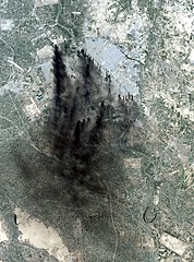
This image shows the city of Baghdad, the capital of Iraq. The dark smoke plumes are from pits of burning oil arrayed in a ring around the center of the city, a tactic used to stall and confuse invaders since medieval times. This picture is computer animated to show how it could look in reality. Baghdad Airport can be seen southwest of the city, just outside the smoke. This image was acquired by Landsat 7's Enhanced Thematic Mapper Plus (ETM+) sensor on April 2, 2003. |
|||||
| Tarih | Image taken on April 2, 2003. | |||||
| Kaynak | http://earthobservatory.nasa.gov/NaturalHazards/natural_hazards_v2.php3?img_id=10149 | |||||
| Yazar | Image provided by the USGS EROS Data Center Satellite Systems Branch. | |||||
| İzin (Bu dosyanın tekrar kullanımı) |
|

Dosya geçmişi
Dosyanın herhangi bir zamandaki hâli için ilgili tarih/saat kısmına tıklayın.
| Tarih/Saat | Küçük resim | Boyutlar | Kullanıcı | Yorum | |
|---|---|---|---|---|---|
| güncel | 05.58, 9 Ocak 2006 | | 889 × 1.200 (458 KB) | Slarre~commonswiki | This image shows the city of Baghdad, the capital of Iraq. The dark smoke plumes are from pits of burning oil arrayed in a ring around the center of the city, a tactic used to stall and confuse invaders since medieval times. Baghdad Airport can be seen so |
Dosya kullanımı
Bu görüntü dosyasına bağlantısı olan sayfalar:
Küresel dosya kullanımı
Aşağıdaki diğer vikiler bu dosyayı kullanır:
- bg.wikipedia.org üzerinde kullanımı
- ca.wikipedia.org üzerinde kullanımı
- cs.wikipedia.org üzerinde kullanımı
- cy.wikipedia.org üzerinde kullanımı
- da.wikipedia.org üzerinde kullanımı
- de.wikipedia.org üzerinde kullanımı
- en.wikipedia.org üzerinde kullanımı
- en.wikiquote.org üzerinde kullanımı
- es.wikipedia.org üzerinde kullanımı
- fi.wikipedia.org üzerinde kullanımı
- fr.wikipedia.org üzerinde kullanımı
- he.wikipedia.org üzerinde kullanımı
- ko.wikipedia.org üzerinde kullanımı
- no.wikipedia.org üzerinde kullanımı
- pt.wikipedia.org üzerinde kullanımı
- ru.wikipedia.org üzerinde kullanımı
- sv.wikipedia.org üzerinde kullanımı
- uk.wikipedia.org üzerinde kullanımı
- vi.wikipedia.org üzerinde kullanımı
- zh-classical.wikipedia.org üzerinde kullanımı
- zh.wikipedia.org üzerinde kullanımı