Dosya:Abu Reyhan Biruni-Earth Circumference.svg

Tam çözünürlük (SVG dosyası, sözde 1.000 × 900 piksel, dosya boyutu: 16 KB)
Bu dosya Wikimedia Commons'ta bulunmaktadır. Dosyanın açıklaması aşağıda gösterilmiştir. Commons, serbest/özgür telifli medya dosyalarının bulundurulduğu depodur. Siz de yardım edebilirsiniz. |
Özet
| Açıklama |
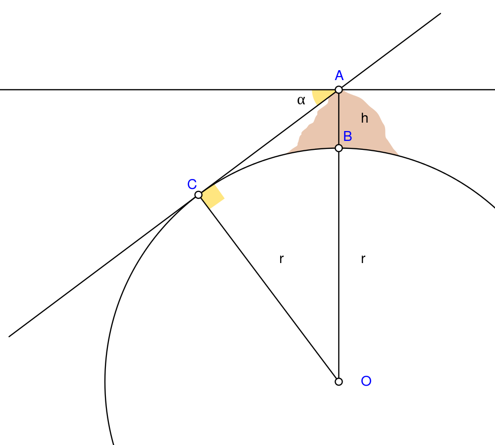
English: Biruni (973 - 1048) developed a new method using trigonometric calculations to compute earth's radius and circumference based on the angle between the horizontal line and true horizon from a mountain top with known height. He calculated the height of the mountain by going to two points at sea level with a known distance apart and then measuring the angle between the plain and the top of the mountain for both points.
Biruni's estimate of 6,339.9 km for the Earth radius had an error of 0.0026 and was 16.8 km less than the current value of 6,356.7 km. The idea came to him when he was on top of a tall mountain near Nandana in Pakistan. He measured the dip angle using an astrolabe and he applied to the law of sines formula. He also made use of algebra in his calculation.
Solution: Français : Biruni (973-1048) développa une nouvelle méthode utilisant la trigonométrie pour calculer le rayon et la ciconférence de la Terre, basée sur l'angle entre la ligne horizontale et l'horizon réel depuis le sommet d'une montagne de hauteur connue. Il calcula la hauteur de la montagne en se rendant en deux points situés au niveau de la mer dont l'écartement était connu, puis en mesurant l'angle entre la ligne horizontale formée par les deux points au niveau de la mer et le sommet de la montagne, et ceci depuis chacun des deux points.
L'estimation de Biruni de 6 339,9 km pour le rayon de la Terre comportait une erreur de 0,26 %, soit une valeur inférieure de 16,8 km par rapport à la valeur actuelle de 6 356,7 km. L'idée lui était venue alors qu'il se trouvait au sommet d'une haute montagne, près de Nandana en Inde. Il mesura l'angle d'incinaison avec un astrolabe et il appliqua la formule des sinus. Il fit également usage de l'algèbre pour ses calculs.
Solution : |
| Tarih | |
| Kaynak | Yükleyenin kendi çalışması Using Geogebra and Inkscape |
| Yazar | Nevit Dilmen |
| SVG gelişimi | Bu SVG kaynak kodu geçerlidir. Bu vektörel grafik Inkscape ile oluşturuldu. and with GeoGebra. Bu SVG dosyası, gömülü metin editörü kullanarak kolayca çevirebilir. |
Lisanslama
- Şu seçeneklerde özgürsünüz:
- paylaşım – eser paylaşımı, dağıtımı ve iletimi
- içeriği değiştirip uyarlama – eser adaptasyonu
- Aşağıdaki koşullar geçerli olacaktır:
- atıf – Esere yazar veya lisans sahibi tarafından belirtilen (ancak sizi ya da eseri kullanımınızı desteklediklerini ileri sürmeyecek bir) şekilde atıfta bulunmalısınız.
- benzer paylaşım – Maddeyi yeniden karıştırır, dönüştürür veya inşa ederseniz, katkılarınızı orijinal olarak aynı veya uyumlu lisans altında dağıtmanız gerekir.
Dosya geçmişi
Dosyanın herhangi bir zamandaki hâli için ilgili tarih/saat kısmına tıklayın.
| Tarih/Saat | Küçük resim | Boyutlar | Kullanıcı | Yorum | |
|---|---|---|---|---|---|
| güncel | 05.25, 2 Mayıs 2010 | | 1.000 × 900 (16 KB) | Nevit | Crop |
| 05.21, 2 Mayıs 2010 |  | 1.390 × 1.220 (16 KB) | Nevit | Yellow removed | |
| 05.19, 2 Mayıs 2010 |  | 1.390 × 1.220 (16 KB) | Nevit | Image version | |
| 05.18, 2 Mayıs 2010 |  | 640 × 480 (22 KB) | Nevit | {{Information |Description={{en|1=Biruni (973 - 1048) developed a new method using trigonometric calculations to compute earth's circumference based on the angle between the horizontal line and true horizon from a mountain top with known height. He calcu |
Dosya kullanımı
Bu görüntü dosyasına bağlantısı olan sayfalar:
Küresel dosya kullanımı
Aşağıdaki diğer vikiler bu dosyayı kullanır:
- af.wikipedia.org üzerinde kullanımı
- ar.wikipedia.org üzerinde kullanımı
- bcl.wikipedia.org üzerinde kullanımı
- bn.wikipedia.org üzerinde kullanımı
- bs.wikipedia.org üzerinde kullanımı
- diq.wikipedia.org üzerinde kullanımı
- en.wikipedia.org üzerinde kullanımı
- es.wikipedia.org üzerinde kullanımı
- fa.wikipedia.org üzerinde kullanımı
- fr.wikipedia.org üzerinde kullanımı
- he.wikipedia.org üzerinde kullanımı
- hr.wikipedia.org üzerinde kullanımı
- id.wikipedia.org üzerinde kullanımı
- it.wikipedia.org üzerinde kullanımı
- ja.wikipedia.org üzerinde kullanımı
- ps.wikipedia.org üzerinde kullanımı
- pt.wikipedia.org üzerinde kullanımı
- pt.wikibooks.org üzerinde kullanımı
- ro.wikipedia.org üzerinde kullanımı
- ru.wikipedia.org üzerinde kullanımı
- sd.wikipedia.org üzerinde kullanımı
- sh.wikipedia.org üzerinde kullanımı
- sr.wikipedia.org üzerinde kullanımı
- ta.wikipedia.org üzerinde kullanımı
- tt.wikipedia.org üzerinde kullanımı
- uk.wikipedia.org üzerinde kullanımı
- uz.wikipedia.org üzerinde kullanımı
- www.wikidata.org üzerinde kullanımı
Bu dosyanın daha fazla küresel kullanımını görüntüle.